

parky - Jun 24, 2011 7:14 am - Hasn't voted
Approach from FourfourasThanks for this useful map. I've done the Psiloritis ascent from Fourfouras twice now, most recently involving a night on the summit, then a descent over the NW ridge via Migha to Aravanes meadow and Arkadi.
I plan to write an article sometime on the whole trip, but would offer the following useful tips in the meantime to anyone planning an ascent from Fourfouras.
There's a daily 7am "Amari bus" from Rethymnon which is ideal for access. It sometimes leaves early, and isn't always shown in printed timetables. But it's a school service and doesn't; seem to change throughout the year.
1) Ask the bus driver to stop at the supermarket at the far end of the village -otherwise you'll have an extra walk from the village centre, just outside the school.
2) I think your time is an underestimate. With a full sack and bivi food for possibly 2 nights out (incl. 5litre of water) it took me 6 hours incl stops to the EOS, then another 4 to reach Psiloritis summit from the hut. There's lots of shelter at the EOS hut to avoid midday heat, though hut is locked. There's a well behind the hut. You'll need a piece of cord and the means to purify this rather foul looking supply.
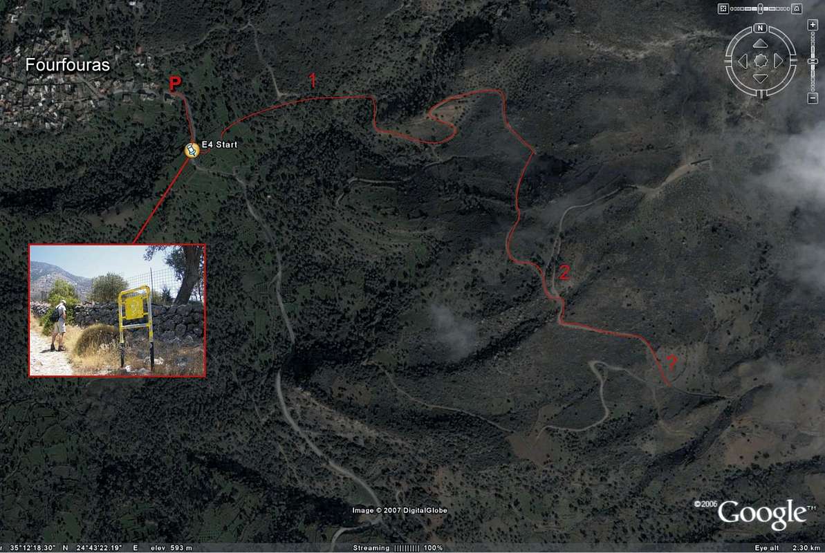
3) Your red line does work, but I feel takes you on a slightly longer path than is needed, and away from the waymarked route. So try this, which is based on my experience of using the description in "The High Mountains of Crete" by Cicerone Press:
a)From the yellow signpost on the Fourfouras road, walk up the track just 30metres. At a wall, follow waymarking sharp right to follow a fenceline that runs parallel with the main road. This soon passes a small chapel on your right and continues onwards along a 4x4 track in a SE direction.
b) At a Y junction with a yellow and black marker pole, turn sharply back NE. (The right fork soon goes downhill, so you'll know if you've gone wrong here).
c) The left turn, though counter-intuituive, soon bends round to continue in a SE direction. At the next T-junction of tracks (yellow marker pole) turn right. The track coming from the left would appear to be the track shown on your helpful Google Earth map.
d) Continue SE-wards, eventually reaching a large T-shaped concrete water trough and spring. Just beyond it a yellow marker indicates the correct track, which now rises sharply uphill, away from the 4x4 trail you have so far been on.
e) After c.10 mins of ascent on this track you'll reach a higher 4x4 track with fencing and an obvious metal gate at the foot of a rocky ravine.
f) It's now time to change from sandals into proper boots and to head directly up the shady ravine in front of you, which appears full of jumbled limestone blocks at its foot. It soon eases into a beautifully remote and rocky gully with plenty of respite from the morning sun as you ascend.
f) I put a few cairns at the foot of the gully, but beyond it there are no markers until you finally reach the head of the gully, where paintmarks take you rightwards, and then E4 plates fixed to trees direct you eastwards towards the obvious EOS hut.
g) Since 2006 there is a Topo25 map of Psilorotis at 1:25,000 scale which marks this route, though shows it rising to the side of the ravine, not on its floor. I think is an error, as the ravine floor, though steep, is perfectly navigable and is waymerked in its upper reaches.
4) On my first attempt along the NW ridge I awoke from my chosen bivvi spot on the summit to cloud and driving rain and decided at Spathi col to change my plans and return to catch the afternoon bus or to hitch back to Rethymnon. Note that the Amari-Rethymnon bus does not pass through the nearest village (Vistagi). I was lucky to be given a lift by a shepherd who took me back to Fourfouras to catch the 3pm bus back. But it's a very long and winding road down if you do choose to go this way!
Enjoy.

Rick B - Nov 6, 2011 6:40 am - Hasn't voted
Re: Approach from FourfourasHello Parky,
I'm sorry for the late reply! I've not been very active on SummitPost lately.
But thank you for the very valuable information, this will surely help people on their way. I have added some references to it on the main page of Psiloritis, and I'll edit the caption on this picture too, to make sure people don't miss your comment.
The 8-10hr time frame was what it took for us to go up and get down, but I must admit that we kept a quick pace and were both young and fit guys. Before we started, we met and old man in Fourfouras, who said it took him 10 hours as well. We didn't believe him then (we thought it would be shorter), but found out he was quite correct! I wonder if he would still be able to make it in 10 hrs, but you never know with these old mountain men.. He might be doing it every weekend :-) Anyway, I've extended the time frame to 8-12 hrs in the caption above.
Cheers,
Rick


Comments
Post a Comment