
-
 6668 Hits
-
 73.06% Score
-
 3 Votes
|
|
Route |
|---|---|
|
|
47.26630°N / 13.76060°E |
|
|
Mountaineering, Scrambling |
|
|
Summer, Fall |
|
|
Most of a day |
|
|
Walk-up, easy climb up to UIAA II. |
|
|
Introduction
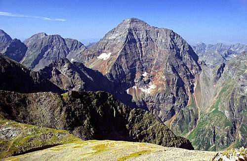
The ascent on the highest mountain of Niedere Tauern is a beautiful, but not just trivially easy hiking tour. The described northern variant is more often used than the western approach, from the Landawirseehütte, and here we can also experience the magnificent impression of the northern amphiteater. In the upper part of the tour an experienced hiker is encouraged to do a short and quite easy ridge climbing, which makes with the descent by normal variant a fine combination. The normal route is called also "Historisches Weg".
General characteristics
We first gain the notch on the right and then go by the other side on top
Difficulty. The normal ascent is a medium demanding hike up, on the Swiss Hiking Scale its difficulty would be graded T4. The summit slopes are steep and the trail is artificially secured only on some places, so that for maintaining balance you need hands. On the normal route the climbing difficulty nowhere exceeds the UIAA I level. On the unsecured ridge variant, the climbing difficulty is up to the level of UIAA II, by hiking standards it would be T6/T5.
Gear. Good shoes and poles. For the ridge variant, less experienced can be secured by rope.
Start altitude. The Untertal parking place, near the Riesach waterfalls, 1075 m (47.327659, 13.758934).
Altitude to overcome. 1800 m.
Times:
- Parking place – Gollinghütte: 2 h 15 min.
- Gollinghütte – Gollingscharte: 2 h 30 min.
- Gollingscharte – summit: 1 h 45 min.
Slopes orientation. Till the saddle towards the NE, the summit slopes towards the W and SW.
Best months. Dry season, approximately from mid July till the first snow.
Route Description
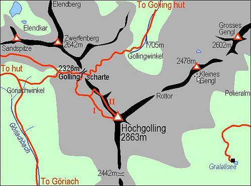
Hochgolling and its routes
To Gollinghütte
From the parking place we continue by the right road, heading southwards, mostly close to the Steinriesenbach (creek). Only above the Stegeralm (meadow), where there's the lower station of material cableway, the road turns into a broad path, which soon brings us to the Gollinghütte, 1641 m.
To Gollingscharte
From the hut we continue towards the S and soon reach Gollingwinkel, teh beautiful meadow, where the valley ends below the Hochgolling N wall. The path crosses the creek towards the right and ascends in many turns steeply up towards the SW. Higher, grassy slopes end and over rocks and debris we reach the Gollingscharte (notch), 2320 m. From the other, W side (Landawirseen), another path reaches this notch.
To the top
From the notch we continue towards the left. The path crosses over rocks, some iron pegs help us to overcome steeper sections. Only when the slopes orientation turns into the SW, on the altitude of 2630 m, we find ourselves in the middle of the SW face. There the path branches.


1. The left branch
The ridge variant (not secured), leads us steeply up, until we reach the NW ridge of Hochgolling. Climbing it is a beautiful experience! Endless views on all sides, and also an interesting, easy climbing sections. Only a few hardest sections of the ridge are avoided by detours on the right, southern side, so the difficulties nowhere exceed the degree of UIAA II (mostly I). The most difficult place is high below the summit, overcoming those rocks we are already almost on the top.
2. Normal route (Historisches Weg)
It continues by the SW face, but also gains altitude fastly. Also this route demands some mountaineering experience and easy climbing, but is nowhere harder than degree UIAA I. On some places it is also protected by steel pegs. In early summer on this route old snow rests can be dangerous. For an experienced mountaineer, the best combination is ascending by the NW ridge and descending by the normal route.