
-
 9806 Hits
-
 75.81% Score
-
 6 Votes
|
|
Route |
|---|---|
|
|
46.15689°N / 10.49540°E |
|
|
Mountaineering |
|
|
Spring, Summer |
|
|
One to two days |
|
|
Glacier, I UIAA to reach the top |
|
|
Overview
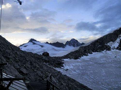
Adamello from Val di Genova across Mandrone Glacier
Adamello 3539 m is the highest peak and the most important one of the namesake group, the Adamello group, located beetween Lombardia and Trentino countries. Adamello is situated between M. Falcone and Passo dell'Adamello and has a fairly simple topography, drawn by the two main watershed ridges, the ENE ridge and the SW ridge, and by the NW spur. Its two great North and West walls give the mountain a majestic and harsh appearance, while the South East side is much more gentle, rising like a modest dome from the frozen plains of Pian di Neve. Along this side, with departure from the Val di Genova on the Trentino side of the chain, it developes the Normal route that we will describe later.

|

|
Getting there
The starting point to approach the huts is Val di Genova.
From Carisolo (TN) follow the road of the Val Genova and, upon reservation at the shelter, park in the parking area of Malga Bedole. In summer from 9.45 to 18.00 the stretch of road: Ponte Maria - Malga Bedole is forbidden to car traffic and there is a shuttle bus service that runs every 30 minutes. In this case park in the large parking area of Ponte Maria (1164 m), 8.5 km from Carisolo, near Malga Genova and reach the departure by shuttle bus.
It is also possible to start the climb from Rifugio ai Caduti dell’Adamello alla Lobbia. From Rifugio Collini in Val di Genova with a steep trail we can reach Rifugio Città di Trento The route is marked in RED COLOUR on the overview map.

Route Description
Adamello ENE ridge
Difficulty: Alpine F
This route is considered the Normal route for the alpinists starting from Rif. Città di Trento and Rif. Lobbia, the Normal Route from Trentino, usually rather crowded. The itinerary largely coincides with the itinerary of the first climbers of Monte Adamello and in the upper part near the eastern side of the Corno Bianco it joins the route coming from the Lombardia side.

|

|
Route report
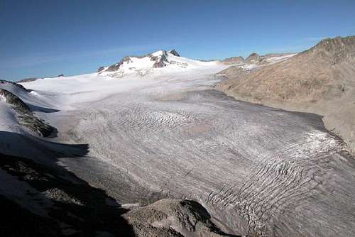
From the parking lot of Malga Bedole the road soon leads to the Rifugio Bedole 1641 m. From here, following the signs, take the well-marked path that rising to the North trail n. 212 with numerous hairpins a steep wooded slope. After about half an hour you will cross the stream that descends from Val Ronchina to the right. Continue through the wood which becomes more and more sparse, gradually turning towards W. The path crosses the creek, this time towards West, and little further on reachs the junction with the Migotti path which goes up to the Val Cèrcen. After ignoring this path, continue on the left, on the beautiful trail that leads, with a very scenic itinerary, to the ruins of the Capanna Lipsia and a little further on to the Rifugio Città di Trento al Mandròn (2449 m). From the Rifugio Città di Trento follow the marked path that leads downhill to the basin of Lago Mandrone. Continue for a long time in the SSW direction and after passing some bumps with numerous ups and downs, you reach the eastern slopes of Monte Mandrone. Following the signs, on scree and moraine ridges, we arrive at the front of the glacier. After tying up, cross the first part of the glacier to the left, then heading towards the SW spur of Lòbbia Alta. You pass a serac area and reach the glacial slope between the Lòbbia Alta and the Cima Giovanni Paolo II, go up it paying attention to the many crevasses, until you reach the Passo della Lòbbia Alta and the nearby Ai Caduti dell'Adamello refuge 3040 m , 5-6 hours from Malga Bedole.
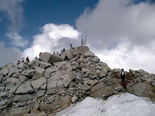
From Rifugio Ai Caduti dell'Adamello go down the crevassed glacial slope climbed the previous day and as soon as possible skirt the rocky spur of Cima Giovanni Paolo II. Then proceed on the glacier in the SSW direction, with a moderate slope. After having skirted at a distance the W sides of the aforementioned peak and of the Dosson di Genova, the route gradually turns towards the SE spur of the Corno Bianco which is bypassed to the left. Continuing towards WNW you cross the vast plateau between Corno Bianco and Monte Adamello, also here pay attention to the crevasses, and then go up until you reach the rocky southern slope of Monte Falcone. Skirting these rocks at the base, you reach the saddle under the steep ENE ridge of Monte Adamello. Climbing now on the rocky blocks of this ridge, with short passages on rocks, you reach a slightly inclined section, with residues of snow and then the easy broken rocks that lead to the summit, about 3,30 h from the refuge.
(Route also possible by ski-mountaineering; in this case it is also possible start the trip from Passo del Tonale, Presena Glacier skiresort).
Final part of the route (common to other routes) on Pian di Neve glacier
At the end of the climb, from 3100 m a.s.l. about to the top, the route is common to the route that comes from Rifugio Garibaldi. The Pian di Neve is an unicum in the Italian Alps. Be careful to hide crevasses!!!
Essential Gear
Crampons, ice-axe, rope.
 |
 |
 |
Red Tape

No fees no permits needed and no particular restriction in climbing and hiking. Adamello is located within Adamello-Brenta Natural Park, the largest protected area in Trentino, established in the year 1967. It's located in Western Trentino and with its 620.51 square kilometers includes the mountain groups of Adamello, Presanella and Brenta Dolomites, separated by Val Rendena. Pay attention to the accessibility of Val di Genova road (usually closed to private cars in summer). In the summer, from 9.45 am to 6.00 pm the stretch of road Ponte Maria - Malga Bedole is closed to private cars traffic and the shuttle bus service runs every 30 minutes. In this case, park in the large parking area of Ponte Maria at an altitude of 1164 m, 8.5 km from Carisolo, near Malga Genova and reach the departure by shuttle bus.
Huts

- Rifugio Città di Trento al Mandrone - Approach from Rifugio Collini al Bedole (trailhead) in Val di Genova. The road to Val di Genova starts from Carisolo.

- Rifugio Lobbia ai Caduti dell’Adamello - Approaches: A) From Val di Fumo, Rifugio Val di Fumo and Lobbia glacier. B) From Val di Genova, Rifugio Città di Trento al Mandrone across the Mandrone glacier. C) From Rifugio Collini al Bedole (trailhead road Val di Genova) directly through the Lobbia Valley.
Meteo
Guidebooks and maps

- Guidebooks
"Adamello Vol. I - Pericle Sacchi Collana Guide dei Monti d'Italia CAI-TCI
-Maps
"Adamello - Presanella" - Tabacco scala 1:25000
"Adamello, Val di Fumo, Val di Genova" - Kompass n. 638
"Adamello - Presanella" - 4LAND Alpine Cartography n. 138 1:25.000