
Introduction
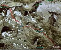 Bear Creek Spire Track
I created this list of GPS tracks to help facilitate the sharing of GPS data among us Mountaineers. I find it is often hard to find tracks of routes, and they are great for planning. Many of these tracks include photo placemarks that help you visualize what the terrain is like at the exact point the photo was taken along the track. These can all be viewed with Google Earth. If you don't have it installed on your computer, I recommend downloading it now (http://earth.google.com/download-earth.html) as it is a great tool for Mountaineering. The following article has more information on using GPS data with Google Earth (GPS and Google Earth).
For many more GPS Tracks in both Google Earth KMZ format as well as GPX format for uploading to GPS units, check out my website:
http://www.gpsmountaineering.com
GPS Tracks
 Mount Whitney Track
 Mount Hawkins Track
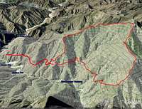 Rattlesnake Peak Track
San Gabriel Mountains:
Rattlesnake Peak in the San Gabriel MountainsMount Markham in the San Gabriel Mountains (with photos)
Sugarloaf, Ontario, Bighorn, Cucamonga and Etwanda Peaks in the San Gabriel Mountains (with photos)
Mount Hawkins, Middle Hawkins, Sadie Hawkins and South Mount Hawkins in the San Gabriel Mountains (with photos)
Iron Mountain in the San Gabriel Mountains
Mount Baldy, Harwood, Thunder, Telegraph and Timber in the San Gabriel Mountains
Mount Wilson via Baily canyon in the San Gabriel Mountains
Strawberry Peak in the San Gabriel Mountains
Sierra Nevada Mountains
Mount Whitney in the Sierra Nevada Mountains (with photos)Mount Russell in the Sierra Nevada Mountains (with photos)
Mount Langley in the Sierra Nevada Mountains (with photos)
Bear Creek Spire in the Sierra Nevada Mountains (with photos)
Santa Monica Mountains
Brents Mountain in the Santa Monica MountainsSandstone Peak in the Santa Monica Mountains (with photos)
Other Peaks
White Mountain in the White Mountains (with photos)Mount Inspiration in Joshua Tree National Park (with photos)
San Jacinto Peak in the San Jacinto Range (with photos)
External Links
www.gpsvisualizer.comA great website to convert GPS tracks (i.e. convert kmz to gpx for downloading to GPS unit).
www.gpsmountaineering.com/
My website containing additional information on all of these hikes