Impressive mountain at the end of long N-NE Tsanteleina (3.601m) Buttress. In the shape of right-angle trapezium with vertex in South and the base in East up a great wall and sited among Tsanteleina (E) and Goletta/Rhêmes Glaciers (W and SW). A full account of all routes from West (8: A, B, C, D, E, F, G, H) and from North (2: K, X).
Imponente montagna al termine del lungo Contrafforte N-NE della Tsanteleina (3.601 m). A forma di trapezio rettangolo con il vertice a Sud e la base ad Est, sopra una grande parete, è posta "a cavallo" dei Ghiacciai di Tsanteleina (E) e di Goletta/Rhêmes (W e SW). Analisi completa di tutte le vie da Ovest (8: A, B, C, D, E, F, G, H) e da Nord (2: K, X).
First Ascents
N-NW Edge: R. C. Nichols, T. Blanford, E. P. Rowsell and mountain guides J. V. Favret and N. Jacod, (Aug 22th, 1863).
NW Little Gully: Lorenzo Merli and Raffaele Piller, (Jul 19th, 1983).
W Wall, direct route to North Summit: Osvaldo Cardellina and Reinhart Lohrmann, (Jul 28th, 1968), and crossing to Traversière Becca/Bassac Déré Pass.
W Slope, normal route: W. A. Coolidge and mountain guide Christian Almer, (Sep 25th, 1886).
W Face, direct route to South Summit: Osvaldo Cardellina, Sergio Roverso and Nino Trapani, (Jul 14th, 1974), in day from Rhêmes Notre Dames and crossing to Traversière Becca/Bassac Déré Pass.
W-SW Edge of triangular W-SW Face: Osvaldo Cardellina, solo, (Jul 20th, 1997), in day from Pellaud.
SW Slope: Giovanni Bobba and Casimiro Thérisod, (Jul 24th, 1888).
S Ridge: A. Pigeon, E. Pigeon and mountain guides Jean Joseph Maquignaz and Daniel Balley, (Jul 26th, 1875), in ascent. Osvaldo Cardellina, solo, (Jul 20th, 1997), in descent and in day from Pellaud.
Getting There
BY CAR:
From France, through the Mont Blanc Tunnel or the Col du Petit Saint Bernard: you can drive on SS.26, following directions for Aosta and, before arriving in Villeneuve, turn right towards Introd. Alternatively, you can take Motorway A5 (at Courmayeur or Morgex) and exit at Aosta Ovest.
From all the other directions: get to the Aosta Ovest exit of Motorway A5. Then drive on SS.26 Aosta, in the direction of Courmayeur; just after Villeneuve turn left towards Introd.
BY PLANE:
Aeroporto "Corrado Gex" Saint Christophe (Aosta).
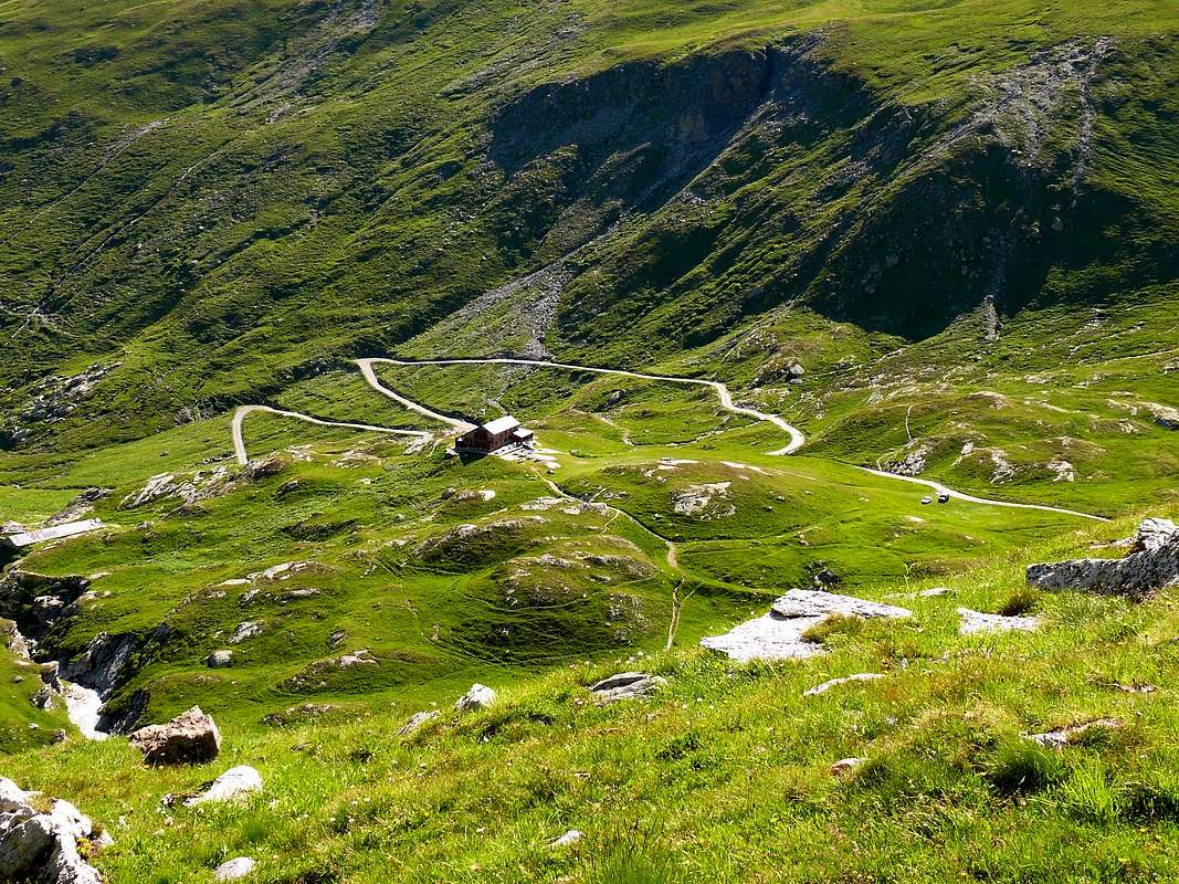
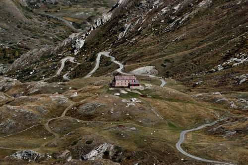
Enter the valley and, at the fork between Valsavarenche and Val di Rhêmes turn to the right (Rhêmes). Cross all the villages to arrive to Rhêmes Notre Dame and follow to Thumel (car parking), herefrom, following the dirt road on the right side (ascending) of the valley, or, better with snow, a track on the left that passing throught some fine woods leads you to the Rifugio Benevolo (2.285m).
Approachs
Approach 1): To routes 1/5 (A, B, C, D, E). From Federico Benevolo Refuge go down (SW direction) at small bridge (2.269m) over Rhêmes Dora Stream; by a diagonal path 13d, HRG (High Glacial Route) go to the fork (2.420m, (little cairn); leaving to the left (S) the path n° 13c (toward Truc Saint-Hélène and Tsanteleina Lake), turn right (NW) climbing the grassy promontory (2.615m). Change again direction (S-SW) and reach the last ramification of Granta Parei long N-NE Spur. Continue below the crest to the right (W), by obvious trace and white limestones debris to quota (3.078m) at the beginning of N-NE ridge; turn 90 degrees West and cross the Higher Goletta Glacier staying high, below the N Face, skirting N-NW ridge at about 3.080/90m. Turn South and, by a progressive diagonal ascent, reach the start of the W slope routes. (2h'00/2h'15).
Dal Rifugio Federico Benevolo scendere a SW al sottostante ponticello (2.269 m) sulla Dora di Rhêmes; risalire a NW in diagonale all'alpe di Sauches (2.313 m) con il sentiero n° 13d, HRG (Alta Via Glaciale), sino al bivio (2.420 m, ometto); lasciando a sinistra (S) il sentiero 13c (verso il Truc Sant'Elena ed il Lago della Tsanteleina), girare a destra (NW) e risalire l'erboso promontorio (2.615 m). Cambiare ancora direzione, salendo le estreme propaggini del lungo Contrafforte N-NE della Granta Parei. Procedere sottocresta ad W su evidenti tracce risalendo detriti e blocchi di bianco calcare sino a quota (3.078 m), all'inizio della Cresta N-NE; girare ad angolo retto ad W ed attraversare in quota l'Alto Ghiacciaio di Goletta, sotto la Parete Nord, sino a doppiare lo Spigolo N-NW a quota 3.080/90 m~ Con progressiva salita diagonale ai margini del ghiacciaio, dirigersi a S portandosi verso i varii attacchi delle vie del Versante Ovest. (2h'00/2h'15).
Approach 2): To routes 6/8 (F, G, H). Reach the base of the W face with the previous approach. Continue in the same direction, and go up to a snowy Saddle 3.140m~, to the E of quota (3.160m), between Goletta/Higher Rhêmes Glaciers. Turn to the left (S-SE) and gain the Granta Parei Pass by a snow slope (3.250m; 0h'30; 2h'30/2h'45).
Con il precedente avvicinamento sino alla base del Versante Ovest; procedere ancora con la stessa direzione portandosi alla Sella 3.140 m~, ad E della quota (3.160 m), e inserirsi dal Ghiacciaio di Goletta all'Alto Ghiacciaio di Rhêmes. Deviando leggermente verso S-SE, per un facile pendio nevoso, risalire al Colle Granta Parei (3.250 m; 0h'30; 2h'30/2h'45).
A) - N-NW Edge: from Goletta Glacier to double in right (W) the North Face and to climb, by moderates slopes and fair rock on the ridge; to continue (a little gully in right or S) in edge and through less goods rocks exit out to higher snowy and debris slope toward the N Summit. (PD+; II°-/II°+/III°-; 1h'30/2h'00).
A) - Spigolo N-NW: dal Ghiacciaio di Goletta doppiare a destra (W) la Parete Nord e portarsi sulla cresta con pendenze moderate e discreta roccia; quando questa si assottiglia (a destra sale un esilissimo canalino ghiacciato), uscire per rocce meno buone sul pendio sovrastante di nevati e roccette con detrito. (PD+; II°-/II°+/III°-; 1h'30/2h'00).
B) - NW Little Gully: to double the N-NW Edge in quota 3.080/90m~ and to go up diagonal right in initial part, by a snowy slope (30°, after 35°), near a rocky promontory in the shap of pear; to climb in parallel right to a very narrow icegully (40°; 150m; verglass possibility), between North and West Faces: exit out in E, by brokens and rottens rocks (II°-; 80m) to N Summit (AD-; 1h'30/2h'00; delicate with "verglass" and in terminal part).
B) - Canalino NW:doppiare lo Spigolo NW alla base a quota 3.080/90 m~ e risalire la parte iniziale su un pendio nevoso in progressivo aumento (30°/35°) sfociante in un esile ed angusto canalino, tra le pareti Nord ed Ovest; risalirlo (40°; 150 metri; spesso in verglass) uscendo a sinistra (E) su rocce rotte e anche marce per 80 m~ (AD-; 1h'30/2h'00; delicato se in ghiaccio vivo e nel tratto finale).
C) - W Wall, direct route to North Summit: to begin in perpendicular route to North Summit, between "canalino" (ice gully) and normal route. To go up by a progressive snowy slope (30°/33°/36°) toward a first rocky strip; to climb (II°/II°+) and to "touch" a first and brief debris balcony. By a short rocky passage to reach a second, more large and steep. To climb through rubbles and broken rocks at terminal of wall base, in quota 3.250m~.; to overcome, nearly directly (from right to left), by broken and difficult rocks, to North Summit (AD+; II°+/III°+, a passage IV°-; 2h'00/2h'30).
C) - Parete W, via diretta alla Punta Nord: iniziare perpendicolarmente alla Cima Nord, tra la via del canalino e la "normale" del Versante Ovest. Salire il pendio nevoso con pendenze in progressivo aumento (30°/33°/36°) dirigendosi ad una prima fascia rocciosa; superarla (II°/II°+) toccando una prima cengia detritica. Con un breve passaggio roccioso raggiungerne una seconda più ampia e ripida di rocce rotte e detrito, alla base del ripido muro terminale a quota 3.250 m~ Salirlo quasi direttamente da S a N su roccia rotta e difficile uscendo sulla Punta Nord (AD+; II°+/III°+, un passaggio di IV°-; 2h'00/2h'30).
D) - W Slope, normal route between two summits: to cross in right (S) half West Slope moving in centre; to go up the snowy slope (30°) up to a rocky narrowing (forced passage, very often frozen; dangerous for rocks falls together with numerous a group of rope climbers); to climb in right (S), by greats footholds with ice, also in left through a frozen "chimney" and to reach at higher debris and snowy slope (always "verglass"). To aim the "carving" between two summits, more to South. To cross in right (S) toward major Summit (3.387m) and in left (N), by a easy but exposed small crest, to North or traditional Summit (3.383m~). (F+; 1h'30).
D) - Via normale del Versante Ovest alla Sella 3385 m.~:attraversare a destra metà del Versante Ovest portandosi al centro con salita diagonale per il facile pendio nevoso (30°); raggiungere una strozzatura rocciosa (spesso ghiacciata e pericolosa per cadute di pietre in presenza di molte cordate). Superarla o a destra (S) per gradoni spesso gelati oppure a sinistra. Per un camino quasi sempre verglassato; superato questo passaggio forzato ci si immette al pendio superiore di roccette, detriti "legati" dal ghiaccio; mirare all'intaglio tra le due cime, uscendo più vicino alla Punta Sud. Sulla cresta sommitale, a destra facilmente alla Vetta più elevata (3.387 m); a sinistra con una crestina facile e divertente, ma esposta ad E, alla Cima tradizionale (3.383 m~). (F+; 1h'30).
E) - W Face, direct route to South Summit: to cross in right (S) the entire West Face and to double in right (S) a rocky islet, near the saddle 3.140m~; to go up directly by a easy snowy slope (30°) to a first rocky band. To climb (II°/II°+) and to reach a second snowy slope more steep (35°), near a second small saddle; to climb a second rocky strip, through a snowy gully, and to reach a steep, but brief, hanging snowfield, in quota (3.220m~) to cross directly ascent (37/8°) at a third rocky band, in quota 3.245m~. To overcome by more difficult rocks (II°+/III°-; 40m) and through broken rocks, debris and higher snowfield to South Summit (PD+; 2h'00/2h'15).
E) - Parete W, via diretta alla Punta Sud:attraversare completamente verso destra (S) tutto il Versante Ovest e doppiare a destra un isolotto roccioso, vicino alla sella nevosa (3.140 m~); con breve salita diagonale (30°) portarsi ad una prima facile fascia rocciosa. Superarla agevolmente (II°/II°+) e portarsi ad un secondo più ripido nevaio (35°) con roccette affioranti, presso una seconda e meno evidenziata selletta; oltrepassarlo, tramite un canalino nevoso, pervenendo al nevaio sospeso a quota (3.220 m~). Attraversarlo con salita diretta (37°/8°) dirigendosi verso una terza fascia rocciosa; vincerla per rocce più impegnative (II°+/III°-;. 40m) e per rocce più facili e rotte, detrito ed il nevaio superiore raggiungere la Punta Sud (PD+; 2h'00/2h'15).
F) - W-SW Edge of triangular W-SW Face: from saddle (3.140m~) to cross 40 meters in right (S) and to reach the base of rocky triangular W-SW Wall, in quota (3.120m~); to go up at small snowy balcony and to seize the higher edge. To climb by broken and steeps rocks following with progressive increase slope as far as 70/80 meters to South Summit (II°+/III°-/III°+, a passage IV°-); to finish by more easy and more broken rocks (AD+; 265/70m; 2h'30/3h'00).
F) - Spigolo W-SW della triangolare Parete W-SW:dalla sella (3.140 m~) attraversare ancora a destra per 40m~ raggiungendo la base della triangolare e rocciosa Parete W-SW a quota (3.120 m~); risalire ad una piccola cengia nevosa ed afferrare lo spigolo soprastante di rocce ripide e abbastanza rotte. Seguirlo con crescente e costante aumento della ripidezza sino a 70/80 metri dalla Vetta Sud (II°+/III°-/III°+, un passaggio IV°-); terminare su rocce più facili e meno solide (AD+; 265/70 m; 2h'30/3h'00).
G) - SW Slope: by previous route, to cross 100m in SE on Higher Rhêmes Glacier at SW Slope base, in quota (3.230m~); to go up, through a series of debris balcony and little couloirs (or along their shores), with various routes and to exit out in right (S) of the South Summit (PD+; 260m; 2h'00).
G) - Versante SW:con la via precedente, attraversare ancora per 100 metri a destra (SE), portandosi verso il centro del Versante SW, tutto cenge e canalini detritici o nevosi. Attaccare su una lingua di neve e seguirla per 130/40 m~, poi, senza percorso obbligato, sfruttando una serie di canalini (o lungo le loro sponde) alternati a cenge nevose o detritiche uscire subito a destra della Punta Sud (PD+; 260 m; 2h'00).
H) - S Ridge: from saddle 3.140m~. and preceding route, to cross in border the Higher Rhêmes Glacier and, by moderate snowy slope, to go up Granta Parei Pass (3.250m); from pass, by N direction, rubbles, broken rocks, to climb in edge the crest, doubling some passages (II°/II°+) in left (W), with great exposition in right (E). Through enough good rock to South Summit (PD; 135/40m; 1h'00).
H) - Cresta S:dalla sella 3.140 m~, tramite l'Alto Ghiacciaio di Rhêmes, portarsi con facile pendio nevoso e modeste pendenze al Col Granta Parei (3.250 m); dapprima su rocce frantumate e detriti, poi con roccia più sana, percorrere il filo di cresta, aggirando qualche passo sulla sin. (W), con grande esposizione ad E (II°/II°+) e raggiungere la Punta Sud, la più alta (PD; 135/40 m; 1h'00).
K1) - N-NE Edge: from quota (3.078m) continue easily through Granta Parei N-NE Spur, by debris, rubbles, broken little typical calcareous white and squared rocks and "surviving" snowfields (25°) go up toward a first in the shape round fragment rise amongst sparce blocks; doubling in left (East) a second dark rocky promontory, by a lengthened snowfield and join a stony tableland, laid out in E/W axe diagonal. Cross, by always South direction, at true and appropriate N-NE Edge, here pinkish rocks formed. Start, before by two brief rocky strip in diagonal descent to North Face and with two same inclined snowfields (I°+; 27°/28°), toward of edge more steep part, in quota 3.150/60m. Climb in right (West), by more and more steep rocks and go in a rocky and narrow gully (* in old times and until the Sixties/Seventies surely"verglass", reason major snowfalls in existence and minor a rise in temperature; like for the first mountaineers, forced to North Face, for exit out); liken the photos of 1968 year with those of 2010 same of season month, by as); to overcome exit out in edge (II°/II°+/III°-; pitons of safety in existence). Continue in higher part exposed, but easy (it's quite a different matter "verglass" extant) broken rocks, blocks alternate with debris balconys. Finish in East of North Summit (3.387m; aerial, little Virgin Mary statue; 3h'30 from Benevolo Refuge; 1h'15 from edge base).
K1) - N-NE Edge: Dalla Quota (3.078 m) continuare facilmente attraverso il Contrafforte N-NE della Granta Parei e, tramite detriti, frantumi, rocce rotte di caratteristico bianco calcare a forma squadrata e nevai "superstiti" (25°), risalire verso un primo dosso morenico con blocchi sparsi ed a forma tondeggiante; doppiarne sulla sinistra (E) un secondo di rocce scure su un nevaio allungato, raggiungendo un "plateau" pietroso, inclinato sull'asse E/W. Sempre in direzione S attraversarlo portandosi alla base del vero e proprio Spigolo E-NE, formato da rocce rosate. "Attaccare" a quota 3.150/60 m~ per mezzo di due brevi fasce rocciose, inclinate verso la Parete Nord ed intercalate da similari nevati (I°+; 27°/28°), indirizzandosi verso la parte più ripida dello spigolo vero e proprio; arrampicare a destra (W) e su rocce via via più ripide introdursi in uno stretto camino/spaccatura (* agli albori e fino agli anni 60/70 la presenza di ghiaccio-vetro era scontata per il maggiore innevamento esistente e minori temperature e la cresta era affrontata solo quando fosse "pulita"; così fu per i primi salitori, costretti a deviare sulla Parete Nord nel tratto terminaleAnalizzare le foto del 1968 con quelle di as del 2010, a parità di periodo stagionale). Vincere il passaggio uscendo sul fil di cresta (II°/II°+/III°-; chiodi di sicurezza in loco). Proseguire nell'ultima parte, esposta ma facile (ben altra cosa in presenza di ghiaccio "vivo"), su rocce rotte e blocchi, alternate a cengie detritiche "uscendo" a sinistra della Vetta N (3.387 m; aereo; statuetta della Madonna; 3h'30 dal Benevolo; 1h'15 dalla base dello spigolo terminale).
K2) - NE Ridge (Variant by as): from quota (3.078m) continue easily on the broad N-NE Spur, on debris made of typical white limestone and "surviving" snowfields, aiming toward base the yellow/pink rock wall above. The top part of the rock wall is carved by a characteristic gully, equipped with few new pitons for belay and safety. Reach the gully (belay piton to the left) an climb it (20m II°-III°). At the end of the gully an airy ridge of broken rocks leads to the final wall before the summit. There is a belay piton at the base of the final wall. From this balay reach the north summit directly over a small overhanging step (IV-) or with a traverse to the left crossing over steep debris. Beautiful view from the summit 3.387m where the little Virgin Mary welcome the visitor and provides the final belay anchor (4h'00 from Benevolo Refuge). Beware of the rock quality which is not very good on this route, as well as for all routes of this mountain. (*In old times and throughout the Sixties/Seventies this route was usually in snow and ice, and the steep gully was a serious obstacle to overcome with old tools; like for the first climbers, forced to exit by the North Face).
K2)- NE Ridge (Variante as):Dalla quota (3.078 m) proseguire facilmente seguendo il crestone N-NE su detriti di tipico calcare bianco e, superando qualche nevaio superstite, indirizzarsi alla base del salto roccioso sovrastante di rocce giallo/rosa. La parte alta di questo salto roccioso è intagliata da un caratteristico canale ed è attrezzato con spit nuovi. Raggiungere il canale con facile arrampicata (c'è uno spit alla base del canale a sinistra) e risalirlo fino al termine (20 m II-III). Alla fine del canale proseguire su un aerea cresta di rocce rotte fino al risalto roccioso finale. C'è uno spit alla base di questo risalto roccioso. Da questo punto raggiungere la cima nord proseguendo direttamente superando un passaggio leggermente strapiombante (IV-) oppure deviare a sinistra attraversando canali di detriti su terreno ripido e infido. Bellissima vista dalla cima dove una statua della Madonna ci attende e fornisce il punto finale di assicurazione (4 ore dal rifugio). Attenzione alla qualità della roccia che è mediocre su questa come sulle altre vie di questa montagna. (In passato, negli anni sessanta/settanta questa via era generalmente di neve e ghiaccio e il canale finale era un serio ostacolo considerati gli attrezzi dell'epoca, come per i primi salitori che furono obbligati a deviare sulla parete N).
X) - N Face: from quota (3.078m) continue easily on N-NE Spur and crossing, practically level route also in "soft" ascent diagonal in right (W), to N Face, in center and in quota 3.100m~. Go up directly on the snowy wall (or icy) by progressive slope (30°/33°/37°), moving in right at, of typical rocky band dividing in two parts the face, base. Climb, before in right (West; II°/II°+/III°-; more variable rock: fairly solid also friable), after in left (East) by a crack/gully/"chimney", and to come out on higher snowfield (often"verglass"); going, by greater slopes (38°/40°, even 42°/45°), finish near the little Virgin statue (1h'30/2h'00; much variable, for of ice state). Brief Variant: from the end of snowfield, exit out in diagonal right (W) to great shoulder of -NW Ridge (about 40/45 meters from Summit) and, by same with easy but friable rocks, to finish; also double in West. Same time.
X) - N-NE Edge: Dalla Quota (3.078 m) continuare facilmente, attraverso il Contrafforte N-NE della Granta Parei, pressocché in quota o con leggera salita diagonale ad W, portandosi al centro della Parete N, a quota 3.100 m circa. Risalire direttamente lo scivolo innevato (o ghiacciato) con pendenze in progressivo aumento (30°/33°/37°) indirizzandosi alla base della caratteristica fascia rocciosa, spezzante in due la parete. Superarla dapprima verso destra (W; II°/II°+/III°-; roccia molto variabile, da discreta a scaglie molto friabili), poi a sinistra su una fessura/strettoia a camino, uscendo sul nevaio superiore (spesso "verglass"); risalirlo con pendenze maggiori (38°/40°, anche 42°/45°) ed uscire presso la Madonnina (1h'30/2h'00; molto variabile per le condizioni del ghiaccio). Piccola Variante: dalla fine del nevaio, uscire in diagonale a destra (W) sullo spallone della cresta N-NW, ad un tiro di corda dalla Vetta, e tramite questa, su rocce facili ma friabili, concludere; oppure doppiarle ad W. Stesso tempo.
Parents refers to a larger category under which an object falls. For example, theAconcagua mountain page has the 'Aconcagua Group' and the 'Seven Summits' asparents and is a parent itself to many routes, photos, and Trip Reports.

 8931 Hits
 86.85% Score
 23 Votes