
-
 7433 Hits
-
 92.59% Score
-
 39 Votes
|
|
Mountain/Rock |
|---|---|
|
|
36.39652°N / 74.47258°E |
|
|
Mountaineering |
|
|
17126 ft / 5220 m |
|
|
Overview

Gutum Talji Peaks
Gutum Talji is located in the Muchuhar Valley, which is in the Batura Muztagh, the westernmost sub-range of the Karakoram. Although it is surrounded by higher peaks, Gutum Talji has a distinctive and attractive appearance.
The mountain consists of two separate summits, and the highest of these was first climbed by Pete Thompson, Tom Goodwin and Johannes Gouws in August 1996. They climbed a route on the north face from the Yain Hisk Cirque.
Getting There
The nearest international airport is Islamabad. PIA flies daily from Islamabad to Gilgit, the biggest town in the Northern Areas. The flights are sometimes cancelled at short notice due to bad weather.
Gilgit can also be reached by bus along the Karakoram Highway from Pir Wadhai bus station in Rawalpindi. Buses leave in the afternoon and arrive around mid morning the next day, but can be delayed if the road is washed out or blocked by landslides. See www.lonelyplanet.com/thorntree for a travel forum and the latest on travel on the Karakoram Highway.
From Gilgit get a Hiace van up the Karakoram Highway to Aliabad (3 hours drive) in the Hunza Valley. Aliabad is the closest village to the start of the trek up the Muchuhar Valley to Base Camp. Otherwise, get a Hiace van to nearby Karimabad which is a pleasant place to stay.
The Karakoram Highway continues north of Karimabad up the Hunza Valley to Passu and over the Kunjerab Pass to Kashgar in the Xingjiang Province of China.
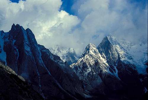
Gutum Talji Northeast (left) and Pute Tower III (right)
Trekking to Base Camp
Porters can be hired in Aliabad. Pay will be per stage. On trekking routes there are established stages representing a day's walk, although sometimes more than one stage is walked in a day. Stages tend to be based on the best places to camp. Rates per stage are governed by the Ministry of Tourism, but will vary according to local conditions.
The trek up the Muchuhar Valley starts at Hassanabad, a few kilometers from Aliabad. There is a good track as far as the snout of the Hassanabad Glacier. Climb onto the glacier and cross to the west side. Follow the edge of the glacier, then an intermittent trail on the rubble-strewn glacier itself which becomes the Muchuhar Glacier. Climb steeply up to base camp at 3750m in an ablation valley north of the Yain Hisk Glacier and beneath the southeast face of Hacindar Chhish.
Hunza Landslide
On January 4 2010 a massive landslide occurred 14 km upstream from Karimabad at Attabad village killing twenty people. The flow of the Hunza River was blocked for five months creating a lake 21 km long and 100m deep known as Attabad Lake. 6,000 people were displaced from inundated villages and 19 km of the Karakoram Highway were destroyed.
A major flood downstream was feared as the water level approached the top of the dam. This did not happen as water began flowing over the dam in June 2010. In 2012 the spillway was blasted twice and the water level of the lake was reduced by ten metres.
Boats carried people across the lake until 2016 when the Chinese finished building a road past the lake, including several tunnels.
Red Tape
A visa is required and must be obtained prior to arrival. A single entry tourist visa is valid for three months from arrival. It is possible to extend visas in Islamabad.No peak fee is payable for peaks below 6500m in the Pakistani Karakoram. A liaison officer is not required. An agent can provide a guide and Base Camp staff if required and assist with hiring porters.
Good agents I have used are:
1. Adventure Tours Pakistan
2. Himalaya Trek and Tours
Camping
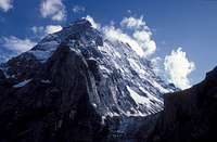
Gutum Talji Northeast Peak
Campsites
Base Camp is in a pleasant, wooded ablation valley with good water. There might be cattle here and food needs to be well protected when you’re away from camp.
Camping Fuel
Kerosene is available in Gilgit and other towns but it is not very clean so be prepared to clean your stove. White gas is not available. Gas canisters left by previous expeditions are available in Gilgit. Canisters are said to be refilled, but they have always worked for me. Otherwise canisters will need to be freighted from abroad or bought from your agent.
Expedition Food
A good selection of food is available in Islamabad, Gilgit or Karimabad. The only food you might consider bringing with you is special mountain food.
Accomodation
This can be cheap in Pakistan. In Gilgit the Madina Guesthouse is recommended. Karimabad is a good place to relax after climbing. The cheap guesthouses around Zero Point are a good place to stay. I like the Haider Inn.
The Route

Gutum Talji North Face Routes
Part of the challenge was getting into the Yain Hisk cirque which is guarded by a steep icefall. Above Base Camp we fixed a rope on a rock step which gave access to high pastures. We climbed up the pastures running along the northern edge of the Yain Hisk Glacier. Once above the icefall we made a 50m abseil down into the cirque. We were probably the first people to set foot in the cirque. It was interesting to look at the Southwest Face of Hachindar Chhish which looks very difficult from this side.
We bivied beside the glacier and Thompson, Goodwin and Gouws traversed under the North Face of Gutum Talji from the west. A gully led up the North Face onto the West Ridge which led to the summit. Meanwhile Pete Scott and Sam Stacey attempted a more direct line on the North Face, but retreated when Pete Scott was hit by a rock. We all left the cirque by jumaring back up the rope which we had left in place.
When to Climb
The climbing season is from June to mid September. The monsoon from the Bay of Bengal moves westward and reaches Pakistan in late June through to September. The Karakoram is in the Himalayan rain shadow which limits the effect of the monsoon. However when the monsoon breaks down country it’s usually stormy in the mountains. The weather can change very quickly with snow fall higher up or heavy rain at lower altitudes. Climbing in the Karakoram requires considerable patience.
Research

Aikache Chhok
Maps
Batura Mustagh Orographical Sketch Map 1:100,000 by Jerzy Wala.
An excellent and accurate map which also includes topo-diagrams of some routes on the higher peaks.
Swiss Foundation for Alpine Research Karakoram 1:250,000 Orographical Sketch Map. Sheet 1 shows Batura.
Popular and useful maps which are generally accurate.
Books
Chronik der Erschließung des Karakorum by Wolfgang Heichel. Teil I – Western Karakorum. Wissenschaftliche Alpenvereinshefte, Heft 36. Gemeinsam herausgeben vom Deutschen und vom Österreichischen Alpenverein. München 2003.
This is the first volume of what is intended to be an exhaustive chronicle of the climbing history of the Karakoram range. It contains stacks of useful information and excellent maps by Jerzy Wala. Volume I covers the mountains west of the Hunza River including the Batura Muztagh. Volume II is intended to cover the Rakaposhi Range and Volume III the Hispar Range. Only available in German.
Karakoram: Mountains of Pakistan by Shiro Shirahata (1998) ISBN: 093856725X
Stunning photos including Hachindar Chhish.
External Links
www.climbmagazine.com for Mountain Info, a record of world mountaineering.
www.americanalpineclub.org for online American Alpine Journal expedition reports.
www.alpineclub.org.uk for the Himalayan Index, a useful starting point to determine what has been climbed on peaks 6000m and above.
http://blankonthemap.free.fr/default.htm is a website in French and English devoted to the mountains of Northern Kashmir i.e. the Karakoram, Nanga Parbat, Hindu Kush and Hindu Raj.