
-
 6852 Hits
-
 82.48% Score
-
 15 Votes
|
|
Mountain/Rock |
|---|---|
|
|
47.32651°N / 10.19955°E |
|
|
Hiking |
|
|
Summer |
|
|
7119 ft / 2170 m |
|
|
Overview
 Gentian
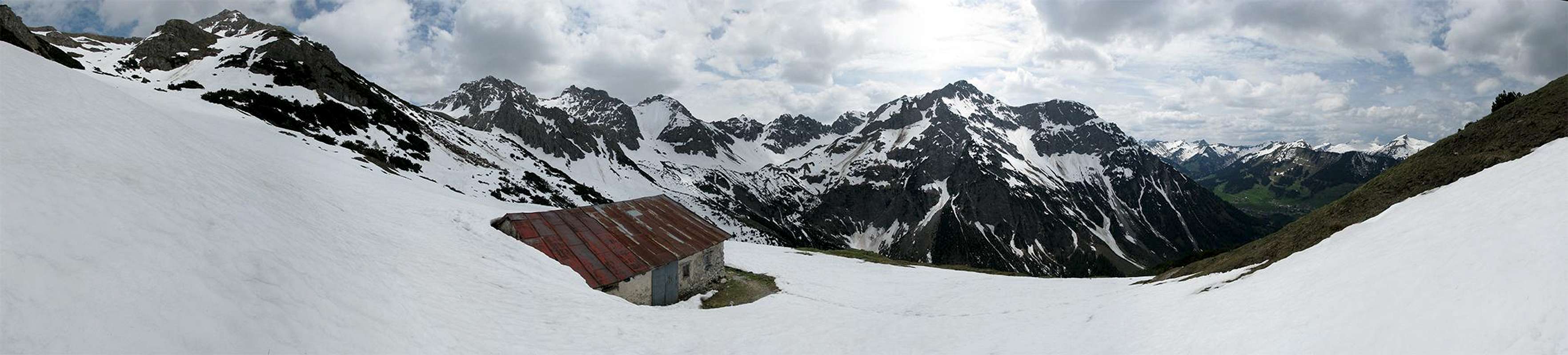
Hammerspitze offers two completely different sides. Looking at Hammerspitze from north or eastern directions, you see a steep and rocky face with a beautiful north-east ridge. To the south and west Hammerspitze has gentle grass slopes down into the Wildental, which are used for ski-touring during the winter months.
As well as its two sides Hammerspitze has two names which leads to a little trouble. Since the mountain is located at the border between Austria and Germany it has an Austrian and a German name. The problem with these names is, that the German Schüsser is the Austrian Hammerspitze, while the Austrian Schüsser is the German Hammerspitze (2260m/7415ft). So if you want to visit one of these mountains make sure at every sign that you' re hiking to the mountain yuo actually want to ascent...
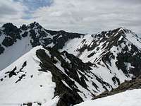 Hammerspitze from the ridge
The traverse of Hammerspitze from Kanzelwand (2058m/6752ft) is quite popular. There are mainly two reasons for that:
- You can use the "Kanzelwandbahn" cable car up to a height of 1880m/6168ft which eases the ascent from Riezlern (about 800m/2600ft of altitude difference). The cable car belongs to the ski area Kanzelwand/Fellhorn.
- The second reason is the beautiful ridge itself which is mostly walking but also offers some exposed parts and easy climbing sections.
Maps and routes overview
Maps:
Routes:
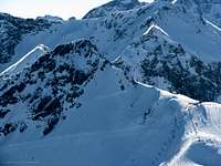
|  Impression of the north-east ridge. Impression of the north-east ridge. |
Panoramic views
  |
Mountain conditions
Weather:
Webcams:
|  Winterview Winterview |

Getting There
Despite of the route you choose to the summit you have to get to Oberstdorf first, since the valleys around Hammerspitze are accessible from Oberstdorf exclusively (even the austrian Klein-Walsertal).
By car:
Road B17 connects Oberstdorf and Kempten. From Kempten you have access to highway A7 leading north to Ulm. Additionally raod B12 is an east-west connection from Lindau to Landsberg. From Lindau it isn' t far to Austria and Switzerland, while Landsberg has a conenction to highway A96 to Munich. At Oberstdorf roads lead to Mittelberg and Faistenoy (watch out for the signs, I' ve been there only by train).
By train/bus:
Oberstdorf can be reached by train very well. For information about the train connections visit the website of Deutsche Bahn. If you' re coming from Munich I recommend to take one of the ALEX trains, because they don' t stop that much and the trains of the Deutsche Bahn aren' t much cheaper. Next to the train station is a bus station with buses leaving to Mittelberg and Faistenoy. During the winter months you don' t pay anything for the bus trip as long as you have ski equipment with you.
Red Tape
There are no permits, fees or seasonal closures. The german side of Hammerspitze is part of the nature reservation area Allgäuer Hochalpen (page in german only). Therefore don' t pick flowers and leave only footprints.
Parking at the trailhead is definitely not for free. Since the area is a ski-area there are big parking lots (both in Mittelberg and Faistenoy). If you have information about the prize, let me know.
Accomodation
There are no huts directly on the mountain where you can stay for a night. The only hut is the Fiderepass hut (2067m/6781ft) about 1.5-2h from the summit. Additionally the area around Oberstdorf is full of hotels and places to stay. For more information visit the multilangual homepage of Oberstdorf.
When to climb
Hammerspitze is usually climbed during the summer months. I don' t know how many people do the ski tour in winter. Since the slopes of Hammerspitze are reasonably steep there has to be a quite stable avalanche situation.