The lost hiker's last mile

Carole Wetherton and her daughter Kim Beverly disappeared in Western Uintas in September 2003. Their last camp was discovered by chance during an SAR training excercise the following summer, and the images saved from the dead women's camera told an eerie story of a half-day hike gone wrong. The images, made public three years after their death, also dispelled the investigators' theory.
![A streak of talus on the face of Notch Mtn]() Starting point of the photohunt at Hidden Lake - compare with the lost hikers' image
Starting point of the photohunt at Hidden Lake - compare with the lost hikers' image
In the few weeks remaining before the snow closed the area roads, I made three photo-hunt trips to the area, trying to reconstruct the lost hikers' exact route and fate. It gradually crystallized into an understanding that the pair took a wrong turn at Clyde Lake, descended towards
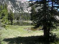
Hidden Lake (the dead hikers' last identified picture, right) on ever-fainter trails, and continued cross-country towards the gorge of Middle Fork Weber River, less than one mile to the West but a thousand feet lower.
Their last shelter, under a North-facing overhang of light-colored cliff, must be somewhere on the East side of the gorge.
Crisscrossing the terrain beyond Hidden Lake

The snow has finally melted, and we revisited the now-familiar area again, hoping to id the location of the "meadow with a distant mountaintop" shot (left), and to narrow down the area where the last rocky shelter may be located.
![Slopes between Mid Fk Weber and the base of Notch]() A latticework of rocky fissures, deep and long, may be where the hikers made their fatal stop
A latticework of rocky fissures, deep and long, may be where the hikers made their fatal stop
Firstly, we confirmed the location where their Hidden Lake picture was taken - including a very charasteristic streak of steep talus on the SW face of Notch Mountain in the background of the image.
![East aspect of Long]() The rounded summit of Long Mountain may be what's in the backdrop of the hikers' image?
The rounded summit of Long Mountain may be what's in the backdrop of the hikers' image?
Over the next three hours we kept zigzagging all across the area between Hidden Lake,
a small pond to the North, a
marshy depression to the South, and
a system of impressive rocky fissures to the West. The end result? Haven't found where the "meadow with a mountaintop" shot was taken. Not even sure yet which mountain is in the picture. The summit of Watson is somewhat more angular so it may be Long Mountain. A close comparison of our track with Google imagery shows that we missed two smaller meadows, will have to return to double-check. And the rocky outcroppings on the slope above Mid Fork Weber? It will take a good deal more footwork to complete the search there, but importantly, most of the cliffs there face East or West rather than North like in the SAR picture.
![Twins summits of West Notch Mtn]() Wonderful breeze above 11,000 ft
Wonderful breeze above 11,000 ft
The heat of the afternoon (100 degrees in the valley) was finally getting us, so we stopped for another skinny / furry dip in an unnamed lake at the base of West Notch, and escaped up to the breezy, snow-patched ridgeline of Notch Mountain, then ran down by Wall Lake (another dip!) back to the trailhead. I guess it will take another trip to sort this mistery out!
Comments
No comments posted yet.