
|
|
Route |
|---|---|
|
|
39.35110°N / 120.367°W |
|
|
Hiking |
|
|
Spring, Summer, Fall |
|
|
Half a day |
|
|
Overview
The Hole in the Ground Trail (HITG) is a biking/hiking trail that offshoots from Castle Peak Road up to the top of Andesite Peak. The trail is quite smooth and easy to follow. It provides some nice views of Castle Peak and the Donner Pass area. The summit of Andesite Peak, while only 8219 feet is a worthwhile effort. There are splendid views towards Castle Peak, Basin Peak, as well as Tinker Knob and the Granite Chief Wilderness to the south. Basin Peak from the summit of Andesite Peak
The total distance for this hike is only 4.5 miles round trip. It is about 1,000 feet of elevation gain to reach the summit. However, if that doesn't seem very interesting, there is another facet of this excursion that is worth noting. At the beginning of the Castle Peak Road, there are two large rock formations; basically piles of old volcanic rocks. These rock formations offer fun rock scrambling opportunities after the hike to Andesite Peak. These rock formations will be described in the final section.
Getting There
Andesite Peak is located about 10 miles northwest of Truckee, California. The parking area for this hike is a 45-50 minute drive from Reno, Nevada. The Hole in the Ground Trail is accessed via Castle Peak Road. To get to Castle Peak Road, take Interstate 80 to the Castle Peak / Boreal Ridge Road (exit #176). Once off the exit, head to the north side of the freeway. Follow a paved road as it winds up a small hill for about 1/4 mile where the dirt road begins. The elevation at the start of the dirt road is about 7280 feet.Route Description
Hike up the dirt road for about a mile until you see the sign for the "Hole in the Ground Trail" on the left. The trail is moderately steep as it switchbacks generally north and west until it heads east again. After about one mile from the start of the trail, Andesite Peak comes into view. Do not bushwhack up to the summit. Follow the trail until you can see Castle Pass. At this point, you have passed the summit, and it seems like you are going the wrong way. That is not the case. Pretty soon, there is a trail heading back towards the summit.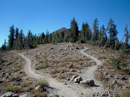 The turn around point on the Hole in the Ground Trail
The final summit trail is basically flat for a couple hundred yards until you reach the base of the summit rocks. Follow the use trail up about 180 feet of loose volcanic rocks to the Andesite Peak summit marker.
Rock Climbing Opportunities
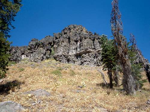
There are two large rock formations that can be accessed from the beginning of Castle Peak Road. Admittedly, these rock formations have nothing to do with the Hole in the Ground Trail. However, I find that the brevity of the Hole in the Ground Trail makes this a worthwhile addition. Scrambling these rock formations can be done easily after a hike up Andesite, adding a little over a mile and 350-500 feet of elevation gain.Both of these rock formations are located at the south end of the Andesite Ridge. The eastern rock formation is 7608 feet and the western rock formation is 7565 feet. The higher, eastern rock formation, is 328 feet above the start of the dirt road. It is not defined as a peak, although it could be referred to as "Point 7608".
 Approaching Point 7608
 Approaching Point 7565
It is simple to get to either of these rock formations. Shortly after Castle Peak Road turns to dirt, there is a left turn up another dirt road. This road leads up to the south face of both rock formations. A slight bushwhack is required to get to the base of each rock climb. The difficulty of climbing the rock formations ranges from an easy scramble to class III/possibly class IV moves if one chooses the most difficult route.
Interestingly, Point 7565 seems higher than its eastern neighbor, but the looks are deceiving. The views from either summit are spectacular.
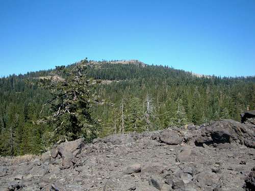 Andesite Peak from Point 7565
 Castle Peak and Basin Peak from Point 7608