
|
|
Hut/Campground |
|---|---|
|
|
44.94737°N / 6.38314°E |
|
|
Spring, Summer, Fall |
|
|
10400 ft / 3170 m |
Overview
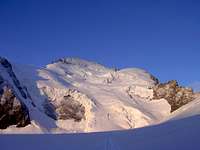
The hut is located at the relatively isolated area of the Écrins National Park. There is no ropeway to reduce the long hike to the hut. But so there is a wonderful impression of the nature, the mountains and the glaciers. From the hut you have several climbing possibilities and a great view to Pelvoux, Barre des Écrins and several other summits. You also have a great view back to the valley of Ailefroide.How to get there

The starting point to reach the hut is Ailefroide (1.503 m) or better Refuge Cézanne (1.874 m, a hotel) with a big parking place.
By train:
To l´Argentière-la-Bessé (979 m, 16 km south of Briancon). From there by bus 18 km to Ailefroide.
By car:
The motorway Bern-Genf-Grenoble, then the National Road 91 via de Col du Lautaret or from Torino via the E 13 Susa – Oulx – Col du Montgenèvre to Briancon and Ailefroide.
From Ailefroide on a really bad road with many potholes steeply upon. After 5 km you reach Refuge Cézanne.
From Refuge Cézanne on crushed rock, crossing a small wooden bridge (over the melted water of Glacier Noir). Then you ascend in loop lines on grassy mountain sides. This trail is always good marked. You pass the Glacier Noir and the South side of Barre des Ècrins which are located on the left side. Soon you reach the glacier tongue of Glacier Blanc. Then you have to climb on rocks which were grinded by the glacier. You pass the ruin of Refuge Tuckett and reach Refuge Glacier Blanc after 2-3 hours (2.550 m).
Then you ascend always on the right side of the glacier. You see the hut from a distance of ca. 2 km.
Time: 5 h from Refuge Cézanne / 1.300 Hm
Route possibilities
 Barre des Écrins Barre des Écrins |  Roche Faurio Roche Faurio | 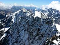 Pic de Neige Cordier + Montagne des Agneaux Pic de Neige Cordier + Montagne des Agneaux |
|---|
Barre des Écrins
Dôme de Neige
Pic Lory
Roche Faurio
Pic de Neige Cordier
Pointe Xavier Blanc
Pointe Louise
Montagne des Agneaux
(Mont Pelvoux)
.
More infos
Maps:TOP25 : 3436ET - MEIJE/PELVOUX/PARC DES ECRINS
Opening times: End of April to beginning of September
Reservation: obligatory
Hut operator: Laurent Vernet
Hut Telefone: 04.92.23.46.66
Sleeping places: 100
Coordinates GPS:
N / 4980.434 E / 293.543

Rafa Bartolome - Aug 27, 2012 4:43 pm - Voted 10/10
coordenadesyour coordinates are wrong. you can use the correct of some of my pictures (or you can find it easily with google maps because the path to refuge is visible)
schmid_th - Aug 28, 2012 10:19 am - Hasn't voted
Re: coordenadesHi Rafa, I changed the coordinates! Thanks for that info. Cheers Thomas