
-
 22128 Hits
-
 76.66% Score
-
 7 Votes
|
|
Hut/Campground |
|---|---|
|
|
43.20288°N / 4.81718°W |
|
|
Spring, Summer, Fall, Winter |
|
|
6407 ft / 1953 m |
Overview


Refugio de Vega Urriellu or Julián Delgado Úbeda.
Sotres (Asturias).
Situated under the W. face of the impressive Picu Urriellu / Naranjo de Bulnes (2519m) in the Central massif of Picos de Europa at 1950m.
Tel. 985 92 52 00
Web: http://www.picuurriellu.com/site/refugio.htm
mail: info@picuurriellu.com
Places: 96.
Services: water, toilets, showers, bar and service of foods, blankets, telephone and system of telecommunications for help.
Open: all the year!
Propietary: Principado de Asturias.
Management: Federación Asturiana de Montañismo
Routes of approach:
-Cable de Fuente Dé
-Collado de Pandébano
Getting there:
-Approach to Sotres from Santander: A-67 Torrelavega-Oviedo. Exit 272 to Unquera-Panes-Potes-Parque Nacional Picos de Europa. In Panes N-621 to Arenas de Cabrales-cangas de Onís. In Arenas de Cabrales AS-264 to Sotres.
-Approach to Fuente Dé from Santander: In Panes N-621 to Potes. CA-185 to Camaleño and Fuente Dé.
From Sotres-Pandebano: From Sotres you'll take the track signaled as Urriellu-Aliva some meters before the village. The track goes across Cabañas del Texu to the col of Pandebano (1100m) with parking.
Time of walking: 3h. Slope to gain: 910m. Signaled with paint white and yellow.
From Fuente Dé: from the upper station of Cable (1850m). The route is the same of Collado de Horcados Rojos (2360m) descending from this point to Jou de los Boches and Canal de Lebaniego to the refuge.
Time of walking: 3h. Slope to gain: 400m. Note: in the return you must ascent another 400m to the Collado de Horcados Rojos.
Climbs and traverses
Traverses:Refugio del Jou de los Cabrones (2035m), Bulnes (600m).
Walks:
Horcada Arenera
Climbs: with its gradation of normal route.
 Picu Urriellu (2519m): D.inf.
 Peña Castil (2444m): F
 Neverón de Urriellu (2559m): P.D.inf.
 Neverón de Albo (2445m): P.D.sup.
 Torre de la Párdida (2596m): F
 Torre de Coello (2584m): F
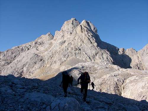 Torre Cerredo (2648m): P.D.
 Pico de los Cabrones (2553m): A.D.inf
 Torre de Horcados Rojos (2506m): F
 Tesorero (2570m): F.sup.
External Links
madteam-refugio V.Urriellu: information in Spanish.picosdeeuropa.net-refugios: list of refuges of Picos de Europa in Spanish.
trotamundos-route: images of the route to Refugio with text in Spanish.