
|
|
Mountain/Rock |
|---|---|
|
|
25.24942°S / 48.80657°W |
|
|
Campina Grande do Sul |
|
|
Hiking, Mountaineering, Trad Climbing, Big Wall |
|
|
Winter |
|
|
6060 ft / 1847 m |
|
|
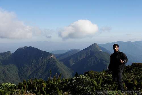
Me at the summit of Ibitirati. Behind me Taipabuçú (3 summits) and Ferraria peaks

INFORMATIONAL VIEW
Ibitirati Peak: 1.847 m
Paraná Peak (highest peak at brazilian south region): 1.877 m
Camelos Peak: 1.604 m
Agudo de Cotia Peak: 1.630 m
Ciririca Peak: 1.720 m
Caratuva Peak: 1.850 m
Taipabuçú Peak (3 summits): 1.732 m (highest)
Tucum Peak: 1.736 m
Camapuan Peak: 1.706 m
Ferraria Peak (i'm standing on its summit): 1.754 m
They're not big, but quite challenging mountains!
Brazilian state: Paraná.
Nearest big city and airport: Curitiba (40km)

Getting There
Take BR-116 to North till Campina Grande Do Sul, and search for Posto do Tio Doca (Tio Doca Gas Station). Ask for directions to get to the Pico Paraná Farm. From that farm is the starting point to the trail to some mountains of Ibitiraquire range. The trailhead is behind of a sign that says “Pico Paraná” with some geological info and maps on it. There aren’t bifurcations and follow the main trail to the summit, passing by crests and valleys and a lot of tree roots. The total distance of Pico do Paraná summit from the farm farm is 8 km.For ibitiraquire peak, there is two ways, hiking up from the summit of Paraná Peak, or rock climbing.
That's the info for the rock climbing:
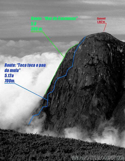
Rock climbing routes to Ibitirati Peak
First route: Mar de Caratuvas. It starts with a hard approach trail that can take up to two days. After that, rock climbing, not hard.5.8. 380 m.
Second route: Toca toca o pau da mula. Done at 2008 and never repeated. One day for the approach and two to three nights at the big wall. The actual rock climbing starts after around 100 meters of ascent by an easy 5.6/ 5.7 route. After that, put your game face on, more 600m of 5.12a route with two bivy spots. To more details about the route, the trip report for the brazilian climbers who conquered the route: http://altamontanha.com/colunas.asp?NewsID=350. It is in portuguese but if you want to, use the google translator!
Red Tape
No taxes to climb the mountain (for rock climbing route);For the hiking route, R$ 15,00.
Parking lot at the farm just before the trailhead;
Well marked trails;
What’s forbidden:
To make fire; Deforest any places. Respect the nature and wildlife please!
Camping
Camping god at these places:1 - The farm, Paraná Peak farm;
2 - Camp 1 to Paraná Peak;
3 - Camp 2 to Paraná Peak;
3 - Summit of Paraná Peak.
Legal Issues
To hike/ climb is a dangerous activity and requires proper equipment and clothing, the owner of this page cannot be blamed by injuries caused to anyone who read this page for its info about the mountain, and eventually got hurt by doing so with reckless behaviour or bad weather conditions.
Paulo Roberto Felipe Schmidt – AKA: PAROFES
External Links
My youtube channel: www.youtube.com/parofes - Now with 270+ videos online!The biggest brazilian website about climbing and mountaineering, for which I'm a columnist: