
|
|
Route |
|---|---|
|
|
19.23041°N / 98.03178°W |
|
|
Hiking |
|
|
Spring, Summer, Fall, Winter |
|
|
Most of a day |
|
|
Class 3 |
|
|
Strenuous hike |
|
|
Overview
La Malinche is most often climbed from the Centro Vacacional which is situated and easy to reach on its western slopes. However, there are a couple of others routes on the opposite side of the volcano, that offer quite a different and more spectacular view, with Pico de Orizaba and Sierra Negra watching your back on clear days. Climbing from this side you see the actual summit the whole climb once above the tree line, unlike climbing from the other, where you don't see the real summit untill you've reached the false one. This climb starts from the village of San Juan Ixtenco. For sure you will have this side of the volcano for yourself. I would recommend descending the eastern slopes, down to the Centro Vacacional, it is a quick descent, and doing so you get to see both sides of the volcano. You might just make it in time to catch the last bus back to Apizaco at five o'clock. If not, someone will give you ride.
 The East Face.
What remains of the crater lies on the eastern side so going up this way you get to see the vertical walls of the remaining crater. Not that I did go up these walls, but it is a steep hike up the heavily eroded slopes onto the rim from where it's another two hours to the summit, making it a total of about five hours from the trailhead. Going down the other side takes about three hours, so it makes for a full day.
 The crater.
Getting There
Get to Huamantla first. It's a nice little colonial town, one of the 'pueblo magicos' that attract quite some visitors, mainly during its annual bull run through the streets of the center of town. From here, take a collectivo to San Juan Ixtenco. It take about twenty minutes (five pesos). Get off at the main square (the main road connecting Huamantla with Puebla passes by here, right through the middle of town). From here you could walk to the trailhead in about three hours, starting a Calle Ponce d'Leon, which starts from the main square. It turns into a broad dirt road after half an hour. On your right you will pass the 'Cerro Xalapazco', which is an extinct volcanic field with nine craters, four of them quite big, one of them with a cave which, according to a local legend, has arms and gold burried in it, dating back to the revolution. Beware, there is a big bee nest at the entrance! If you want to hike this cerro, you will pass an old hacienda (hacienda de San Cristobal), which are just ruins now, a strange place.
 View from Cerro Xalapazco with one of its nine craters in front.
At the end of the dirt road from Ixtenco you will reach at ranger station of the Parque Nacional La Malinche, where you need to register (just your name and nationality, no entrance fee). There are few cabins here, and although they are not really operational (no beds), if you have your sleeping bag and pad with you, you could crash here for the night. I'd consider this the trailhead. If you don't want to walk untill here, you could ask any of the minibus driver at the main square of Ixtenco to take you. I was asked 150 pesos, but bargained down to 120 in the end. It took us 45 minutes to get to the ranger station on the bumpy dirt road. The road goes on a bit, but only locals checking water pumps and scientist working at the reasearch station up the road are aloud to go by car.
 Cerro El Filete with the research station.
Route Description
If you look at La Malinche from San Juan Ixtenco, you will see a big hill in front of it, the 'Cerro El Filete'. When I asked about the route in the village, everybody told me I had to go right of cerro el Filete, then turn left behind it, go up this way on the heavily eroded slopes untill you reach some 'arenales' (a flat grassy area) and then climb to the right to reach the summit. In the photo below, the horizontal line cutting through the trees is the road to the ranger station that turns into a trail.
 View of the East Face from Cerro Xalapazco with Cerro El Filete in front.
There are other trails that go to the left of Cerro El Filete, this way avoiding the steep eroded climb, that also take you to the flat area.
Starting from the ranger station, you will see a research center on your left after some twenty minutes. After about 45 minutes you will reach a dry river bed. You could walk into it, or follow the trail. At one point you need to turn left. I you keep going to far, you will end up at the crater, from where you can't go up because of the steep walls. Now to turn left, there are mainy trails. I would say, don't go left to early, or you will go up and down the back of the Cerro El Filete. Go far enough behind Cerro El Filete, so you can have a nice but rather steep hike up the eastern slope, but not to far, so as to avoid the crater.
 Looking back after coming from the right and bit lower than this point.
This part might take you two hours. So between 3 and 3,5 hours from the trailhead to the rim. There is a little unnamed peak at the rim from where it goes down a bit towards the flat grassy area. From here it is another two hours to the summit.
 The summit with two smaller peaks to its left.
You will see two smaller peaks left of the summit, and going up, you will end up between the one most left and the second one. You can easily get over the this one, and then reach the summit. To get up the summit it is a bit of a scramble, you will need to pull yourself up some rocks.
 The summit.
Essential Gear
Proper hiking boots, trekking poles at all seasons. During the months of December, January, February you need to take crampons. So whenever the volcano is snowcovered, keep in mind it is not snow, but ice! Because the sun melts the ice on these eastern slopes, those parts that receive sun can be done without crampons. Those parts that remain in the shade are hard ice where you need crampons.
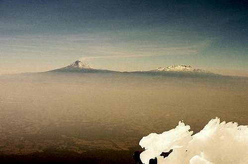 View of Izta and Popo from the summit.