
|
|
Route |
|---|---|
|
|
44.76190°N / 121.78744°W |
|
|
Hiking |
|
|
Summer |
|
|
One to two days |
|
|
Moderate |
|
|
I |
|
|
Overview
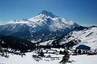 View from Park Ridge ( via the Breitenbush Trailead).
This climb to the meadows beneath Mt. Jefferson is tough, but the views make the effort worthwhile.
Oregon's second tallest mountain rises like a wall from the lake-dotted wildflower meadows of Jefferson Park. The view of Mount Jefferson is so impressive and the meadows are so delightful to explore that the area is crowded in summer - so why not wait to go until September?
-William Sullivan
Getting There
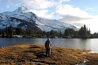
 View from Russell Lake in October
There are a few trailheads reaching into the park, my favorite and the least used is from Breitenbush lake.
From Salem drive East on Oregon Highway 22 for 50 miles to Detroit. Turn left onto paved foerest 46, following signs to Breitenbush, and drive 16.9 miles to a junction with forest road 4220. (From Portland you can reach this junction more quickly by driving 55 miles south east of Estacada on Hwy 224 and forest road 46.) Turn east and drive 1 mile to a gate, where the gravel road changes to dirt. The road is passable in most vehicles if the weather is good (no snow & not to wet). The trailhead is 5.5 miles from the gate, there is a large parking area and restrooms.
There is no parking fee from this trail head.
-Dan F.
Here is another route:
From exit 253 of Interstate 5 in Salem, drive 61 miles east on North Santiam Highway 22. Between mileposts 60 and 61 (10 miles beyond Detroit), turn left on Whitewater Road 2243. Follow this gravel route 7.4 miles to its end at a large parking area. Especially if you're leaving your car here overnight, leave no valuables inside and leave doors unlocked to discourage car clouters, an occasional problem here.
Fees: A Recreation Fee Pass (Northwest Forest Pass) is required to park here. The pass costs $5 per day or $30 per season
-William Sullivan
Route Description
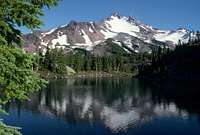
 There are many ponds in the park during the Spring and Fall
From the parking area, the well-graded trail starts in an old-growth Douglas fir forest. Gradually you'll switchback up into a higher-elevation forest of true firs and beargrass. After 1.5 miles, turn right at a trail junction on a ridgecrest.
Breathtaking views of Mount Jefferson open up as the path climbs east along the ridge. At the 3.9-mile mark, a footbridge crosses Whitewater Creek in a meadow with shooting star, larkspur, and bleeding heart. At the Pacific Crest Trail (PCT) junction, turn left.
For the next 0.9 mile the trailside meadows become larger and prettier until the path reaches Jefferson Park - a vast plateau of heather, red paintbrush, lupine and clumps of wind-gnarled mountain hemlock. Here, unfortunately, a confusion of trails proliferate - left to Bays Lake, right to the head of Whitewater Creek. To follow the PCT, keep straight to the first glimpse of Scout Lake, then veer right.
One way to explore the area is to follow the PCT 0.7 mile across the park to large Russell Lake and return cross-country, either south through the heather or southwest to find the hidden lakes. Though chilly, these sandy-bottomed pools are among Oregon's most beautiful spots for a quick swim.
-William Sullivan
Camping
 Great views
 Designated camping area.
 The Forest Service Requires all campers to do so only in marked areas (marked with a post). Because of the popularity of the area expect that the rules will be enforced. There are some pretty good spots but they will be hard to access in the summer when he park is crowded.
Fires are banned.
Dan F.
Geology
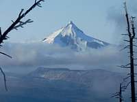
Mt. Jefferson is an apparently extinct volcano that has lost about a third of its original size to the erosion of glaciers. More than once, glacial lakes high on the mountain's north slope have breached their sand dams, flooding Jefferson Park. The result is a relatively flat, sandy plain with large open areas.
-William Sullivan