
-
 8756 Hits
-
 89.01% Score
-
 28 Votes
|
|
Route |
|---|---|
|
|
34.45437°N / 119.72881°W |
|
|
Hiking |
|
|
Spring, Summer, Fall, Winter |
|
|
Half a day |
|
|
Overview
 Looking at the Pacific Ocean from Inspiration Point
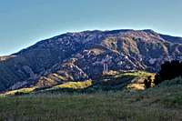
Jesusita Trail is an alternate route to reach Inspiration Point in the Santa Ynez Mountains of Los Padres National Forest, California.
Because of its ease of access and consistently gentle grade, Jesusita Trail is extremely popular with mountain trail runners. The trail rises some 1225 feet in 3.5 miles and there are only a few short steeper sections. This trail also attracts nature lovers high in their age group.
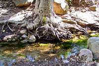
In 2009 a huge forest fire ravaged much of the mountains north of Santa Barbara. The origin of the fire was traced back to the Jesusita area. After three years of recovery, there is little evidence of charred landscape around there to be noticed. Instead, there are millions of wildflowers covering the hillsides and several larger and smaller running creeks. At the end of your pleasant hike, you are treated to a breathtaking view of the city of Santa Barbara, the Pacific Ocean and Channel Islands National Park.
 |  |  |  |
 |  |  |  |
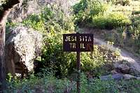
Jesusita Trail

 Ranch Road
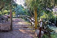 Unlocked gate
The trail starts near the end of San Roque Road, across from Lauro Reservoir. There are trails and warning signs about fire danger, as well as some trash cans. The trail drops down a few hundred feet, but eventually it begins to rise again. The trail mostly parallels Jesusita Road and a running creek down Lauro Canyon. Stay to the right indicated by trail signs. Ignore all side trails going toward the creek and stay on the main trail. Your first major junction is with Arroyo Burro Trail. After about three quarters of a mile, you reach a gently sloped meadow and a view of Arlington Peak area. There are several smaller creek crossings and many trail signs to keep you on the right track, and out of private properties.
After a creek crossing by a private bridge you will be walking on paved road that leads to a huge locked gate. There is a smaller unlocked gate on the right for hikers to get through. The ranch owners have gone to great length to provide shade and a resting spot for tired hikers. They have also provided water for horses and dogs. Past the gate continue walking on paved road for a short distance. Another trail marker will direct you to the Jesusita Trail again. Continue on the trail until it joins the service road/Catwalk by power lines. Just past the power lines towers look for an old sign to your right, ocean side. Follow that trail walking near the top of the ridge to Inspiration point. If you miss the old sign, you can continue on the catwalk to the high point of the ridge. Then, go through a short grass covered hill to Inspiration Point. The views from here are mesmerizing.
--------------------------------------------------------------------------------------
 |  |  |
Getting to the trailhead
 Trailhead
Coming from the south or north, take Las Positas exit on Highway 101 in the city of Santa Barbara and turn toward the mountains, north. Go about a mile to reach State Street. Cross State Street and note that the name of Las Positas changes to San Roque Road. Go through two stop signs in one mile to Foothill Road. Continue going straight crossing Foothill Road. About .4 miles from the junction of Foothill and San Roque you will see the trailhead on the left across from Lauro Water treatment/Reservoir. There is a small parking area for about six cars by the trailhead. You can, however, park on the road across from the trailhead.