Welcome to SP!  -   
 
 New features are here! - Read More... 
Areas & Ranges·Mountains & Rocks·Routes·Images·Articles·Trip Reports·Gear·Other·People·Plans & Partners·What's New·Forum

June 25th, 2005 - The routes...

 
[ Sizes: Orig | Small | Thumb ]
June 25th, 2005 - The routes...
June 25th, 2005 - The routes left of Lisa Falls seen during the height of spring runoff when Lisa Falls was actually pouring down part of the routes!. These ones are mostly runout and are often top-roped. The left route is Lisa Falls Left (5.8 R) 
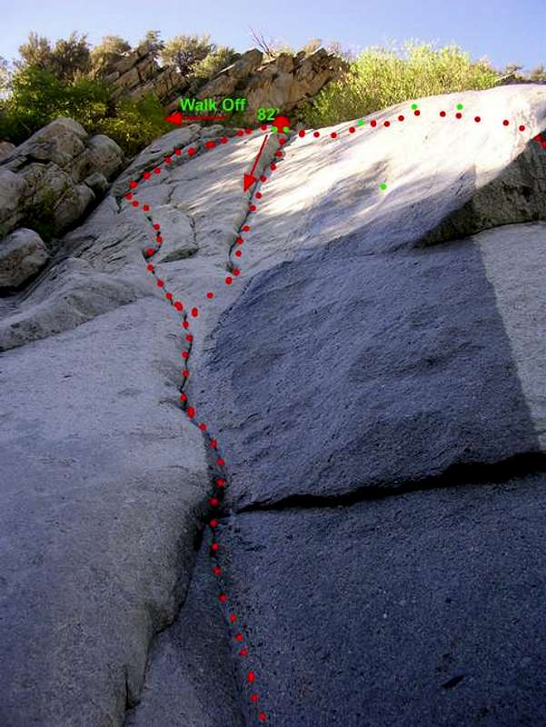
, the center one is Sweet Spot (5.8+ R) , and the right one is Sweep Left (5.10b) . The lone bolt protecting Sweet Spot is in the middle of the face.


Key:
Dot = route
Circle & Dot Pairs = Chained Anchor
Dot = bolt


Comments

No comments posted yet.


Sign in to post!

Don't have an account? Register now.


Rate This Image
Current Score: 86.25

Log In To Vote
 Lisa Falls (Mountain/Rock)

July 3rd, 2005 - The main...
« PREV

Viewing
#3 of 9
GALLERY
July 3rd, 2005 - The routes...
NEXT »

 PellucidWombat's Image Gallery

July 3rd, 2005 - The mouth of...
« PREV

Viewing
#1343 of 2321
GALLERY
July 3rd, 2005 - The routes...
NEXT »


 Little Cottonwood Canyon (Canyon)


Image Data

PellucidWombatSubmitted by PellucidWombat
on Jul 7, 2005 4:57 pm

Image ID: 113855
Hits: 1404 

Lat/Lon: 40.57310°N / 111.7761°W


"Those who contemplate the beauty of the earth find reserves of strength that will endure as long as life lasts"   --Rachel Carson   

© 2006-2012 SummitPost.org. All Rights Reserved.