
-
 5042 Hits
-
 81.18% Score
-
 13 Votes
|
|
Mountain/Rock |
|---|---|
|
|
47.40267°N / 11.45078°E |
|
|
Hiking, Mountaineering, Trad Climbing |
|
|
Summer, Fall |
|
|
8967 ft / 2733 m |
|
|
Overview
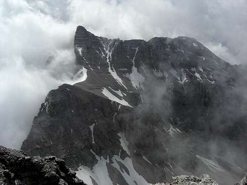
 Her Majesty, the Queen of Karwendel
Some call Kaltwasserkarspitze the “Queen of Karwendel”.
Other call it “Arrogance in stone”.
Well, queens sometimes have to be arrogant.
Standing in the very center of Karwendel, southeast of Birkkarspitze, the highest Karwendel peak and “her king” and west of Rauhkarlspitze, Kaltwasserkarspitze is the most wanted summit for Karwendel peak baggers. Despite of being the 4th highest peak within Karwendel, Kaltwasserkarspitze looks so bold and keen when viewed from the west or east and you think, this is a must-have summit.
The north face drops more than 1300 m down to Kleiner Ahornboden and the summit block shown an immense upsurge which might be the explanation for the marking as “arrogant”.
But every queen has her soft sides, too, even when being arrogant – sorry for that, ladies – and this soft side is the long and huge south ridge down into Hinterautal, a sort of royal train, dividing the Birkkar valleys to the west from Moserkar valley to the east. This south ridge bears the easiest route to Kaltwasserkarspitze.
 The arrogant side of the Queen The arrogant side of the Queen |  The soft side of the Queen The soft side of the Queen |
Kaltwasserkarspitze belongs to the Hinterautal – Vomper ridge, the main and highest ridge of Karwendel. The first confirmed ascent was by Hermann von Barth on august, 15th, 1870. He used the south ridge route for his successful attempt, despite of a heavy snow storm.
 Summit view to the northeast
An ascent of Kaltwasserkarspitze is always a very long day. As there is no possibility for an overnight stay (with the exception of an illegal bivvy night) you have to combine hiking with biking to manage this outing as a one day undertaking. The bike route to Kastenalm is about 15 km long, one way! The ascent from Kastenalm to Kaltwasserkarspitze is 1500 m of altitude difference and another 6 km long (south ridge), again one way.
The Queen is not only arrogant, it takes a royal effort to conquer her!
Getting There
The best trailhead for Kaltwasserkarspitze is Scharnitz.You reach Scharnitz by car:
 Birkkarspitze and Kaltwasserkarspitze Birkkarspitze and Kaltwasserkarspitze |  Summit view to Birkkarspitze Summit view to Birkkarspitze |  The old summit register of the late 80th The old summit register of the late 80th |
At the church near Isar bridge take Hinterautalstraße in southern direction. After the undergrade passing of the railways you reach a huge parking area to your left (fees!). 300 m further on there is another small parking area after the bridge across river Isar to your right.
Scharnitz can be reached with railway, too. See the railway schedule here.
For the unusual north ascent to Kaltwasserkarspitze you have to start at Karwendelhaus (overnight stay).
The Karwendelhaus ascent from Scharnitz uses the long Karwendeltal road up to Hochalmsattel, the col between Birkkarspitze and Östliche Karwendelspitze where the huge mountain hut is located. MTB is nearly a must (otherwise 13 km walk!).
 Hinterautal / Gleierschklamm Hinterautal / Gleierschklamm |  Hinterautal / Reps summit Hinterautal / Reps summit |  Hinterautal in early morning Hinterautal in early morning |
Karwendelhaus can be reached, too, from
Route Overview
Main Routes Overview
Approach Scharnitz – Kastenalm
This is the bike part of the tour.
Starting at Scharnitz parking areas follow the first paved road across the Isar bridge to Schönwieshof inn. Bike up the steep ascent, no unpaved, to Gleierschhöhe, were the forest road to Amtssäge, Möslalm branches off to the right. Go straight on and descend slightly into Hinterau valley. Follow the good road (number 224) with a moderate grade up to Isar wells and to Kaser hunters cabin.
 Kastenalm Kastenalm |  Starting point of south ridge route Starting point of south ridge route |
The forest road goes on to the right to Halleranger Haus.
For the Hochjöchl route leave your bike around Kaser hunters cabin.
For the south ridge route go straight on on another forest road which turns right after some 500 m and left again at the Kastenalm meadows. This rather bad forest road enters then Roßloch. Leave your bike near the confluence with Moserkar valley.
Hochjöchl route
200 m before you reach Kaser hunters cabin / Kastenalm, trail number 225 branches off to the left into Birkkar valley. Ascend on the trail left / east of Birkkarbach until you reach some springs.
Above those springs, at about a height of 1750 m, a barely visible foot track branches off to the right into Östliches Birkkar, above and west of the creek coming out of that valley. Follow this foot track and later on off trail, ascending to Hochjöchl, the lowest point between Birkkarspitze to the west/left and Kaltwasserkarspitze east/right. It is marked as point 2411 m on the Alpenverein map.
 Birkkarspitze and point 2552 m as seen from the summit Birkkarspitze and point 2552 m as seen from the summit |  The chute system (snow) and point 2552 m, the ascent route is the middle chute going up to the south ridge The chute system (snow) and point 2552 m, the ascent route is the middle chute going up to the south ridge |
At the col turn southeast and traverse upward some steep slabs south / below the ridge crest. Follow then the ridge near the ridge crest over steep rocks with some UIAA grade II moves exposed (!!) to point 2552 m (Alpenverein map).
There is a foot track again, ascending southeast below Kaltwasserkarspitze summit block into a system of chutes running down from the south ridge of Sägezähne. Take the leftmost chute for the ascent; this chute ends at the last notch between Kaltwasserkarspitze summit block and Sägezähne, the uppermost rock bumps of the south ridge.
Follow the easy rocks and some foot tracks in the scree up to the summit.
South ridge route
This can be named the normal route to the summit. It is the easiest route and the most frequented – mind: the summit isn´t frequented at all (see the small summit register of 1987; about 2/3 of the register was full in 2016)!
 Unbenannter Gipfel, Moserkarspitze, Kühkarlspitze and Sonnenspitzen as seen from the trail of the south ridge route Unbenannter Gipfel, Moserkarspitze, Kühkarlspitze and Sonnenspitzen as seen from the trail of the south ridge route |  Kleiner Heissenkopf ( south ridge route; view to Praxmarerkarspitzen (left) and Hoher Gleiersch (right) Kleiner Heissenkopf ( south ridge route; view to Praxmarerkarspitzen (left) and Hoher Gleiersch (right) |
Follow the forest road from Kastenalm into Roßloch until the road touches the scree field of the Moserkar creek and the runoff out of Roßloch. Look out for a cairn on the other side of the scree field.
Cross the runoff at the cairn and enter the dwarf pines zones. A trail leads first east then north and starts to climb up a slope called Moserkaregg into woods.
 Moserkar view Moserkar view |  The K.S. mark at the route junction The K.S. mark at the route junction |  Ascent to Kleiner Heissenkopf Ascent to Kleiner Heissenkopf |
Follow this trail, it is the route into Moserkar and the summits Kühkarlspitze, Moserkarspitze, Rauhkarlspitze and Unbenannter Gipfel.
When you leave the woods and reach the dwarf pine zone again the trail levels out at a viewpoint into Moserkar. From there on follow the trail for about 100 m and then look out for some red dots and a barely visible foot track on your left. Turn on this foot track and follow the red dots – after 200 m there is a red “K.S.” on a rock – into the steep east slopes of Kleiner Heissenkopf. After some easy rocks and zigzags the trail starts to become more clearly and distinct. It winds itself up in endless zigzags and then starts to traverse in southern direction along some inclined rock faces up to a level part between Kleiner Heissenkopf and Großer Heissenkopf.
 Großer Heissenkopf Großer Heissenkopf |  Descent marks at Kleiner Heissenkopf - important!! Descent marks at Kleiner Heissenkopf - important!! |  Around Grosser Heissenkopf Around Grosser Heissenkopf |
This part, about 2000 m high, is crucial if you are descending this route: There are many red dots and a red arrow marking the beginning of this trail. Follow closely these marks when descending! There were many fatal accidents in this area as the south faces of Kleiner Heissenkopf are near perpendicular and you need to reach the trail to get safely down to the valley ground.
Follow the meadow ridge and then the easy scree and rock ridge up to Großer Heissenkopf, 2435 m and big cairn. The ridge gets more sharp then, follow it over easy rocks into a notch in front of a steep ridge part, which leads easy up to the first of the Sägezähne, several rock bumps within the south ridge to Kaltwasserkarspitze. You reach the first bump over scree, easy rocks and slabs, sometimes left / west of the ridge, sometimes on it. Shortly before you arrive at the first Sägezahn you will have a first view of the still rather distant summit.
 Sägezähne Sägezähne |  Sägezähne ridge Sägezähne ridge |  Sägezähne ridge Sägezähne ridge |
Follow the scree and rock ridge in some ups and downs until it drops down steeply to a notch. Leave the ridge there to your right / east, turn south and descend on a ledge until you can turn north again and follow another ledge into the notch. There are some easy grade I moves before you arrive at the notch.
Ascend steeply back to the ridge crest (grade I) and follow the ridge on good and easy slabs until you arrive at a second drop down to the next notch. Go right / east again and follow slabs and some rocks on the east side of the ridge into the notch.
 Traverse of Sägezähne, Kaltwasserkarspitze summit in the background Traverse of Sägezähne, Kaltwasserkarspitze summit in the background |  Traverse of Sägezähne Traverse of Sägezähne |  First narrow notch with steep ascent to the next Sägezahn (grade I) after the first eastern bypass First narrow notch with steep ascent to the next Sägezahn (grade I) after the first eastern bypass |
Cross the notch to the left / west side and descend 5 m into the chute, running down from the notch into Östliches Birkkar. Leave the chute immediately in southern direction gaining a very narrow ledge which bypasses the last of Sägezähne. You soon will find some cairns on this bypass which ends at the last notch where the Hochjöchl route gains the south ridge.
You can traverse this last Sägezahl directly on the ridge crest, too; then there are some grade III – moves to master!
 Ledge system of the western bypass of the last Sägezahn Ledge system of the western bypass of the last Sägezahn |  Ledge system of the western bypass of the last Sägezahn Ledge system of the western bypass of the last Sägezahn |  Last notch between Sägezähne and Kaltwasserkarspitze Last notch between Sägezähne and Kaltwasserkarspitze |
Follow the easy rocks and some foot tracks in the scree up to the summit.
 Deep view into Hinterau valley
Other routes
 First eastern bypass with short grade I scramble - south ridge route First eastern bypass with short grade I scramble - south ridge route |  On the west bypass of the last Sägezahl (grade I / II), view to the south On the west bypass of the last Sägezahl (grade I / II), view to the south |  Sägezähne as seen from the last ascent to Kaltwasserkarspitze summit Sägezähne as seen from the last ascent to Kaltwasserkarspitze summit |
Ski route
(only for very experienced ski mountaineers!)
In springtime with good snow cover and secure avalanche conditions:
From Östliches Birkkar (Hochjöchl route) ascending the west chutes directly up to the south ridge (~50° slope gradient!).
Red Tape & Accommodation
 Wonderful Papaver sendtneri as seen on the south ridge route
Red Tape
Kaltwasserkarspitze is part of the “Alpenpark Karwendel”, an important and strictly protected national park.
There is no entrance fee for the park but many regulations to follow.
Please respect the following rules in the National Park:
There is a National Park Information Center at Scharnitz and Hinterriß.
The parking areas at Scharnitz require a parking fee!
 Kaltwasserkarspitze north face as seen from Eng valley Kaltwasserkarspitze north face as seen from Eng valley |  Dangerous snake? Surprise on an early morning ascent Dangerous snake? Surprise on an early morning ascent |
Accommodation
Food and lodging can be found at
Camping is not allowed within Alpenpark Karwendel.
Mountain huts
 "Cairn city" of Hinterautal "Cairn city" of Hinterautal |  Summit view to the west with Zugspitze and Seekarspitze Summit view to the west with Zugspitze and Seekarspitze |
Gear & Mountain Condition
 View to the Halltal ridge from Kaltwasserkarspitze south ridge
Kaltwasserkarspitze normally is a summer and early autumn undertaking. It is in both main routes a long and strenuous outing.
There is no overnight possibility for Kaltwasserkarspitze on the two main ascent routes!
First of all you need a bike to go from Scharnitz to Forsthaus Kasten unless you like to walk 15 km one way.
For the two main ascents you need hiking gear, good boots and lots of water. Belaying normally is not possible so you need no rope or belay items. The rock difficulty never exceeds grade II. Mostly its grade I and scrambling.
A helmet, crampons and an ice axe in early summer, especially for the Hochjöchl ascent is recommended.
The few climbing routes require a rope and climbing gear. The rock is frail and the routes are not very frequented.
Current Weather:
Maps & Guide Books
 The appearance of the Queen as seen from Marxenkarspitze The appearance of the Queen as seen from Marxenkarspitze |  Kaltwasserkarspitze (left) and Birkkarspitze as seen from Östliche Karwendelspitze Kaltwasserkarspitze (left) and Birkkarspitze as seen from Östliche Karwendelspitze |
Maps
Alpenvereinskarte 1 : 25.000
Blatt Nr. 5/2, Mittleres Blatt
Online Shop Deutscher Alpenverein
For the Karwendelhaus ascents you need:
Alpenvereinskarte 1 : 25.000
Blatt Nr. 5/1, Westliches Blatt
Online Shop Deutscher Alpenverein
Bayerische Topographische Karte 1 : 50.000
Karwendel, UK 50/51
Landessamt für Vermessung und Geoinformation, München
 Kaltwasserkarspitze and Sägezähne Kaltwasserkarspitze and Sägezähne |  Lafatscher ridge as seen from Hinterautal/Kastenalm Lafatscher ridge as seen from Hinterautal/Kastenalm |
Guide Books
Walter Klier
Alpenvereinsführer Karwendel alpin
Bergverlag Rother, München
for rock climbing:
Walter Klier
Alpenvereinsführer extrem
Bergverlag Rother, München
(out of stock)
Available only in German