
|
|
Route |
|---|---|
|
|
28.85500°N / 90.20420°E |
|
|
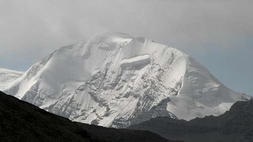
Mountaineering |
|
|
Expedition |
|
|
Class 3 |
|
|
High Altitude |
|
|
Kaluxung – short history, my experiences and overview
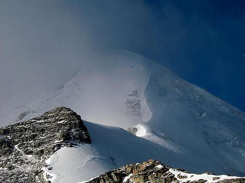
 The huge cornice at the end of the ridge
Kaluxung has been climbed three times. Those climbs has all been done via the North East Glacier. First by a Japanese team in 2005, which is exceptionally late for a peak of Kaluxung’s altitude and it’s even more remarkable as there’s a good road at the very foot of the peak. The second climb was done by Germans. The third ascent was made by Bruno Tibet in 2007 via the same route. In the winter of 2008 two Summitposters went to the peak. Butterfly made a recce on the NW ridge, but made no progress in hard winter winds. We then went for the N ridge. Very rough weather stopped us on the beginning of the ridge.
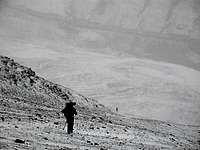 1. Heading up steep gravel from the road
Some weeks later we went back, but both Butterfly (has left SP) and Thorsten (SP nick forgotten) gave in to illness and the rough weather. I made a solo attempt in full storm, but found it smart to turn back at 6560m after almost been blown off the ridge at several occasions. Because of that I can’t give you the full route, but as far I could judge the most technical parts were done and the rest of the route I couldn’t make seemed to be a quite straight forward walk. That said, it seemed to be some danger of crevasses, but I’m not sure. Be careful beyond what's described below.
The route.
Altitude gain from the road – about 2000 meters depending on where you start from.
Length of route.
From the road: 5,5km
From "BC" in the valley (5500m): Approx. 4km.
Overview.
A scramble from the road on steep and nasty gravel and rock. Some loose, but easy rock scrambling onto the snow fields. Steep parts on a narrow, windy and exposed ridge. Some hidden and some visible crevasses en route. The final part is a high altitude snow walk to the summit.
 2. On the saddle in the beginning of the ridge looking down on the normal route.
Getting there - to Lhasa
 3. Starting from camp in bad weather. Looking south at ominous clouds.
A detailed description can be found on the main page.
In short.
Travel to China. Get to central Tibet/Lhasa.
Travel to Nakartse and to 3km before Karo La.
Getting there – Kaluxung
 4. Most of the ridge visible. Early morning, very hard winds.
Public transport.
Whatever some travel agents and conformist tourists tell you in Lhasa, you can go by local bus to Nakartse. You can either catch it at the western bus station or sometimes at the small street connecting the Jokhang Square area with Lingkor Road. When in Nakartse, you can either hith or take a bus further towards Gyantse. Tell the driver or busdriver you’re going to Karo La, the high pass in between Nakartse and Gyantse. Jump the ride about three km before the pass. You can here see the west summit of Kaluxung on your left hand side.
Rented vehicle.
This is the way a majority of travelers use in Tibet, mostly because you're told to do so and most don't look for alternatives. Landcruisers are readily available from all hotels and travel agencies in Lhasa and the price is quite high, but very negotiable.
Expect the travel from Lhasa to take anywhere between three and 7 hours, depending on mode of transport and road conditions.
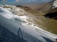 5. My shadow in the early morning light above the north face
Getting there – “BC”
 6. One of the nasty crevasses in the beginning of the route.
There’s one valley leading straight up to the face of the west summit. There may be routes to the left of the actual face leading up to the north ridge, but they seemed to be full of objective danger in terms of falling ice blocks and rocks.
 7. View of the corniced ridge from below.
Anyway, walk up into a valley in between two rocky ridges and after about 200-250m of altitude gain the ground flattens out. Here’s the last place where you can pitch a tent in shelter from the hard winds higher up on the peak and it’s the last place where you don’t have to dig a platform. Don’t expect to find any water here, probably not even snow if you’re not going here in the winter as we did.
It’s better to camp on the left hand side of the valley as there’s more shelter from the nasty winds coming down from the peak. Also there’s more sun here.
The Route
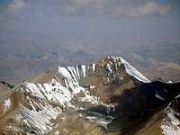
 The whole route visible. It's the long ridge starting from right to left to the summit.
 8. Looking down on the ridge. Noijin Kangsang in the background.
Scramble up to the ridge. The easiest way is probably to shoot for the little saddle at the end of the valley. It’s steep and on very tedious rock and gravel. When you have reached the saddle you have excellent views of the NE glacier and the normal route on the peak. It’s possible to pitch a tent on the saddle and there’s some shelter, but expect to camp in a place which remind you of a wind tunnel.
Head up the ridge along the path of least complication. There are some spots you have to deal with some easy scrambling, but nothing serious in terms of actual climbing. The rock is very loose here though, so be careful.
 9. The west pillar of the peak seen from 6550m
At about 5800m the rock finishes abruptly and you’re on the glacier. The ridge is quite wide to start with, but soon it changes appearance. On the right it drops down towards the valley of the north face and the actual ridge continues steep up to a rock bastion. It makes no sense to climb up to it and you better chose going below it and get onto the ridge further on. It’s a section of traversing on up to about 45 degrees here. There are long horizontal crevasses here. When you have reached the ridge again, it’s very straight forward for some time but be careful as the ridge is split by huge crevasses in some places. The largest one can’t be jumped, but it’s easy to climb around it on the left hand side.
The ridge gets steeper and steeper. Try to stay on the left hand side as the right is very steep in some places and also messy with seracs and crevasses below the ridge. The route condition heavily depends on what the wind has been like and how much snow the ridge has gotten lately. When I was there it was covered in very soft large cornices which I would have fallen straight through if I had tried to use them. At some places you have to make a choice about how steep you want to traverse below the ridge and how much risk you want to take being on the actual cornices. When the conditions are perfect, my guess is you can walk on top of the ridge almost all the way. At about 6450m the steep part is over and you have a long ridge walk to the part where the west slopes gets steeper and drops all the way down to the valley west of kaluxung.
This can probably also be very straight forward if:
1. The wind is not too strong.
2. The ice on the west side is negotiable.
3. The ridge isn’t too corniced.
All the three above were very much to my disadvantage. The ice was rotten on top and black and rock hard underneath the rotten surface. The wind was up to 26-28m/s and the ridge was very corniced. I made it up to the huge hanging, rounded cornice just below 6600m, where I found it smart to turn back. From what I could see, I just had had to climb up onto a little high point just above the cornice, descend into a wide valley on the ridge and then climb the last gently sloped part up to the summit. The distance from where I turned back is about 850m and the altidude gain about a hundred.
 The cornice in medium and hard winds
Gear
Equip yourself with extremely warm clothing, tent and sleeping bag even if you attempt the peak in summer. It may be warm in Lhasa, which is actually the tropical lowlands of Tibet, and in the valleys around Kaluxung, but the winds on the peak can be murderous and the area is infamous for very quick weather changes. The closeness to two big lakes and the fact that both Kaluxung and Noijin Kangsang are quite lonely on the Tibetan plateau are causes for that.For the climbing itself you need crampons, at least one axe and if you want to play it safe all gear needed for crevasse rescues and/or for belaying on moderately steep snow and ice.
Video
A short film sequence shot from the flat part of the ridge at about 6450m. As you can see the wind is coming from two directions and that made the climb a bit unpredictable at all times. The really strong gusts came from the left and the more constant, but weaker from the direction of the ridge.

Bruno - Mar 19, 2009 1:54 pm - Voted 10/10
Not twice... but probably three timesKaluxung has been climbed twice. [...] First by a Japanese team in 2005 [...] The second ascent was made by Bruno Tibet in 2007 via the same route[...]
Hi Janne! I found the report from the Germans who made the second ascent in 2005, but eroneously called the peak Jetung Chusang. This means that the peak has been summitted at least three times.
I added a new chapter in the Kaluxung main page, and partly translated the expedition report from the Germans. It gives more information on both Japanese and german ascents.
Corax - Mar 19, 2009 10:38 pm - Hasn't voted
Re: Not twice... but probably three timesThanks. I had never heard about the German ascent. I'll add the info.