|
|
Route |
|---|---|
|
|
36.30800°N / 118.287°W |
|
|
Hike |
|
|
Half a day |
|
|
Class 1 walk-up |
|
|
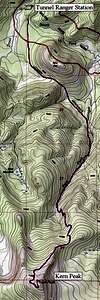
Approach
See "Getting There" section of the Kern Peak main page.
Route Description
For a maintained trail, the Kern Peak summit trail can be frustratingly vague because of the shifting sand. Even the topographic map describes the trail as “Location Approximate.”
From Tunnel Guard Station head south, walking around the west side of Red Hill. Just after reaching the saddle south of Red Hill at 9,050 feet, the trail forks. Look carefully for the fork because it is easy to miss and end up at Ramshaw Meadows. Take the trail heading south (right) eventually reaching Kern Peak Stringer. Continue up Kern Peak Stringer and climb up a shoulder of Kern Peak. Along the way there are some good views of Kern Peak. The trail follows the shoulder then crosses the peak’s north slope and climbs to the summit. There are ruins of an old fire lookout station on the summit.
 |
Essential Gear
None required.
Miscellaneous Info
If you have information about this route that doesn't pertain to any of the other sections, please add it here.