
|
|
Route |
|---|---|
|
|
46.56329°N / 7.99230°E |
|
|
Mountaineering, Mixed |
|
|
Spring, Summer, Fall, Winter |
|
|
A long day |
|
|
TD IV 60° |
|
|
IV |
|
|
Overview
 Mönch
MönchThe Lauper Route follows the striking north face rib, which divides the north face diagonally into two parts. This route is deemed to be an exceptionally nice, though demanding, mixed climb. Assume 10-12 hours from Guggi Hut to the summit. Little objective risk. The commitment depends strongly on snow/ice conditions. This route can be climbed all over the year, though spring/fall promise best conditions. With less névé this route becomes harder at several sections.
 Overview
The first ascent was made on July 23rd 1921 by Hans Lauper and Max Liniger, likewise being the first ascent of the Mönch north face. Lauper also made several other first ascents in the Bernese Alps such as the northeast face of Eiger (1932, ED-) and the Jungfrau northwest rib (1926, TD).
Approach
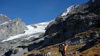 Approach
The original route was made from the station "Eigergletscher" (2320 m) of the Jungfraubahn railway. Crossing the strongly crevassed Eigergletscher this approach gained the north face rib at the very bottom.
Today the approach from the Guggi Hut is preferred. For information on the approach to the hut see the Guggi Hut page. From "Kleine Scheidegg" the approach will take 3½ hours, from "Station Eigergletscher" 3 hours.
Route Description
 Vertical crack
From the Guggi Hut (2791 m) cross the northwest flank nearly horizontal to the left side (N) and follow it easily to the Mönchsplateau (3112 m).
Across snow and rock over the slightly distinctive ridge to the next rise of the ridge (ca 3180 m) from where you can see the glacier basin directly below to the east. Descend the steep snow/rock slope near or along the small rib (NNW), then turn to the right side (E) to reach a snow ramp (45°) leading down to the glacier basin. Pass the bergschrund; easier on the far left (NW, below the rock bar) or right (SE), then traverse the flat glacier basin (ca 3100 m) to the east to reach a snow cone beneath the shoulder of the center ice field dividing the Lauper Rib. Climb the southwest face (II, 80 m) through weathered, fragile rock to gain the ice field.
Follow this constantly steepening ice field (45-50°) on its left side. Exit the ice field at the top, changing to the third (top) snow ledge on the right side which is crossing the great limestone barrier nearly horizontal.
Continue this ledge to the west. There are small possibilities protecting this traverse, you can use ice screws if there's enough ice or otherwise nuts/pitons. At the west end of this ledge climb a vertical, often iced crack (IV, several pitons), above it some easier mixed terrain to a belay behind the big split off block. What follows now is the famous "Schulterstand" of the Lauper Route. Climb up the block and on the shoulders of your partner to reach the roof of the limestone barrier (V or IV/A1). There are some pitons and cords to assist you. You also can climb the roof artificially with some slings, strenuous though. Another belay is directly above the roof (3500 m).
From here on climb straight upwards over stratified plates (40-45°). Easy while there's enough névé, otherwise extremely delicate when there's only little snow or even water ice on these plates (late summer). Barely chances to lay protection, pitons can be useful again. Keep right when reaching the next barrier with the passage from limestone to gneiss (3650 m).
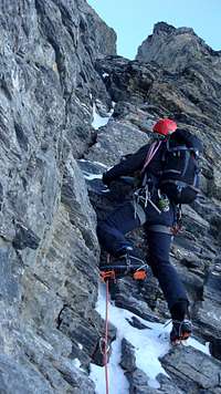
 Exit couloir
Here you've got two possibilities. Either through rock, climbing directly the very pleasant gneiss of the Lauper Rib (III), or use the ice couloir (50°) to the right ascending parallel to the rib. The couloir is steepening to its finish (60°), possibly with a fine ice trace on its right side.
The Lauper Rib is joining the NE ridge at approximately 4030 m. Follow the moderate snow ridge (40°) to the summit at 4107 m.
The descent along the SE ridge (Normal route) takes vaguely 2 hours.
Essential Gear
Regular glacier gear (rope, crampons, helmet), two ice tools, slings/cords, ice screws, cams, nuts and pitons.Additional Information
 Jungfrau Region - Alpine Touren
Guide book by the Swiss Alpine Club (SAC), formerly known as SAC-Clubführer.
Karl Hausmann. Publication year 2010. ISBN 978-3-85902-308-6.
Price: CHF 54,- / € 40,50 (discount for SAC members)
Link: SAC Online Shop
 Schweizer Landeskarten - Blatt 1229+1249/2520
 Maps scaled 1:25,000 by the Swiss Federal Office of Topography.
The Mönch is situated at the transition of map "1229 Grindelwald" to "1249 Finsteraarhorn", so both maps are needed.
Alternatively map "2520 Jungfrau Region" is a composition covering the mountains around Grindelwald, including the Mönch.
Price: Standard (1229+1249) CHF 14,- / € 9,80 - Composition (2520) CHF 25,- / € 17,80 (discount for SAC members)
Links: SAC Online Shop (1229, 1249, 2520)
External Links
Google Translate can be used to translate websites into English.Jungfraubahnen

Information, prices, timetables of the Jungfraubahnen railways/cableways at Grindelwald. Also several webcams available.
http://www.jungfraubahn.ch
MapPlus
Free online version of the Schweizer Landeskarten maps.
http://www.mapplus.ch/...
bergtour.ch
Information about mountain conditions in the Alps.
http://www.bergtour.ch/...
MeteoSwiss
Weather forecast for Switzerland by the Swiss Federal Office of Meteorology and Climatology.
http://www.meteoswiss.admin.ch
Trip report - Martin Zahn
Detailed report by Martin Zahn who climbed the Lauper Route with Stephan Siegrist on May 20./21. 2001.
http://www.akadia.com/...