Intro/Stats
Little Bear Pk (14037’)
Via SW Ridge
January 14, 2012
8 miles RT, 6000’ gain
Participants: Kevin P, Sarah, Darin, Greg, and Kevin B
Slideshow
The dry winter in Colorado continues, which is bad for skiers and the water supply, but good for mountain climbers! I’ve been hoping that the heavy snows would hold off long enough to squeeze in Little Bear. I’ve done Little Bear twice, once as a mixed climb up the scintillating northwest face in May 2006 and the other time via the Hourglass as an exhilarating snow climb in April 2008. The unpredictability of the Hourglass in winter makes it not very appealing. The southwest ridge is a viable option, but it also brings many challenges with a steep bushwack out of the San Luis valley, followed by a long slog on talus. The approach alone makes this route physically demanding, even though it’s only 8 miles round trip! Although the rockfall danger on this route is minimal, one must be ready to endure over 2500 feet of talus just to get to the fun stuff. It’s a route that I would not recommend, so pick your poison!
The Ridge That Keeps Coming
We all car camped at the “trailhead” Friday night, the directions to which are nicely described on Ryan Schilling’s page on Summitpost. We decided to sort of split the difference with the short amount of daylight we had by doing most of the approach to treeline in the dark so that we could get off the talus before dark. It worked out well even though it turned out to be a much longer day than we anticipated. We set off a bit after 4am from the trailhead at 8800 feet, which is a demoralizing elevation to start at so early in the morning. The key early on is to cross Tobin Creek early enough to not get sucked into steeper terrain higher up. I set a waypoint for around 9100’ and we crossed there. We did have to bust through some thickets, but it wasn’t overly annoying if you’re used to bushwacking. I enjoy the challenge of bushwacking, but long stretches in the dark can be brutal!
The climb out of the Tobin Creek drainage is steep and loose, but we made good time. As is often the case in the Sangres, the ridge is brutally steep. We were making good time, and made it to treeline just in time to catch the sunrise.
Intermittent sections of talus in the trees gave us a preview of the slog to come. As we cleared the trees, it was clear that the weatherman missed the forecast as the banshees were out in full force! Our morale took a huge hit as everyone knew there was no way we would be traversing a narrow ridge in these kind of winds. Greg had a wind meter and clocked a 48 mph gust with temps in the mid-teens. I promptly hit the wall a bit above treeline and was in for a long day as the banshees jumped on my back. Chalk it up to only 3 hours of sleep, a long week at work, and playing ballerina on the talus I guess! It was probably the worst I've felt in the hills in a long time. Momma said there would be days like these! Our only hope was that the winds would die down enough to take a shot at the traverse.
Early light on Ellingwood Point:
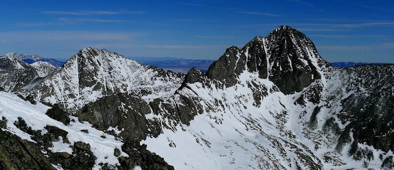
The ridge features a series of bumps along the way to South Little Bear. It’s best to not sidehill very much, although we did so a bit to look for wind shadows on the south and east sides. One of the good things about this climb is you will see some jaw dropping views of Little Bear that few people get to see. The exposure on climbers left is attention getting, but you can avoid it until dropping off the last bump before S. Little Bear.
The big, bad bear makes an appearance:
The winds began to subside as we climbed higher and it seemed like we might have a shot at pulling this off! The excitement amped up as we came to the first little knife edge section.
Some of us went right over the top while others traversed a bit below on the east side. This short section never exceeded 3rd class, but there are some attention getting notches along the way with big air on the west side. The ridge crest was dry while there were some patches of snow to deal with on the east side.
Sarah gets acquainted with the ridge:
Me on an airy ledge enjoying the fine views. Photo by Darin Baker
The short airy section gives way to an easy scramble to the summit of South Little Bear, which is a spectacular perch indeed. It’s only 30 feet lower than the main summit, but it seems higher with the naked eye.
Ellingwood and Blanca from S. Little Bear:
Just getting to South was a considerable amount of effort with the beatdown from the wind, and I was really feeling it. We didn’t stay long as the traverse to the main summit awaited. The final traverse to the main summit does not spend a whole lot of time on the ridge crest as there is a nasty fin below the south summit. We skirted around it on the west side via a series of ledges.
Greg scouting out the ledge traverse:
We crossed a few snowy, exposed sections in which the snow was too shallow to self belay with an axe. Greg did a great job of picking a good line and kicking steps for us. This ledge traverse is right above the Hourglass, a spectacular perch indeed! The route does have a few cairns and would be straightforward in summer, although there is loose rock to be aware of. The crux of the day for us was a 4th class chimney that some of us got a spot on, but Greg found an easier way that we took on the way back.
Looking down the little chimney. Pic quality suffers because I have a smudge on the lens.
The final climb back up to the summit ridge was easy 3rd class, and after almost 8 hours of slogging we made it to the top.
Group hero shot:
We didn’t spend a whole lot of time on the summit because we wanted to be back to treeline before dark. Surely it wouldn’t take us more than 6 hours to get down! I was dreading the descent and it was a brutal one indeed! The traverse back to SLB went a lot quicker this time as we followed our tracks back.
Let the long descent begin:
Looking down the Hourglass:
I decided to take the low route below the knife edge to the next bump, and it seemed to be more tedious than just staying on the ridge. The descent of SLB took a lot of concentration as the talus was larger, but at least it was stable for the most part. I really started dragging despite trying to eat and pump the fluids. I haven’t been this slow in a long time and the gang was nice enough to wait on me. They had to anyway, because I was the only one with a waypoint to the cars! The talus never seemed to end, but we did make it back to treeline well before dark. I think I was going delirious and let out a few token "Cotton Pickets" and "Dab Nabbits" and "Frickin Talus" for the gang when I got back. Those are what you call Nazarene cuss words. We busted out the headlamps with about 1,500 feet to descend in the trees. Let the tripping, tree whacking, and slipping and sliding commence!
We crossed Tobin Creek higher up at around 9,400 feet and now the find the cars game began. Only .52 to go as we followed a road for a bit and regrouped every few minutes. We'll be done in 15 minutes. Yeah, right! Every pow wow knocked off a tenth of a mile at best. Cmon Darin, head for the city lights! Quit drifting right! The dense bushwacking kept us from straightlining it to the car. We finally staggered upon the road at 7:45. If it wasn't for my sorry, slow butt, everyone else would have been down 2 hours sooner! Heck of day on a route that I would not recommend unless you enjoy suffer fests!
Comments
No comments posted yet.