
-
 17150 Hits
-
 82.48% Score
-
 15 Votes
|
|
Canyon |
|---|---|
|
|
Hiking, Canyoneering |
|
|
Spring, Summer, Fall, Winter |
|
|
Overview: Magnificence Personified
Little Santa Anita Canyon juts into the San Gabriel front range just above the foothill town of Sierra Madre. The beautiful Mt. Wilson Trail winds steeply up the west side of the canyon crossing over the head of the canyon before reaching the 5,715 foot summit of Mt. Wilson 7 miles from its start.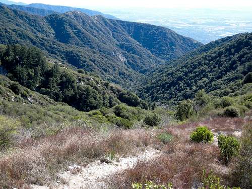 Looking down into Little Santa Anita Canyon from ridge on its west
It is difficult to convey in words the magnificence of this canyon. Just one mile from the trailhead along the trail, the hiker encounters jaw-dropping views of the canyon scouring deep into the mountain. Looking over the trail’s edge to hundreds of feet of precipice below, it is hard to believe that you are not even at 3,000 feet elevation at this point. Most times of the year, you can hear and see some of the many waterfalls that tumble down the canyon bottom.
 Looking down into Little Santa Anita Canyon the Mt. Wilson Trail can be seen center left
Although the Mt. Wilson Trail is seen today in its modern guise, it has an ancient lineage. Hundreds of years ago, and into the 19th century, it was a trail used by the Gabrielino Indians to access the San Gabriel Mountains and even beyond into the desert. At one idyllic glen near the canyon bottom, now known as Orchard Camp, an acorn sprouted about 500 years ago right above the creek bed giving life to what is seen today as a giant oak tree. For the hiker, Orchard Camp is a verdant and shady rest spot on the way to Mt. Wilson and that giant oak never fails to amaze.
 Mt. Wilson (5,715') is a popular destination on the Mt. Wilson Trail
For those wanting to move faster than the average hiker, the town of Sierra Madre sponsors each May the 8.6 mile Mt. Wilson Trail Race. The race starts downtown, picks up the Mt. Wilson Trail at the trailhead, proceeds to Orchard Camp, and then back to the start. A standard feature of the race is Sierra Madre Search and Rescue personnel on hand at the most exposed parts of the trail ready to deal with any mishaps.
Finally, for those wanting to explore the canyon bottom, there is a convenient jumping off point about 1.5 miles into the canyon where a short detour from the main trail leads you down to the creek. This spot is rightfully known as “First Water,” elevation 1,920 feet. Descending the canyon from First Water garners an American Canyoneering Association rating of 3C III. You will need appropriate canyoneering gear and will encounter about 8 rappels. For route and other details see Brennan’s chapter on Little Santa Anita Canyon in his Adventure Hikes and Canyoneering in the San Gabriels.
 GPS track (courtesy Travis Linds) showing, on the right, the length of Little Santa Anita Canyon and how it abuts below Mt. Harvard
 Mt. Harvard (5,440')(C), against which the canyon abuts, seen from the Mt. Wilson Trail
Getting There
The Mt. Wilson Trail trailhead is located within the city limits of Sierra Madre. From the 210 Freeway, exit Baldwin Ave. and go north. When you come to a traffic light where you have to go either right or left, go left to the next light and that is Baldwin Ave. Take a right and continue up Baldwin Ave. through the downtown area of Sierra Madre. Approximately ¾’s of a mile from the downtown plaza, take a right on Mira Monte. Go down about ½ mile and you will come to a small park on your left. Park anywhere in this area long Mira Monte. To get to the trail, walk up the paved road that goes north off of Mira Monte next to the park.Red Tape
No permits are needed for entry into this canyon nor for hiking on the Mt. Wilson Trail. No Adventure Pass is required to park at the Mt. Wilson trailhead because it is not located within the Angeles National Forest.Camping
There are no camping sites or campgrounds in the immediate vicinity of this canyon.Other Information
USGS 7.5 Topo: Mt. WilsonExternal Links
A history of the Mt. Wilson TrailBrennan’s chapter on canyoneering in Little Santa Anita Canyon
ATSadventures - Apr 30, 2008 8:55 pm - Hasn't voted
LSA Canyon Closed!The Sierra Madre fire in late April 2008 has closed this trail indefinitely.
Augie Medina - Apr 30, 2008 9:12 pm - Hasn't voted
Re: LSA Canyon Closed!Yep. I heard that news too. Too bad. It's such a great and popular trail. They'll have to cancel the Mt. Wilson Trail Race as well.
Augie Medina - May 1, 2008 1:47 pm - Hasn't voted
Re: LSA Canyon Closed!Update. According to the Sierra Madre Police Dept., the Mt. Wilson Trail is open as of today. But I personally haven't been up there to confirm.