
|
|
Route |
|---|---|
|
|
46.73700°N / 11.03600°E |
|
|
Mountaineering |
|
|
Spring, Summer, Winter |
|
|
Most of a day |
|
|
F, UIAA grade II |
|
|
Overview
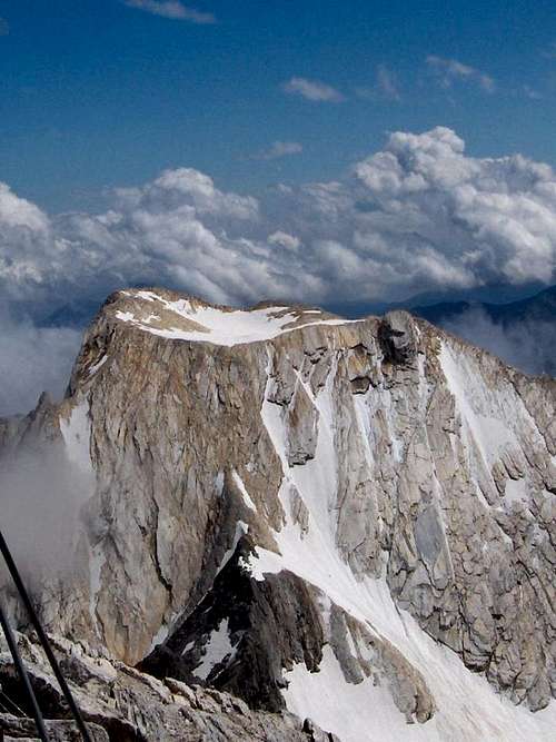
Looking at the Lodner from the Hohe Weiße summit, 50 m higher and one kilometer to the north. As this photo shows, the Lodner N ridge, with the short scramble to the summit plateau, doesn't go all the way up - the upper part is just a rock face. Fortunately, the angle is deceiving and it's not nearly as steep as it looks from here!
The crux of the route is a short scramble, UIAA grade II, on somewhat slippery marble. Just below is some scree, but higher up it's just some loose rocks between the slabs. But even the slabs themselves are sometimes loose.
The Lodnerferner was the route for the first recorded ascent, by V. Hecht and J. Pinggerais in 1872. However, the conditions were totally different then. Ferner is a local word for glacier, and the Lodnerferner was a crevassed one back then and it went all the way up. The marble would not have been exposed yet.
Getting There
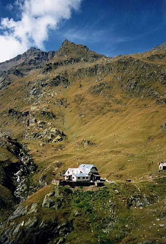
Lodnerhütte in front of Trübwand
South of the Texel Group lies the Vinschgau valley, which can easily be reached by car and public transport (see the main page). The nearest villages are Rabland and Partschins. Located just over 500 and 600m respectively, it's a big ascent all the way up to the Lodnerhütte from there. It's possible to shave a couple of hundred meters off the ascent by driving up part way up the mountain road into the Zieltal. There is parking space at Birkenwald (980m).
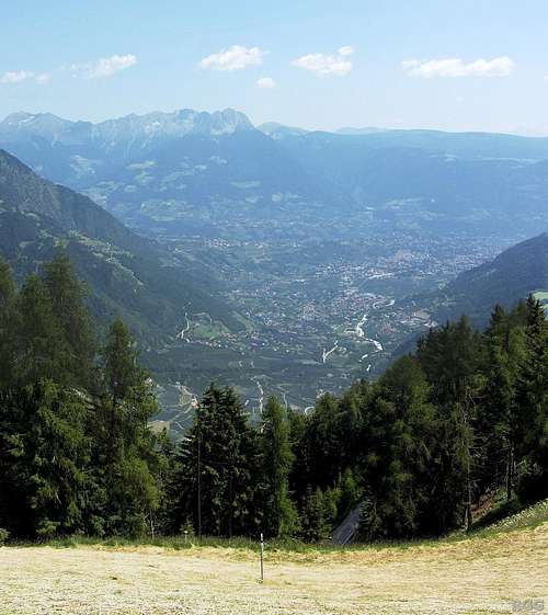
Looking down from the Giggelberg on Meran, 1200m below
An easier alternative is to start in the valley with the Texelbahn cable car to the Giggelberg at 1544m. Follow the well maintained trail nr 24 in northerly direction, leading to the Nassereithhütte (1523m). This is a short section of the Meraner Höhenweg, a popular long distance trail. With ups and downs, winding through the pretty forested slopes, it takes less than an hour to get to the Zieltal, where you'll find the previously mentioned Nassereithhütte. This is a fine place for refreshments.
At this point leave the Meraner Höhenweg and continue in a generally northern direction, heading up the now very scenic Zieltal. This is trail nr 8, and a very clear one. It's still well maintained, but a bit rougher than the one before. From the Texelbahn summit station it takes 3 to 4 hours to hike to the Lodnerhütte, from Birkenwald 4 to 5.
Two other possible starting points for the route are the Stettiner Hütte (2875m) and Eishof Pfossental (2069m). In both cases the approach will be longer (see below), but not prohibitively so.
The Stettiner Hutte lies very close to the Eisjöchl (2895m), the saddle between the Pfossental to the west, and the Pfelderer valley to the northeast. From Pfelders (1628m), one of the last villages in the Pfelderer valley, it's about a 4 hour walk along a different section of the Meraner Höhenweg, up the Pfelderer valley. At the head of the valley you pass the Lazinser Alm (1858m), with food and beverages. The last time I was in the area, I had a break because the weather didn't look very good. Otherwise it's rather early for a break, as it's rather close to Pfelders - you probably haven't even walked an hour yet.
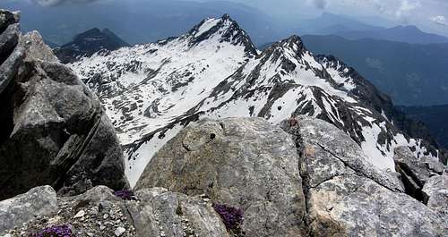
Lodner summit view to Tschigat, in the middle, and the Lazinser Rötelspitze immediately to its right. The Halsljoch saddle between the two isn't visible.
Getting to Eishof Pfossental means an easy hike along a dirt road from the parking lot at Vorderkaser (1670m). Count on 1.5 hours. You can also continue hiking up the Pfossental to the Stettiner Hütte, 2.5 hours from Eishof or 4 hours from Vorderkaser. Or turn south in the Pfossental at around 2500 m or so, go over the Johannesschartl (2854m) and down the Zieltal to the Lodnerhütte.
Interactive Map
The map not only shows all the hiking trails in the area, but also several relatively easy scrambling routes.
Initially, the map is centered on the Lodnerhütte.
At the top, in the center, where all the trails meet, is the Stettiner Hütte.
Eishof Pfossental is in the top left corner.
Route Description
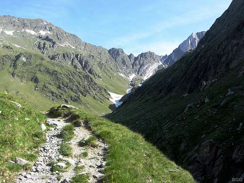
Looking up the Zieltal from the trail, a couple of minutes north of the Lodnerhütte. The Johannesschartl is the distant gap on the right.

Typical trail marker
From the Lodnerhütte
Head north, along trail nr 8 up the Zieltal valley, in the direction of the Johannesschartl and the Stettiner Hütte. The trail heads up on the west side of the valley, well above the stream at the bottom. After a while the valley gets wider and the trail comes closer to the water.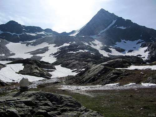
Lodner from high in the Zieltal, around 2600m
Now that the Lodnerferner, the glacier higher up, is reduced to a small ice field, you can take any route up to that shoulder. You'll probably see traces made by others before you, but I advise to look at the terrain and go where it looks easiest. If there is snow and it's not too soft, that may be better than going up the scree.
The exact route to this saddle doesn't matter much now, just find the easiest way to go. Your goal will be to get to the shoulder just right of the saddle.
Don't forget to look around while you climb, for the views get better and better as you get higher.
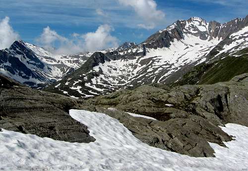
Roteck (3337m), the highest mountain in the Texel Goup, with its prominent east ridge. Seen from the NE, from the slopes below the Lodnerferner.
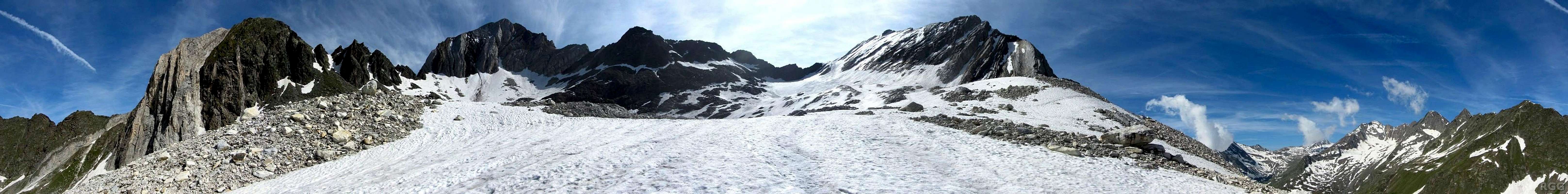
360° panorama from the scree slopes above the Zieltal (the scree isn't too cumbersome, but the snow cover made it even easier).
On the left is Kleine Weiße (3059m), easily recognizable by its two contrasting colors of rock. Scroll to the right, past a jagged ridge, and the Hohe Weiße (3278m) appears, looking rather dark. Keep scrolling, now following the bumpy S ridge of the Hohe Weiße. Eventually that leads to a snow covered shoulder, immediately north of the Lodner. Getting up to that shoulder is your next goal. This panorama shows a wide trail on the snow below it, proof that quite a lot of climbers have recently done the same. Shortly above the shoulder lies the crux of the route, a short climbing section, up to UIAA grade II. The true summit isn't visible, because it's further back on the summit plateau.

This must be the right way
Closer to the saddle, it gets steeper. High up, you'll get on what's left of the Lodnerferner. If there is bare ice, you'll need crampons.
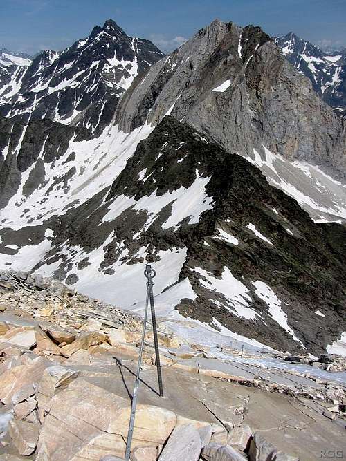
Looking down the crux from the edge of the summit plateau. Nice looking marble, but it's slippery and some of it is loose. These new steel pegs can be used for security, to belay or rappel from.
Without snow, this consists of scree and slippery marble slabs, some of which are loose. Higher up it gets slightly steeper, to about 40°, and there is much less scree. This is the crux of the route, with climbing up to UIAA grade II. Falling is not an option, but the cracks in and around the slabs offer plenty of holds. In addition, big metal rods are drilled into the rocks at regular intervals. They can be used to belay or rappel from.
If there is good, firm snow on this part of the route, it becomes easier, as it provides more traction than the smooth slabs. It also makes it safer, for the snow keeps the loose rocks in place. But it's still steep, and falling is still not a good idea.
From the edge of the summit plateau you can see the summit cross on the other side. It's an easy walk to get there.
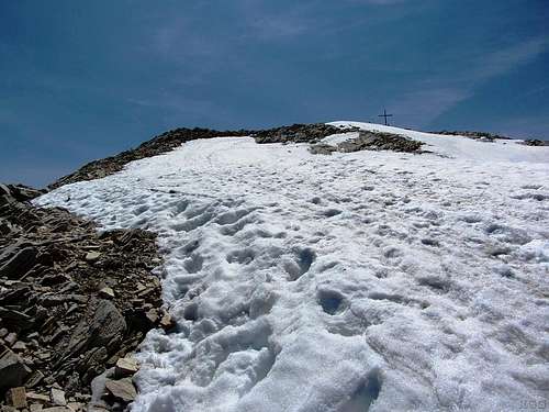
At the edge of the Lodner summit plateau, with the cross in sight
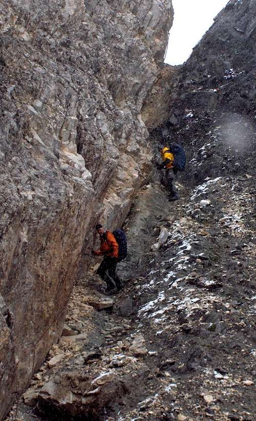
Descending the very steep trail down the Johanneschartl into the Zieltal. This is decent shape!
From the Stettiner Hütte
Head west, over the Eisjöchl, and then turn left towards the Johannesschartl (2854m) at the next trail junction (trail nr 8). After descending on the south side to where it is flatter, turn east towards the Lodnerferner. See above for the rest.This adds 1.5 to 2 hours to the route from the Lodnerhütte if the Johannesschartl is in decent shape. Snow on and around the saddle may cost more time, or worse should you slip.
From Eishof Pfossental
Head east, up the Pfossental. Somewhere above 2500m or so, turn right towards the Johannesschartl (2854m) on trail 25a. You can choose to turn at the sign posted trail junction, or turn earlier make your own way off trail towards the saddle. The advantage is that you can avoid the short downhill section after the trail junction.See above for the rest.
This adds about 3 hours to the normal route from the Lodnerhütte if the Johannesschartl is in decent shape.
When to Go
The route is easier with firm snow on it. Safer too, for snow keeps the loose rocks on the crux in place. Together that makes late spring, early summer the best period. The Lodnerhütte opens early summer, and the warden keeps himself informed about the conditions.If the conditions are right - good snow and low avalanche risk - this route could be descended on skis. However, the Lodner and Stettiner Hütte are closed in winter (but both have a winter room), and with lots of snow it will be harder to get to the base of the Lodnerferner.
Essential Gear
- Crampons and ice axe (in case you need to stop a fall).
- Helmet if there is rockfall danger, especially when there isn't enough snow to cover the scree high up and when you are not alone.
- Rope, harness and a few carabiners if you don't feel comfortable soloing UIAA grade II.