
-
 7504 Hits
-
 78.27% Score
-
 9 Votes
|
|
Mountain/Rock |
|---|---|
|
|
29.17039°N / 13.50054°W |
|
|
1906 ft / 581 m |
|
|
Overview
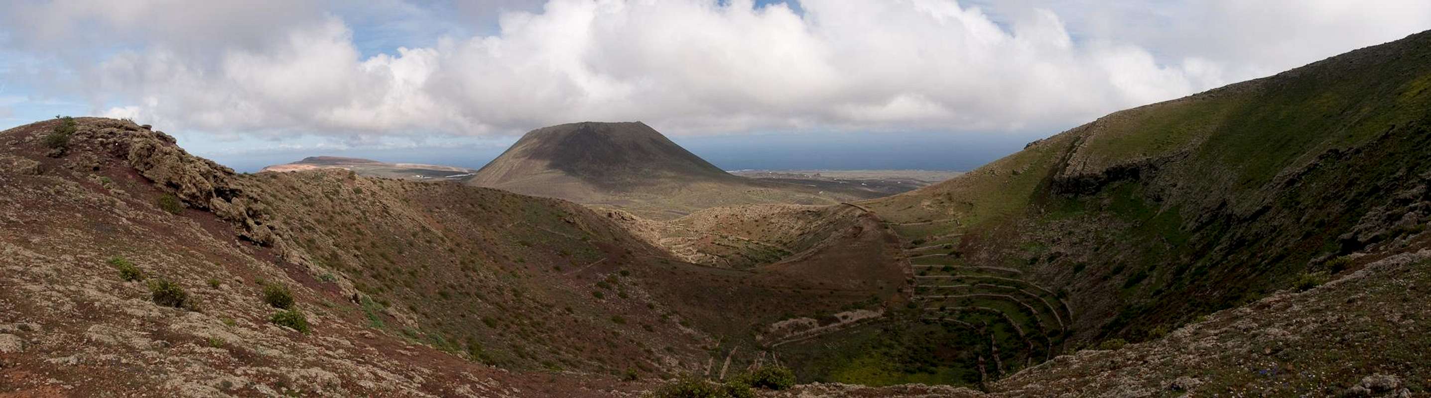
 The wide crater of Los Helechos seen from the east The wide crater of Los Helechos seen from the east |
Los Helechos means "The Ferns" or "The Bracken" and one can easily associate dark forests with dense and humid undergrowth. On the other hand, Los Helechos is an extinct volcano on Lanzarote, an island which you usually associate with the words "barren" or "desert-like". So where is the connection? To be honest - I don't have the glimpse of an idea. Lanzarote doesn't have a single forest and ferns definitely occur elsewhere. Apart from palm trees there are only a few crippled pines in Valle del Malpaso south of Haria and if I say a few I mean less than five. On the other hand, by the end of December 2008, the volcano was embedded in wildflowers, so maybe after all there is something to the name?
 |  |  |
Los Helechos is the second in a line of five volcanic craters, which extends from Maguez in the direction of Orzola at the northernmost tip of Lanzarote. These volcanoes arupted between 3000 and 5000 years ago and covered the north-east of the island with extensive lava flows. Hotspot of the activity was Monte Corona, Los Helechos' neighbour to the north, the dominating mountain in the north of Lanzarote. Los Helechos themselves consist of two craters, which are located south of the village (or hamlet) of Guinate. The higher and larger one is a perfect bowl, open to the north-east). The lower and smaller one is located just to the north-east of the larger one, almost within its mouth.
To the south-west of Los Helechos you find the southernmost of the volcanoes La Quemada de Maguez. Only a barely pronounced saddle separates the two volcanoes, and indeed all climbing routes run across La Quemada's summit through it. There are only less than perfect views from Los Helechos, mainly because of the barrier of Risco de Famara to the west, which blocks views to the Archipelago Chinijo. On the other hand, the view through the crater towards Monte Corona, is quite wonderful.
  |
Speaking of views and routes - there is one route to Los Helechos, which makes up for the obstruction you have on the summit. From Guinate, a steep path leads to the ridge of Risco de Famara, from where a pathless panoramic hike will take you to Fuente de Gayo, where it leaves the ridge, heading for Maguez and Los Helechos. On top of the ridge you have fantastic views of the Archipelago Chinijo and down along the 600m of Risco de Famara. However, the hike, though not difficult, is rather dangerous: the ground on top of the cliff is very soft and can break awy across the edge of the cliff.
Getting There
 Monte Corona and Los Helechos to the right, Risco de Famara left
Though there are ferries from the Spanish mainland to the Canary Islands, they take more than 24h for the trip. Therefore most visitors therefore go by plane. Every travel agency in Europe offers flights, hotel rooms, apartments, rental cars etc. so that reaching the Canaries is rather a matter of money than opportunity. During the summer season flight fares can be reasonable but during the Easter and Christmas holidays you have to be prepared for additional fees of 500€ per person.
Lanzarote has its own airport between the capital Arrecife and one of the main tourist centres, Puerto del Carmen. There are public bus lines but – like on all the islands – they don't run too regularly. If you plan to stay on your own, better take a rental car right at the airport.
Los Helechos can be most easily reached from either the hamlet Guinateon Risco de Famara or from Maguez in its east. There is a wonderful ridge traverse of the Risco from Guinate, which can be used to ascend the volcano.
- From Arrecife take LZ1 through Tahiche to Arrieta.
- Take LZ10 west heading for Haria and Maguez.
- Take LZ205 to Maguez. The best Maguez trailhead is at the northern end of the village
- For Guinate turn onto LZ201 north and after a couple of km turn left (big sign for the Guinate tropical park)
- Don't drive to the park but rather turn off to the left at the second possibility. There's a small parking at the end of the road.
Red Tape
 A sea of wildflowers
Being a part of Risco de Famara, Los Helechos belong to the Parque Natural del Archipelago Chinijo. It was created to protect Islands north of Lanzarote together with the huge Famara Cliff. Mainly seabirds are protected but also all kind of plants you find there. Farming is allowed in the park and close to Maguez you can find small field patches. Also, the north slopes and the inside of the Los Helechos crater formerly were used for farming. Quite obviously this is not the case anymore since the walls, which should protect the fields from the wind are falling into decay.
Accommodation
As for holiday homes, hotels or apartments either consult your nearest travel office, or – search for lodgings on Google. There are several sites on the web, dedicated to rent privately owned houses or apartments. Prices are generally a bit less expensive than for tour operators but you don't have as much security.Weather Conditions
Lanzarote is usually swept by fierce north-western trade winds. Though they deposit their humidity on almost all of the other Canary Islands, Lanzarote is simply too low to form a decent obstacle. Therefore the climate is very arid.
For some time of the year, eastern winds prevail, which almost always carry clouds of Sahara dust with them. Usually this means reduced visibility but in some occasions "Calima" occurs. Fierce storms take up the dust from the Sahara and sweep it across the islands. In these times visibility is nil and sometimes even the planes are grounded.
Maps & Books
Maps
Regular Maps
- Lanzarote
Kompass Map WK241
Kompass Verlag
1:50000
ISBN 3-85491-175-0
Digital Maps
Kompass is the only company known to me which offers GPS digital Maps. In addition for those of you with Garmin GPS receivers there is a map source map set of all Canary islands out there.
- Lanzarote
Kompass GPS4241
Kompass Verlag
ISBN 3-85491-223-4
- Islas Canarias
Map Source custom map
By Manfred Pepper
downloadable zip-file
Books
My recommendation is a guidebook by Rother Verlag, available in German. The book is an excellent hiking guide covering all the interesting areas of the island. Since it comes with small maps for each excursion it might even be used without a map to support them.
- Lanzarote
Rolf Goetz
Rother Verlag
ISBN 3-7633-4302-4