
-
 8321 Hits
-
 86.85% Score
-
 23 Votes
|
|
Mountain/Rock |
|---|---|
|
|
42.9583°S / 171.53329°E |
|
|
Hiking, Mountaineering, Scrambling |
|
|
Spring, Summer, Fall, Winter |
|
|
5997 ft / 1828 m |
|
|
Overview

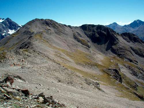
Situated between Avalanche Peak and Mount Bealey in New Zealand's Arthur's Pass National Park is Lyell Peak. Named for the 19th century Scottish geologist and contemporary of Darwin, Charles Lyell, this one sits halfway between the aforementioned mountains on a connecting ridge. The established routes up those peaks are the approaches for Lyell and depending on what type of scrambling you want, you can pick your route to the summit of Lyell. It's Class 3-4 from Bealey and Class 2-3 from Avalanche Peak.
The east side of Lyell is cliffs and waterfalls while the area west of it's main ridge on out to it's SW ridge is steep scree. There is a large cairn atop Lyell but no summit register to sign at this point in time. Keas and New Zealand falcons circle the skies. While Lyell would make a great destination on its own, most really do this as part of the Avalanche-Bealey loop scramble.
Due to its proximity to Arthur's Pass on Highway 73, the main road between Christchurch and the West Coast, when the road is open in winter, this could be done year round, although it would be a mountaineering objective in the winter months.
This area has been a climbing draw for years. The trails are steep but the rewards are many with views into the Shaler Range and higher Southrn Alp peaks to the west, Mt. Rolleston to the north and the Polar Range to the east. Make sure you visit this peak if you are hiking in the Arthur's Pass area.
Getting There

There is but one way to get to this area by car. From the west or east, take Highway 73 to the town of Arthur's Pass. From Christchurch it is 150 kilometers or about 2 hours, from Greymouth it is 100 kilometers or about an hour and a half. You'll need to check in at the Department of Conservation in the middle of town on the west side of the road.
If you are taking Scott's Track up to Avalanche Peak first and then traversing south to Lyell and/or Bealey, that trailhead is found just north of town right next to a small waterfall and directly across the valley from the large Devils Punchbowl Falls. There is a green sign that marks this track.
If you are taking the Bealey Track up, this trailhead is found on the south end of town. Turn west of Mt. Bealey Road (near the sign for the police station) and go to road's end at the trailhead.
An alternative to auto travel is to take the TranzAlpine Train from Christchurch.
Red Tape
No real red tape as far as fees go (none). It is strongly suggested you check in with the Department of Conservation/Arthur's Pass Visitor Centre. There is a sign-in sheet and you can check on area and trail conditions, weather, get maps etc.Arthur's Pass Visitor Centre
PO Box 8
Arthur's Pass
phone +64 3 318 9211
fax +64 3 318 9210
Camping
The Department of Conservation operates a system of 30 huts throughout the park. Contact them through their website or email them at arthurspassvc@doc.govt.nz for more information. The nearest shelter is the Crow Hut that lies in the valley west of Avalanche Peak.For accomodation in Arthur's Pass, you can check this website or I would recommend Arthur's Pass Alpine Motel for a nice clean, quiet place to spend the night before a climb. Say hello to the Jack Russel terrier the owners have there.
Mountain Conditions
Arthur's Pass Weather
Backcountry Avalanche Info
Track Conditions