Route description
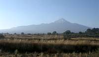
PHOTO 1: The first shot is Malinche from the bus window. This is basically the first view you will get of the mountain. At this point, you are still around an hour from the visitors center.
PHOTO 2: This second photo is a nice interpretive sign about 100 feet up the trailhead (which starts out as a road). Finding the start is easy--you just begin the hike from the snack shop and breakfast area in the visitor's center. The visitor's center is sweet, they have cabins to rent WITH HOT WATER and bunk beds. It is also a great spot to acclimatize as the cabins are high up in the mountains. They are a bit pricey though (maybe $65 a night) and I would recommend reserving one a day in advance. When we were there the Mexican Boxing team was had the place about 90% booked. They use the area to train due to the altitude. The phone number of the camp should be in the Lonely Planet. If not, see the link at the bottom of this write-up.
![Malinche shot at treeline]()
PHOTO 3: The third photo is your first view of the summit of Malinche. You hike through forest up some eroding terrain to get to there. It took me about an hour or an hour and 10 minutes to get to this point (moving at a good clip). Basically, you come out of the woods and BAM, there she is. It really is a beautiful sight. There are 2 summits, the one on the left is what you are heading for (take note of the ridgeline). At first glimpse, the one on the right looks higher, but don't be fooled. I also heard there is a ton of loose rock on the one on the right. I was planning on going up it after the main summit, but some bad weather came in.
PHOTO 4: This shot was taken after leaving the tree-line on the ay to the ridgeline. Once you get up a bit higher than this photo, it was easier to get out of the eroded soil and make fresh tracks. Easy hiking, just heading up eroded soil towards the ridgeline visible in photo 3.
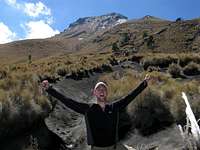
PHOTO 5: This shot is up on the ridgeline. The windward side of the ridge was covered in these frozen plants. I put on my jacket and zipped up my pants just before I crested it (smart move). From here it is an easy, windy hike to the summit. You will be feeling the altitude by now, so take it easy. This is your first good shot to see if it looks like any storms are approaching.
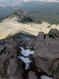
PHOTO 6: This is further up the ridgline looking back (down) at the terrain you just came up. You can see the entire frost/snowpacked ridgeline from here. You can also see the entire 'route' and how much higher we are than the other summit (that I mentioned was loose and rocky). Also take note of where the trail comes out of the treeline.
PHOTO 7: I hung out up top for a good hour, getting used to the sweet yet lucid air. When another group of climbers caught up, I started down and took these shots of them heading up to the summit. It gives you a good idea of the scale and ease of the final hike to the summit. Mostly 2nd-3rd class with maybe 3 4th class moves.
Malinche is basically super easy to set-up, easy to climb, and great for acclimatization. The other peaks in the area require a lot more coordination, both in terms of route-finding and access to the trailhead.
Links and extra info
Great site on Malinche cabin info
Here is some info for the guide I used on Ixta and Orizaba:
"Cristobal Corona"
, was my great, yet very old (65) guide. We developed a great relationship during my time in Mexico. He also has extra beds in his house in D.F. that he rents out. Although it is pricey, he will pick people up at the airport, and drive them to trailheads. He can even act as a guide (although he is getting very old to guide). The important thing is that he has climbed all these peaks as much as anyone else, and is very dependable. Oh yeah, his wife is also a wicked good cook.
Cristobal's address
Mixcalco 321
Colonia Vivente Villada
Ciudad nezahualcoyotl
Estado de Mexico
Tel. 5765-6820
An English speaking member of his staff is named named Martin--a great guy. He invited me to his daughter's quincienera. It was a great time and involved them making me drink way too much tequila the night before heading out for the Ixta climb.
Martin Paulin
Climbing staff
paulinmeztli@gmail.com
5735-3997, ext. 105.
Comments
No comments posted yet.