Overview
This was a mountain I had been wanting to get out of the way for sometime. I see it every day when I leave my home in North Las Vegas straight south of me in the distance. I knew there were 2 ways to hike this mountain.
Jim decided to hike it from Pine Spring. This route is supposedly easier to get to with less off roading required than hiking it from Railroad Spring. However, this route is about 8.5-10 miles. Later I did more research after this hike and found out hiking from Railroad Spring is only about 3 miles round trip. This route had many ups and downs as well. The total elevation gain was almost 3,000 feet making it a fairly long day.
The drive there was gorgeous. Driving down HWY 95 from Las Vegas the Highland Range was spectacular with the morning sun shining on them. The off roads to Pine Spring were in good condition. Towards the end a high clearance vehicle is defiantly needed, but we had no major problems.
The Hike
We followed
this route from Pine Spring. It started off hiking North over a few ridges. We then entered a huge and wide sandy wash which we took heading NW. Eventually this wash narrowed. There were many signs of bulls in the area.
![GPS Trace for McCullough Mountain from Pine Spring]() GPS Trace
GPS Trace
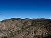
After just over a mile we took a side wash on the right side of the main wash and headed up onto the ridge. We headed north along the ridge and eventually contoured heading East along this ridge. At this point we were straight south of McCullough Mountain, but unfortunately there is not a ridge heading straight there from here. We continued hiking east a little ways until we took a ridge to the north. There were many ups and downs at this point.
Once we started heading north along the next ridge heading towards the summit there were more ups and downs as we passed some rocky outcrops. Jim saw a bull as well. It heard us coming and ran away in the trees. At least it didn't charge towards us.
Further up this ridge heading north there was a point where we could go down the ridge and take a wash that would lead us to the summit. We chose to stay on the ridge heading North and eventually contoured on the ridge heading West towards the summit.
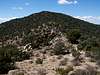
The vegetation was rough in spots. I had to be careful to not get bush wacked. I made the right decision wearing long pants instead of shorts on this hike.
| Waypoint | Latitude | Longitude | Elevation (feet) | Distance from Trailhead (miles) |
WPT 1 | 35° 34’ 23.7 N | 115° 9’ 20.7 W | 5,376’ | 0.00 |
| WPT 2 | 35° 34’ 25.3 N | 115° 9’ 20.7 W | 5,540' | 0.12 |
WPT 3 | 35° 34’ 26.4 N | 115° 9’ 29.8 W | 5,482' | 0.14 |
| WPT 4 | 35° 34’ 31.7 N | 115° 9’ 35.4 W | 5,500' | 0.33 |
| WPT 5 |
35° 34’ 34.6 N | 115° 9’ 36 W | 5'538' | 0.39 |
| WPT 6 | 35° 34’ 46.7 N | 115° 9’ 55.8 W | 5,674’ | 0.85 |
WPT 7 | 35°34'46.1"N | 115°10'05.0"W | 5,764’ | 1.06 |
| WPT 8 | 35° 34’ 48.1 N | 115° 10’ 7.6 W | 5,830' | 1.11 |
WPT 9 | 35° 34’ 53.5 N | 115° 10’ 5.7 W | 6,077' | 1.24 |
| WPT 10 | 35° 34’ 57.5 N | 115° 10’ 13.7 W | 6,218’ | 1.39 |
WPT 11 | 35° 35’ 0.6 N | 115° 10’ 19.3 W | 6,260' | 1.51 |
| WPT 12 | 35° 35’ 6.0 N | 115° 10’ 28.5 W | 6,399’ | 1.74 |
WPT 13 | 35° 35’ 11.1 N | 115° 10’ 23.0 W | 6,472’ | 1.91 |
| WPT 14 | 35° 35’ 20.3 N | 115° 10’ 10.2 W | 6,291’ | 2.22 |
| WPT 15 | 35° 35’ 25.3 N | 115° 10’ 0.3 W | 6,414’ | 2.44 |
| WPT 16 | 35° 35’ 26.1 N | 115° 9’ 56.3 W | 6,393’ |
2.52 |
| WPT 17 | 35° 35’ 31.4 N | 115° 9’ 56.2 W | 6,250’ | 2.63 |
| WPT 18 | 35° 35’ 42.4 N | 115° 9’ 55.2 W |
6,314’ | 2.88 |
| WPT 19 | 35° 36’ 16.7 N | 115° 10’ 16.6 W | 6,870’ | 4.03 |
| WPT 20 | 35° 36’ 15.1 N | 115° 10’ 37 W |
6’775' | 4.41 |
| WPT 21 | Summit | Summit | 7,026’ | 4.63 |
| Waypoint | Latitude | Longitude | Elevation (feet) | Distance from Summimt (miles) | Total Trip Distance (miles) |
| WPT 22 | 35° 36’10.5 N | 115° 10' 38.3 W | 6,723’ | 0.20 | 4.83 |
| WPT 23 | 35° 36’ 36.3 N | 115° 9’58.3 W | 6,113' | 1.37 | 6.07 |
| WPT 24 | 35° 36’ 33.6 N | 115° 9’56.4 W | 6,230’ | 1.44 | 6.14 |
There was a class 3 section in the wash. 0.86 miles from summit. (5.49 miles total), between WPTs 22 and 23.
To return from here, we followed WPTS 17 and down and return back.
The Summit
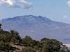
After a few hours and about 4.63 miles we finally reached the summit. Great panaromas were to be enjoyed from here. To the North we could see the Las Vegas Metro area and the strip. The Spring Mountains were capped with snow. Many desert peaks were seen in all directions as well. To the west we had nice views of
Devil Peak. Far off to the Southeast
Spirit Mountain dominated the view.
Return Hike
Our return trip we decided to try out the wash that was off the southeast ridge from the summit. This was a nice route. After a ways we gained the ridge and met back up along our route we ascended. This was a good choice as it cut off over a half mile off our return trip.
By the time we returned we were ready to head back to town and get a good meal. We went to Chevys in Henderson, NV. The shrimp and crab enchiladas were excellent. Jim and I had lots of refills of Ice Tea. We told our waiter, Omar, that we just finished hiking about 10 miles and that we were very thirsty. He always kept our glasses full of tea, we never had to ask for refills. Omar thought we were crazy hiking so much. If you ever visit Chevys in Henderson you definitely will not go wrong with him as your waiter!
Comments
No comments posted yet.