
Comments
No comments posted yet.
After researching some on the Snowy Range and the Medicine Bow Mountains of southern Wyoming, I vetted the Medicine Bow Peak SummitPost page. Only a few hours from my new home in The Cowboy State, the peak gave me no reason to resist going, particularly given how interesting the area looked in the pictures.
It was on Saturday September 16 that I decided to drive the distance and make an attempt. I was under the impression from SummitPost’s description of the peak that it was not a difficult one to ascend. The local forecast said that it would be windy that day, and that the night would be almost windless. The temperature looked reasonable, for in Saratoga it was to be in the 30's that evening. This was weeks before coming across the Mountain-Forecast website that gives forecasts, wind speeds, precipitation, etc. at the elevation and GPS coordinates of popular peaks around the world.
The gear to come along would be nothing too special besides a couple items— I decided to bring the ice axe I’d just purchased, and the new solo tent that I’d tested the night before on my back porch.
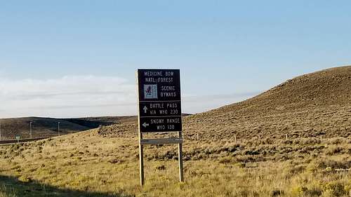
The Marie Lake West trailhead was very accessible at a parking lot just off WYO130, the scenic byway of the Snowy Range where the Medicine Bow Mountains resided. And snowy it looked to be! Even in the warmth of the day, the trees and mountains were frosted with snow.
Preparing for the hike in clear, cool and breezy conditions, I noticed that everyone besides one couple was at the end of their own hikes. A few people had made the loop of approximately seven miles, though they hadn’t gone to the summit. Everyone seemed happy with what they’d done nonetheless. I gathered this by the many smiling faces in the area.
Patches of snow were on the ground near the trailhead. At approximately 3:30 p.m. or so, the couple that had also just arrived went first. Their pace was much quicker than mine, and perhaps because I hadn’t slept the best the night before, I found myself sluggish only a couple hundred vertical feet up from the starting point. Feeling out of breath, I had some water and a snack. Either way, I thought, what’s the hurry? The plan was to camp somewhere up there near the peak anyhow.
The clarity couldn’t have been better. I made sure to stop and take photographs along the way.
Only some spindly cirrus clouds lingered above in the blue. Heading farther upward, and passing more people on their ways down, it wasn’t long before seeing the biggest cairns I’d seen on a trail. This was a perfectly novice hike, I thought to myself, and that didn’t bother me at all since my hiking outings had been occasional at best prior to Wyoming. But I also thought that the cairns could be giant for another reason, and the hint was that snow was already on the ground, below the tree line. Perhaps the area can really see some rough going when a snow storm blows in, I thought.
For a time, though the trail zigged and zagged, its primary direction was northwest alongside some giant hills of rock. The peak was seemingly to the northeast, up and over these hills. Immediately after rising above tree line at perhaps 10,500 feet, the wind kicked in. A very experienced buddy of mine had warned me of the wind in this area. During the two times he’d been to the Medicine Bows, he’d said it was constantly windy.
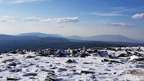
Snow-covered scenery was now in every direction, though the snow wasn’t any more than an inch or two deep, yet. As the trail turned to the northeast, what I figured to be the massive, seemingly always blue-tinted Elk Mountain came into view. That behemoth which rose abruptly from its surrounding horizontals of prairies and ranches was the Snowy Range’s northernmost mountain, unfortunately now forbidden to explore because of private ownership.
Elk Mountain on the right as seen near Medicine Bow peak
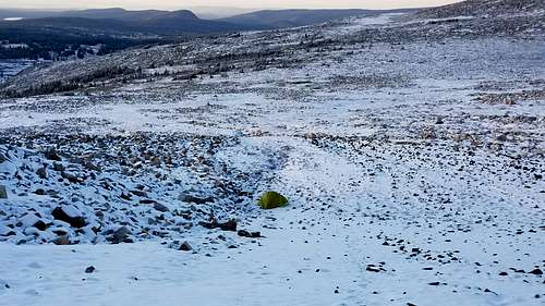
As I continued northeast on a flattening slope, the snow became ankle deep, and sometimes deeper. At times, even, I could see that other hikers hadn’t been able to avoid post holing. It was of course a privilege to be walking in their footsteps in this way. The trail now crossed a field of snow that flattened out and then began a very gradual decline. Coming even farther around the bend, I could see the couple perhaps three-quarters of a mile away. Though they hadn’t started very far ahead of me on the trail, they’d progressed more quickly, and so they were already making their way up to the peak. While they enjoyed their time up there I decided to make camp. Perhaps 50 yards away was a depression between the trail and Lake Marie, which seemingly ran parallel to the peak. The trees looked very distant, and so I sprung the tent up right there.
Solo tent in the gully near Medicine Bow peak
After getting the final stakes in the ground, I entered the tent and my sleeping bag in order to get warm. The ground was at a slight angle downward such that my upper body was elevated above my lower body as I rested. Still, not a big deal, I thought to myself. Then after warming up a bit, I hiked a short ways toward the rocky ridge in order to cook, eat and store my food. As it began getting dark the wind died down, just as the forecast had predicted. The stars began to show in the darkness of the sky. Boiling water for the Mountain House Mexican rice and beans took quite a while, and the eating was uncomfortable in the exposed area. It was also a little precarious balancing my stove system on rocks that had uncertain angles on which I could spill everything. Nonetheless, it worked out in the end. I stashed my food, continuing onward toward the peak to explore some since I wasn’t yet tired.
To date, it would come to be one of the coldest and most uncomfortable nights for me in the backcountry. Though a lean guy, my height did not go well in the solo tent I’d chosen. It was not much better than a bivouac sack with an extended ceiling, it seemed. Anytime I sat up, my head would slide in between the two mesh walls comprising the two sides of the tent. Anytime I was lying flat I felt the end of the tent pressing back on my feet. Anytime I thought I was about to be comfortable, I’d feel like I was sliding down toward the base of the tent. The hill that I’d pitched the tent on seemed to be at a steeper angle than I’d initially anticipated. The outside temperature was perhaps in the twenties, but it seemed just as likely to be in the teens. The old Cabela’s synthetic 15-degree Fahrenheit sleeping bag on a foam RidgeRest pad wasn’t cutting it in this weather. As for water, the remaining three-quarters of a liter that was left was freezing. The nearest water source was down at the lake near the trailhead. Otherwise melting snow was the only option.
Concerning the water furthermore, in the night I realized that my water supply was too low to hardly do anything besides go back down in the morning. I had not melted snow for water before, and I would be surprised if a small pot of a two-cup capacity plus my little propane bottle would suffice. At least it was something to do in such a state of sleeplessness, I thought to myself. So for perhaps an hour I walked around the tent scooping snow from the ground with my gloved hands and dropping it into the sizzling pot. It was baffling to see how much snow it took to make two cups of water. Fortunately I had iodine tablets, so bringing the water to a boil wasn’t necessary. The tablets may have very well been unnecessary as well, but I discovered that my Sawyer water filter had frozen due to the remnants of water in it from when cleaned it last. Perhaps 10 scoopfuls of snow filled the two-cup aluminum pot. It took four or so of these to fill up my one-liter Nalgene all the way. After all that work, the last thing I wanted to do was fill up my other container, a big Gatorade bottle.
By now it was clear that I had completely underestimated the mountain and the frozen terrain. But despite the discomfort, I felt an undoubted sense of coziness up on the mountain as I looked in a few different directions and saw the small clusters of orange light that made up the towns surrounding the area. Laramie was far off to the east. Another patch of lights gleamed to the northwest. Perhaps Saratoga or Rawlins. Each little town seemed like a cozy campfire in the distance. People in each of those places enjoyed the warmth of their homes and communities. Being up on the mountain in the dark like this brought on philosophical ponderings with regards to human observation and experience. Without us, would any other animal on this earth appreciate its beauty as we can? Perhaps this was my own draw to these higher places, I thought—simply to see these wild vistas from the heights with human eyes. It was some of the greatest art work placed in front of the able and willing.
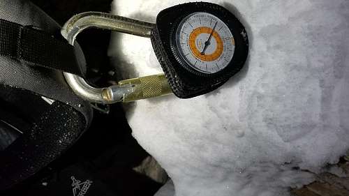
As perhaps 3:00 a.m. sleep had been impossible, even after taking two Benadryl tablets. At least I was protected against any allergens that the breeze might sweep in my direction! Every so often, I’d unzip the vestibule and gaze up at the stars. I experimented with the “Pro” camera feature on my phone, but a good night-sky picture was impossible to capture. Dostoevsky’s The Idiot in the audio version played for perhaps 30 minutes from my phone until I realized I was just wasting battery. At perhaps 4:00 a.m., I began to lethargically stow my belongings into their respective places in preparation for a departure down the route I’d taken. Though I wanted to go to the peak, I couldn’t figure out how far I’d gone already, coming to the conclusion that I’d only gone a mile or so. This estimation of distance was surely obscured by sleep deprivation and, perhaps, altitude. After the fact, I realized I had indeed decided to sleep at an altitude of approximately 11500, i.e., nearly twice as high when at home.
Altimeter reading at camp near Medicine Bow Peak
After finally gathering everything into my backpack, I staggered out of the tiny tent and found myself accompanied by a nearly three-quarter moon that had just risen over the mountain’s edge to my northeast. The night was silent, and the moon moved across the ridge slowly.
The hike back was uneventful, and my attempts to properly photograph the moon were unsuccessful--I couldn't figure out how to get the camera to take in less light while capturing the full figure of the moon simultaneously.
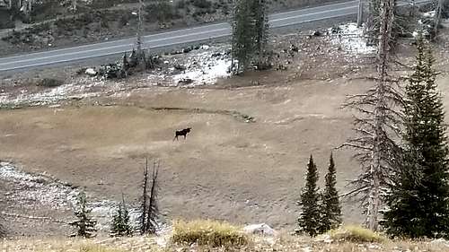
The cairns were so big, finding the way back was effortless, plus I’d see cars down below intermittently, driving on the scenic byway miles in the distance. A big male moose came into view by the parking area as I was descending the final mile or so of trail. It strutted along casually with its antlers riding high. This was in fact the first moose I'd ever seen.
Another attempt at Medicine Bow Peak would hopefully result in reaching the summit, I thought. For now, it was time to get some calories and hot coffee.