
-
 1750 Hits
-
 81.18% Score
-
 13 Votes
|
|
Mountain/Rock |
|---|---|
|
|
47.40038°N / 12.51036°E |
|
|
Hiking |
|
|
Summer, Fall |
|
|
6719 ft / 2048 m |
|
|
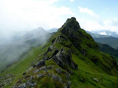
Overview

Mesnerhöhe as seen from Hochwildalm
Mesnerhöhe is a minor summit and a mere bump located on the ridge between Bischof to the north and Sonnspitze to the south. The summit is mainly visited on a traverse Sonnspitze – Bischof and has – in my opinion – no further importance.
Being a not marked route this traverse is not very well known but it is, again in my opinion, a nice traverse with some rock scrambling and a fascinating landscape.
As Bischof and Sonnspitze, Mesnerhöhe belongs to the Glemmtaler Alpen, the east part of Kitzbüheler Alpen and to the Glemmtal north range. One of the most fascinating nature features around this summit is the small lake called Hirschlacke west of the summit.
Getting There

Mesnerhöhe, Pfaffen and Bischof as seen from Sonnspitze ascent
The best trailheads are
You reach the trailhead Aurach Wildpark from Kitzbühel on the road number 161 to Pass Thurn. At Aurach turn on Auracher Straße at the signpost “Wildpark Aurach” and follow this road to Oberaurach and th the trailhead.
Kitzbühel can be reached by car
The nearest railway station to the trailhead Aurach is Kitzbühel. Busses number 4010 or 950X go to Aurach. However there is no bus service to Wildpark Aurach and the trailhead.
You reach the trailhead Hinterglemm / Hochalmbahn on the Glemmer Landesstraße, branching off road number 311 north of Zell am See.
The nearest railway station is Zell am See. Busses number 680 or 965 go to the cableway valley station.
Routes Overview
Routes to and around Mesnerhöhe
Mesnerhöhe is part of the traverse route from Bischof to Sonnspitze or vice versa. The routes to these summits are described on the Sonnspitze or the Bischof page.
From Sonnspitze follow the ridge crest to the northeast first descending about 100 m over steep short rock faces (UIAA grade I) and steep grassy parts until you reach a more level part with a small pond. Ascent on the ridge easily and gradually steeper to the highest point which is the unmarked summit of Mesnerhöhe. Narrow path in some parts.
 Ridge Sonnspitze - Mesnerhöhe |  Ridge Bischof - Mesnerhöhe with Pfaffen rockspire |
From Bischof traverse the meadows below the east-west running summit ridge on its south side until you reach the south ridge dropping down to a rock feature, a bold rock spire called Pfaffen. Descend steeply to a notch in the south ridge in front of this rock feature. Follow a narrow path zigzagging down steeply in the direction of the huge cirque containing the small lake of Hirschlacke.
Below the rocks of Pfaffen turn more south and traverse below the rock spire to another notch on the ridge between Pfaffen and the already visible Mesnerhöhe. Ascend Mesnerhöhe by following the ridge crest over some rock parts (UIAA grade I).
Allow 1 – 1,5 hours for the whole traverse Bischof – Sonnspitze or vice versa.
Through-hikers may inculde this traverse when hiking from Kelchalm / Bochumer Hütte to Wildseeloderhaus.
Red Tape & Accommodation
Mesnerhöhe
No red tape as far as I know.
Up to now (2017) no parking fees at the trailhead.
All kinds of accommodation can be found at
Kitzbühel
Aurach
Jochberg
Saalbach / Hinterglemm
Mountain huts
Hochwildalm
Kelchalm / Bochumer Hütte
Wildseeloderhaus
Gear & Mountain Condition
Mesnerhöhe is a hiking mountain for summer and autumn.In the hiking season you need full hiking gear and good shoes. The route from Bischof or Sonnspitze is not marked, in parts steep and narrow and requires some easy rock scrambling up to UIAA grade I.
When wet or with threatening thunderstorms better stay away!
 A look back from Mesnerhöhe to Sonnspitze |  Mesnerhöhe (left) and Sonnspitze (right) as seen from Bischof ascent |
Current Weather:
Maps
Alpenvereinskarte 1 : 50.000; Kitzbüheler Alpen Ost, Nr. 34/2, Deutscher Alpenverein, 2010; - topo map with trails; the same with ski routes.Österreichische Karte 1 : 50.000 - UTM (ÖK50), map number 3214, Kitzbühel
selinunte01 - Sep 4, 2017 3:30 am - Hasn't voted
Re: 2048sure its meters, somehow it switched back to feet before posting ...