
-
 4148 Hits
-
 76.22% Score
-
 7 Votes
|
|
Route |
|---|---|
|
|
49.18363°N / 20.06537°E |
|
|
Download GPX » View Route on Map |
|
|
Hiking |
|
|
Summer |
|
|
Most of a day |
|
|
Walk up/ Scramble |
|
|
Overview
Mięguszowiecka Przelecz pod Chlopkiem/ Mengusovské sedlo is a quite broad pass situated in High Tatras on the Polish-Slovakian Border at the altitude of 2307 meters which makes it the highest marked-route pass in polish parts of High Tatras. The pass is situated between two promiment peaks- Mięguszowiecki Szczyt Czarny/Východný Mengusovský štít (2410 meters) on the east and Mięguszowiecki Szczyt Pośredni/ Prostredný Mengusovský štít (2393 meters) on the west.
Getting There
The beginning of the route is Palenica Bialczanska. It's a large parking place and the terminus for buses and cars heading to Morskie Oko Lake and the surroundings area. It's located close to Lysa Polana (2 kilometers) which is small village situated on Polish-Slovakian Border.
If you want to get to Palenica Bialczanska you can use your own car or get there by bus.
From Poland :
From Zakopane City there's plenty of buses especially in season viz. June, July, August but you shouldn't get any special problems to caught the bus out of season.
If you want to get to Zakopane City head south from Krakow City. It's about 110 kilometers and it can take about 2 hours but in season
frequent congestion and traffic jams on the section between Nowy Targ City and Zakopane City. If you travel by car you can steer clear of this section by heading east towards Jurgow Border Crossing in Nowy Targ City.
Well developed bus network and railway :

From Slovakia :
The nearest city in the area is Poprad. You can get to Lysa Polana by car or bus and it's about 50 kilometers.

Route Description
The Route begins in Czarny Staw pod Rysami Lake but at first you need to get to Morskie Oko Lake from Palenica Bialczanska Area. It takes about 2 hours and the path is an asphaltic road. There's a huge tourist traffic in summer because it's probably one of the most visited areas in polish part of Tatras. You have no permission to enter there by your own car or by bicycle. In summer season on the route runs horse carriages which can take you to the area of the lake but the use of this means of transport depends on you. Frequent scandals with overworking horses. Also quite high prices.
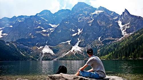
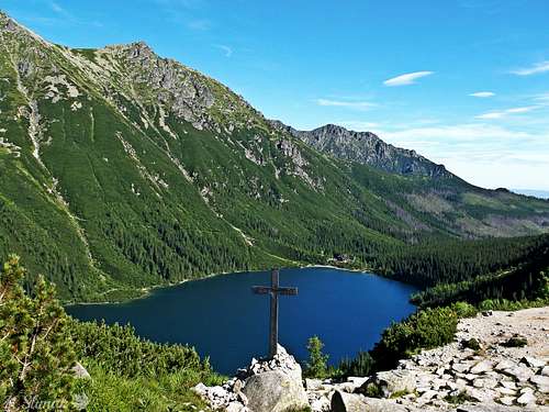
Morskie Oko Lake
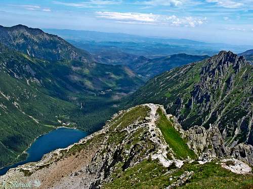
If you get to Morskie Oko Lake then you round the lake from left or right site as you prefer and slowly approach to the lakeside of Czarny Staw pod Rysami. It should take no more than 50 minutes. Beautiful views both from Morskie Oko and Czarny Staw pod Rysami with mighty rock walls all around. The greatest impression exerts overwhelming wall of Kazalnica.
Morskie Oko as seen from Czarny Staw pod Rysami.
Afterwards we choose the green trail and we rise up through the rock debris. The trails approach to the wall of Kazalnica where we start scrambling. Metal staples facilitate overcoming steep walls. Stay cautious especially when the rocks are wet, large steepness all around.
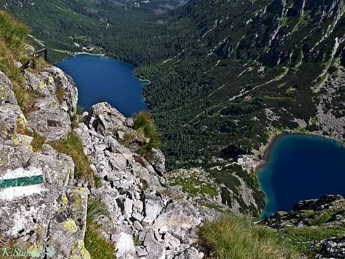 The trail traverses a steep slope
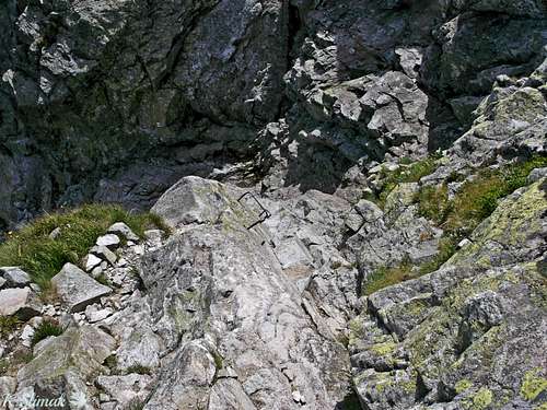
A metal staples make scrambling easier
Stay cautious ! When the rocks are wet it's recommended to hedge your bets.
Slowly we reach the beautiful scenic summit of Kazalnica at the altitude of 2159 meters. A massive wall of Rysy and Niznie Rysy presents mighty from this summit. Morskie Oko and Czarny Staw are under our feet.
Finally you reached the pass. If you want to go down there's no other trail.
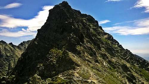
Mieguszowiecka Przelecz
Essential Gear
The trail is intended for tourists accustomed to large steepness. If it's your first time in Tatras, it's recommended to visit other trails before you decide to reach this pass. But don't worry it's not as difficult as many people say it is :) Just make sure that the weather is pretty stable.
In Winter the trail becomes alpine climbing route and a full equipment as well as a lot of experience in climbing are needed.
Despite the fact that the path leading down towards Hincova dolina is well visible, remember that the trail has been closed and going there is antithetical to TANAP rules so the only way to go back is to choose the trail who led you to the pass.
Rescue service in Poland is unpaid so you don't need to buy an insurance like in Slovakia but instead of this there's a little fee which is charged while you enter the National Park. You can buy the tickets in Palenica Bialczanska.
External Links
If you have any corrections to this site please inform me. If this page does not answer your questions you can contact me and I'll be glad to help you and give you more information about the trail and a logistics.
If you have information about this route that doesn't pertain to any of the other sections, please add it here.
If you own some interesting photos from that trail or nearby surroundings area and you would like to share it with others, please add it here.