
|
|
Mountain/Rock |
|---|---|
|
|
Yuma |
|
|
Hiking, Scrambling |
|
|
Winter |
|
|
2775 ft / 846 m |
|
|
Overview
The Mohawk Mountains are located in the Barry M. Goldwater Air Force Range in southwest Arizona. These rugged desert mountains rise sharply above the desert landscape between the cities of Yuma and Gila Bend. Interstate 8 crosses the Mohawk Mountains at Mohawk Pass. The spire-like Point 1975, called Mohawk Peak, is located just north of the pass, and is the most recognizable feature in the Mohawk Mountains. The range highpoint is Mohawk Mountain, and rises to an elevation of 2,775' near Glynns Falls. The Mohawk Mountains see few visitors. The roads into the reservation are rough and primitive, and maps are not entirely accurate. Venturing into this area requires some patience and route-finding skills. Be sure you have a capable vehicle and all the items needed in case you get stuck. In wet weather, the sandy roads become impassable.
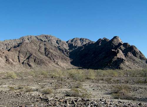 Entrance to hike, with Mohawk Mountain visible to the right as the slightly rounded peak.
Getting There
From Tacna on Interstate 8, drive east to milepost 48. A short distance past this marker, you will see a dirt road on the right leading south. An unlocked gate is across the road here. This gate is marked by spot elevation 343 on the topo map. Go through the gate, and drive south. After about one mile, you will come to the Goldwater Range sign marked by spot elevation 355 on the topo map. Turn left, and drive east about five miles. Follow the roads as shown on the topo map, and always follow the "road more travelled". The Border Patrol run these roads constantly, and it is plainly obvious which are the main roads. You will turn right toward an old gate at this spot elevation about 200' off the road. (See locator map below.) You will probably see a few tire tracks leading to this gate. Drive through the gate and start driving south on the road. This road is not marked on the topo map. The topo map does show a 4WD road (Papago Wells Road) farther east that also leads south, but it is much rougher. Drive south on the road. It was sandy in spots, but much better than the 4WD road marked on the topo map. After about 7.5 miles, this road will turn east and intersect the 4WD road at a road marker designated as G1W. Turn right, and start driving south on the 4WD road, also known as the Mohawk-Papago Well Road. This road has a lot of ruts in it. After about 0.5-mile, you will start to see some tire tracks heading off to the left towards the mountains. Follow the tracks across the gravelly plain until they peter out. You will be about 0.3 mile from the mouth of the ascent canyon.
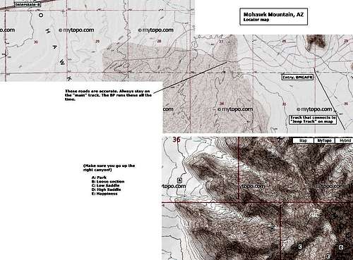 Map showing some important features.
Red Tape
Entry into the Goldwater Range is by permit only. The permit is free. See the external link for contact information. Usually the Border Patrol does not check for your permit. However, the BLM Rangers or military personnel certainly will. If you do not have one, they don't mess around. You will be escorted off the range, cited, and barred from entry. The link below has the information how (and where) to get your permit. You can pick yours up at the MCAS-Yuma on weekdays between 9 and 3, or if you're in Phoenix, go to the BLM offices on 1st Street (just off the Metro Rail Line) and get one there. Barry M. Goldwater Air Force Range Information
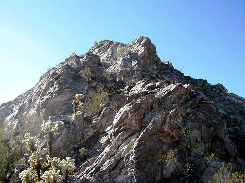 Mohawk Mountain from high saddle
Camping
Primitive camping is allowed on the Goldwater Range. Pack out all trash.
Season
Given the heat this region experiences nearly all year, only climbs in the dead of winter (Dec-Jan-Feb) are possible. It gets warm fast, even in early spring, and stays warm into late fall. Be extremely careful out here as it may be months between visitors to this part of the range.
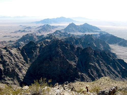 View south from summit.
Route Details
On the map, there are two canyons leading in to the peak; you want the one that starts at the south boundary of Section 36. If you follow the "Getting There" directions, you'll see this canyon. You hike up the gully to a low pass at about 2,250 feet elevation, down the other side a little bit, then up another gully to about 2,570 feet elevation. Then from there, pick your way through the rocky pinnacles to the summit. The initial 700 vertical feet up the first gully is easy: the rocks in the gully are set solid. Brush is moderate. You'll see a large dark rock seemingly intruding into the gully. This is easy to bypass, but immediately afterward, you come to the first crux: a split of the gully. If you go left, it's cliffy. If you go right, it's very steep, loose scree for about 200 feet. We went right. Just deal with the crap, and things will get more solid again. Above this crux to the low saddle, the going is easier again, but the brush starts to thicken, especially cholla. At the first low saddle, peer across and view the next gully that leads to the high saddle. You want to drop left and down across a very loose scree slope (with cholla, of course) about 50 vertical feet to get to the base of this next gully. The climb up this gully is not bad at all. The rocks are solid. As usual, watch the brush. From the high saddle, you probably will veer right and work your way under the rocky pinnacles across loose, brush-choked slopes. Generally stay close to the rock/scree margins. There are some easy third-class open-rock scrambles, but not too bad. You'll come to a small notch directly below the summit. Angle left, and work your way past the palo verde that is growing out a crack in the rock. This short section is very exposed: a fall would be fatal. Most people squeeze between the palo verde and the rock from which it grows. Once past that, there is a lovely ramp that leads right to the top. For the descent, it's best to retrace your route and go slowly. The cholla is extremely thick. The scree is very loose in spots. You may be the only visitors to the summit all year.
Dundeel - Mar 1, 2011 10:54 pm - Hasn't voted
Red TapeThe hours for picking up permits at Yuma MCAS are 9am to 3pm weekdays.
neutscoot - Jan 19, 2021 9:14 am - Hasn't voted
Please do not drive any farther than the Mohawk-Papago Well Road!Driving directions in this post are accurate, but you should not continue down this last stretch: "After about 0.5-mile, you will start to see some tire tracks heading off to the left towards the mountains. Follow the tracks across the gravelly plain until they peter out."
This is not a marked BMGR route and it is against the terms of your permit to drive it. You risk fines, being banned from the range, and ruining access for other hikers. The intersection of this wildcat trail and the M-PW Road (N32° 35.515' W113° 41.585') makes an excellent, legal campsite and adds only 1.2 miles with trivial elevation gain to your climb.
Per BMGR (https://www.mcasyuma.marines.mil/Portals/152/Docs/Range/Range%20Guide-Map.pdf):
"All Roads and trails authorized for travel, on this map, are marked with sign posts at their junctions. If you are traveling on an authorized road, and approach an intersection that does not contain a sign marker, DO NOT alter your course. Some roads are closed to public use. Official intersections are marked by a wooden post with an alpha-numeric designation on it. You are only authorized to travel on the roads, designated on the reverse side of this sheet, as open to the public... Cross-country and off-road travel is strictly prohibited... All roads are considered to be closed unless designated open by an official lettered/numbered 4x4 wooden intersection marker... If or when the Range Management Department determines that, the use of off-road vehicles will cause or is causing considerable adverse effects on the soil, vegetation, wildlife, wildlife habitat or cultural or historic resources of particular areas or trails of the public lands, they will immediately close such areas or trails to the type of off-road vehicles causing such effects, until such time is determined that such adverse effects have been eliminated and that measures have been implemented to prevent future recurrence."
neutscoot - Jan 19, 2021 9:23 am - Hasn't voted
Permit system has changedAs of January 2021, permits can be obtained completely online at https://luke.isportsman.net/. You must register an account and watch a 13-minute video, and then you will be issued a permit valid until the next June 30. You are supposed to print two copies -- one to leave on the dash of your vehicle, and the other to have on your person while out on foot. You must also check-in and check-out online when you plan to visit. You can check-in the day of, or the day before. The permit is valid for both the Marine Corps and Air Force sides of BMGR, as well as Cabeza Prieta NWR. If you enter Cabeza Prieta, you must stop at the refuge boundary and fill out an additional slip that asks for your iSportsman permit number, intended activities, vehicle information, and length of stay.