
-
 3504 Hits
-
 74.01% Score
-
 4 Votes
|
|
Route |
|---|---|
|
|
46.11204°N / 8.83052°E |
|
|
Download GPX » View Route on Map |
|
|
Hiking |
|
|
Half a day |
|
|
Hike |
|
|
Overview
 On the Monte Gambarogno summit ridge On the Monte Gambarogno summit ridge |
The ascent from the hamlet of Monti di Piazzogna to Monte Gambarogno is much more strenuous than the short normal route from Corte di Neggia. Instead of 40 minutes you need about three hours and instead of 400m of elevation gain you have to scale roughly 1000m. Yet, it is also more rewarding as you climb the Gambarogno western slopes, which every now and then offer wonderful views of Lago Maggiore and it surroundings.
The route follows steep mountain trails, which were either created centuries ago to connect the hamlets and villages of the area or to support the military positions near the very top of the mountain. Today, they are mere paths, which run through rather dense forests in their lower sections while they traverse an undergrowth of Alpenroses during the last 300m of ascent. The ssummit ridge between cross summit and real summit is wonderfully panoramic and surprisingly narrow and steep.
Getting There
 Ascona and Locarno seen from the trailhead
The itinerary to Monti di Piazzogna is detailed on the main page of Monte Gambarogno. There is a small parking lot near the centre of the hamlet.
Route Description
 Lago Maggiore seen during the ascent
- Start altitude: 778m
- Summit altitude: 1734m
- Prevailing exposure: W
- Type: Hike
nbsp; - Protection: None
From the parking lotin Monti di Piazzogna return on the road for about 300m. Here a trail crosses the road, which heads up from Piazzogna on the shores of Lago Maggiore towards the saddle Alpe di Neggia. It is older than the road to the saddle and in former times it was used to connect the lakeshore villages with Indemini in the upper Valle Veddasca. Above Monti di Piazzogna the path traverses a steep meadow with lots of alpine flowers before it dives into the forest above.
 |  |  |
In its first section the path gets very close to the mountain road but it forms a circle which soon heads back westwards. Signs lead to Alpe Sambarsciolo (1080m), a small farmstead with a wonderful view upon the northernmost part of Lago Maggiore. The Alpe can be reached in less than 30 minutes from the trailhead.
 |  |  |
In a sharp turn the path now heads up the mountain, leading steeply through the dense forests. It follows a rib at first but then turns westwards, climbing the upper slopes of Valle di Derbor. At around 1300m it leaves the forest but still stays close to its edge. After reaching the upper drainage of Valle di Derbor it heads out onto the alpenroses meadows and finally heads back in a wide turn. Soon, at 1554m, you'll reach an intersection where the Corte di Neggia Route joins.
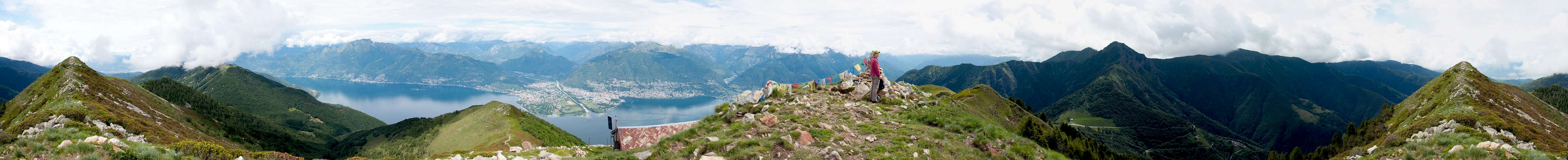  |
Passing the cross summit you head for a saddle (between cross- and real summit) and turn back again to head for the summit cross. Most visitors turn back here, avoiding the real summit. However, a narrow path follows the surprisingly narrow ridge towards the real summit, avoiding the road and the army barracks beneath the top. You'll find Tibetan prayer flags on the summit as well as a wonderful panorama of the Lago Maggiore area.