
|
|
Route |
|---|---|
|
|
44.32806°N / 118.31352°W |
|
|
Half a day |
|
|
Bullrun Rock TH
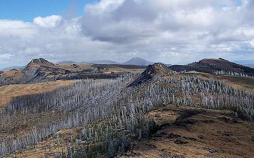
This route will take you from the trailhead beneath Table Rock to Bullrun Rock, Monument Rock, and finally back to the trailhead over the course of 5 miles. This is an easy walk that can be done in half a day with minimal exertion.Begin by parking at the coordinates listed above, this is the trailhead on a switchback in the road to the Table Rock L.O. No fee is required so gear up and begin your hike by walking in a southeasterly direction along an old road. This trail doesnt see a lot of use, so it is faint in areas but Bullrun Rock directly east of the T.H. is the highpoint of the area, and is your destination so march in that direction. Follow the trail 1.5 miles across the Wilderness Meadow area to the base of Bullrun Rock, where you can choose a scramble path up to the summit some 350 feet above.
Once you are satisfied with Bullrun Rock turn your attention to Monument Rock a little less than one mile directly to the south. No trail exists to Monument Rock so choose your path from Bullrun Rock. This is mostly a simple meadow walk with the exception of a few burn areas you will have to navigate. Descend south from Bullrun Rock into the Bullrun Spring area and then directly up the side of Monument Rock as you see fit. Monument Rock is easily tracked as it has its distinguishing summit cairn.
From Monument Rock head northwest past two smaller rockpiles in the Wilderness Meadow back to the trail which you can follow back to the trailhead. From the trailhead you can either walk up to Table Rock less than half a mile with 250 feet of elevation gain to the northwest or 4x4 up to the summit.
The best option may be to drive to the summit of Table Rock to get a view of the Wilderness Meadow before hiking to either Bullrun Rock or Monument Rock. The view afforded from Table Rock will allow you to plan out your hike.
From Trailhead to Bullrun Rock, Monument Rock, and back to TH is nearly 5 miles with 850 feet of elevation gain.
Getting There
From Prairie City turn south onto South Bridge Street and remain on this road which will turn into County Road 62. Follow CR62 up the John Day Valley roughly 8.5 miles to NFD 13 on the east side of the road which travels up Deardorff Creek. Follow paved NFD 13 for twelve miles up and between Baldy Mountain and Lookout Mountain where you will see NFD 1370 on the left, a two lane gravel road travelling east. This road leads all the way to Table Rock lookout approximately 10.5 miles from the turnoff. The roads here are well labeled along the way to Table Rock L.O.