

cgrisha - Nov 17, 2006 6:52 pm - Voted 10/10
nicereally nice place

swm88er - Nov 17, 2006 7:40 pm - Voted 10/10
UnbelievableGreat Shot, this has to be photo of the week.

flow - Nov 17, 2006 9:49 pm - Voted 10/10
really......a great picture!!!

Velebit - Nov 18, 2006 12:22 am - Voted 10/10
Amazing and sadGreat shot of amazing place! So sad to see the reminders of global warming :-(

tuntun - Nov 18, 2006 10:54 am - Voted 10/10
CongratulationFor Photo of the Day..
Great and beautiful photo.
Tun

Casey Bates - Nov 20, 2006 6:27 am - Hasn't voted
Re: CongratulationTun-
Thanks for viewing many of my photos!

MountaingirlBC - Nov 18, 2006 7:51 pm - Voted 10/10
lonely placenow there's a mountain that doesn't get a lot of visitors!
Casey Bates - Nov 21, 2006 7:43 am - Hasn't voted
Re: lonely placeI have not heard much about climbing in that area, have you?
MountaingirlBC - Nov 28, 2006 11:43 pm - Voted 10/10
Re: lonely placeJust that it's extremely remote, the approach is long and arduous and the weather rarely cooperates. I believe there is a BC Mountaineering Club trip in the organizing stages for next year.

23north - Dec 7, 2006 2:54 pm - Voted 10/10
Great Picture!I really like the viewpoint of this picture.
Casey Bates - Dec 8, 2006 6:18 pm - Hasn't voted
Thanks!The photo was taken from a cessna 207, about five minutes into the flight...Unfortunately, I don't know the altitude.

venus - Jan 20, 2007 7:50 pm - Voted 10/10
Very beautifulGreat compo and photo...

MtnGuide - Feb 28, 2007 1:00 pm - Hasn't voted
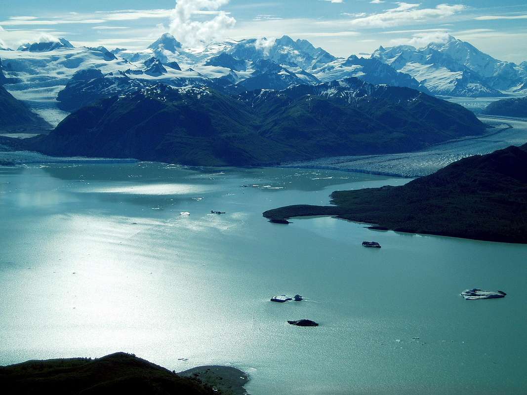
Glacial SeparationI rafted this river in 1976, and these 2 glaciers were so jammed into Alsek Lake that the icebergs were stacked up on top of each other. The river pushed its way under the iceberg jams, creating dangerous sucking eddies, and preventing navigation downstream. We had to race over to the edge of the channel, tow our boats back upstream, and carry them in several trips down the dry channel on the right, along the base of the Brabazon Range, to where the river re-emerged from under the ice jam at the mouth of the Grand Plateau Glacier. That dry channel was probably in the foreground under your plane's belly, just this side of the green mountain on the bottom margin of the photo. We had to haul the boats half a mile, then go back and get our packs and haul them. Amazing.
Casey Bates - Mar 3, 2007 2:55 pm - Hasn't voted
Re: Glacial SeparationMtnGuide that sounds amazing! Thanks for your comment. They now refer to that area as the "Channel fo Death" if conditions are as you describe, but it was pretty mellow when I visited as the winds had not pushed any icebergs in that direction. It looks like that area is changing quite rapidly, as with may other areas in the world, because of the warming climate.
MtnGuide - Mar 19, 2007 8:08 am - Hasn't voted
Re: Glacial SeparationMy theory is that the channel is dry because of tilt-block uplift of the Brabazon Range. Perhaps a fault along the range's base, like along the eastern Sierra. It could even have been lifted suddenly, as by the Good Friday Earthquake of 1964. It is well-documented that that temblor (trembler) triggered avalanches over the next ridges to the South which displaced most of the water in Lituya Bay's cup-shaped basin, into a tidal wave, which lifted several fishing boats and crashed them into the ground. That's at the base of Mt. Fairweather, to the West of that glacier. I'd like to find out if anyone has bothered to climb peaks in the Brabazon Range, other than goat and bear hunters. Easier and more realistic than those monster St. Elias Range peaks. Have you heard of any recorded climbs there?
rgb2 - Sep 9, 2010 1:49 am - Voted 10/10
Great photo!I hope you don't object if I attach this photo to the Coast Mountains area/range page I am working on.
Casey Bates - Sep 18, 2010 10:10 am - Hasn't voted
Re: Great photo!Thanks a ton!


Comments
Post a Comment