
-
 9239 Hits
-
 86.85% Score
-
 23 Votes
|
|
Mountain/Rock |
|---|---|
|
|
45.91397°N / 7.85786°E |
|
|
Valle d'Aosta |
|
|
Mountaineering, Ice Climbing, Scrambling |
|
|
Spring, Summer |
|
|
13671 ft / 4167 m |
|
|
Overview
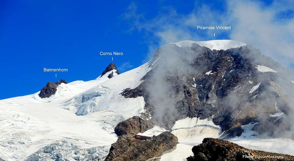
Balmenhorn 4167 m
Balmenhorn 4167 m is a very tiny peak located South-West of Corno Nero-Schwarzhorn on the orographic left side of the Lys Glacier, in the Monte Rosa massif. Its appearance is that one of a small rocky cliff lost in the ice-sea of the Lys Glacier. It is interesting for those people collecting 4000m-peaks, although it has not been accredited in the UIAA official list of the 4000m peaks of the Alps, despite it is higher than for example the Aiguille Verte, the Jungfrau or the Breithorn. In fact Balmenhorn does not meet all the requirements established to be considered a Four-Thousand in all respects, especially as regards the criterion of prominence. The prominence is the difference in height between the peak and the highest hill between the peak itself and another peak of higher height, which must not be less than 30 meters. The definition of the number of the 4000m peaks of the Alps was established by the International Union of Mountaineering Associations (UIAA), which set 82 peaks in 1993 (128 considering also the subsidiary peaks). Balmenhorn was entered on the list of the 46 subsidiary peaks. Check here the complete list of the 82 alpine Fourthousanders and the 46 minor summits: Club4000.
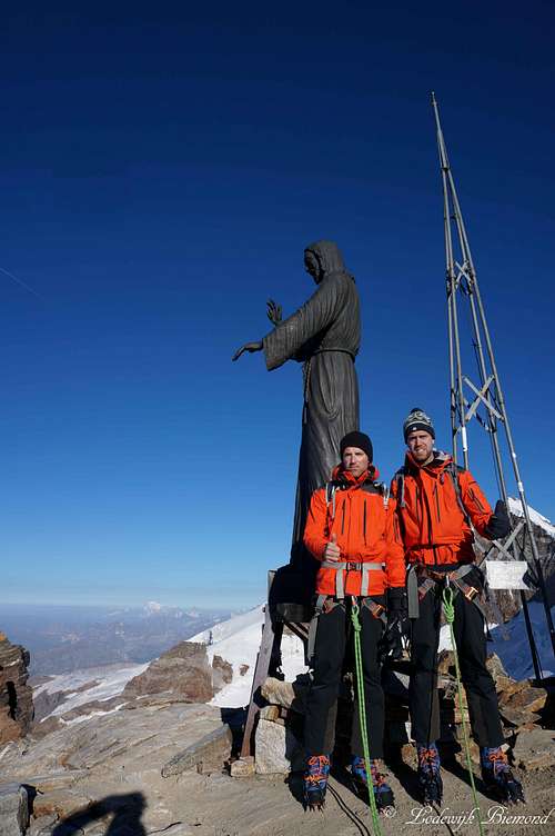
The Balmenhorn has a rock summit and on its highest point there is a Christ statue, named "Cristo delle Vette", which is higher than a normal person. It is made out of bronze and it was created by Alfredo Bai on the 4th of September 1995.
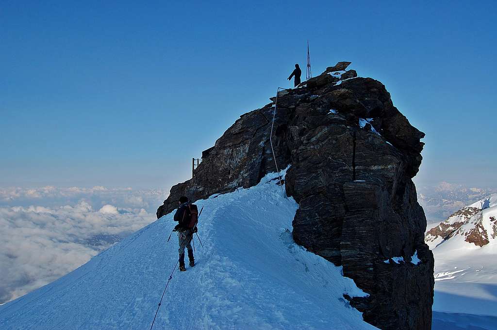
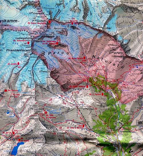
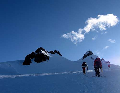
Balmenhorn is reached along the route to the Lys Col running on the Lys glacier across the Rifugio Città di Mantova and Rifugio Giovanni Gnifetti, which is the first part of the extremely popular Punta Gnifetti Normal route. Very rarely it is climbed as a goal in its own right, much more often it is instead climbed as an additional summit during the ascent of the nearby summits (Corno Nero, Punta Parrot, Ludwigshohe and Punta Gnifetti). A few meters below the summit of Balmenhorn it was installed the Bivacco Felice Giordano. Sometimes parties who wish to climb these summits of Monte Rosa massif from the Italian side use the bivouac as a base for the mountaineering and ski mountaineering ascent, but this choice is not recommended, especially in summer, as it is often crowded. It can be exclusively useful as an emergency shelter.
Getting There
Starting from Punta Indren.
Road approach from Italy
Two different approachs roads are possible depending if coming from the Valle di Gressoney (Aosta) or from the Val Sesia (Piemonte).
Access via the Valle di Gressoney (Aosta Valley) - From the A5 Torino – Aosta Highway, exit Pont St. Martin and take the Valle di Gressoney, getting to Gressoney St. Jean, Gressoney La Trinité and Staffal. From Staffal take the cableway to Alpe Gabiet – Passo dei Salati - Indren glacier. The first cableway brings to the middle station of Alpe Gabiet (there is a bar- restaurant called Rifugio Lys) a few minutes from the Gabiet Lake. The second cableway brings to Passo dei Salati, where you can find the new lift to Punta Indren 3250 m. From Indren it starts the walk. From the lift, follow the track crossing the glacier and in about 20 minutes you reach a fork, a low and a high track. Follow the low one until the end of the glacier. Go beyond a rock with fixed ropes (15 meters), than climb up again and shortly the Refuge Mantova hut is reached. It takes about 1 hour from the lift-station to the hut. If you choose the high track where the snow ends it begins a mixed path (rocks and snow) and after a few bends you reach an equipped path. When you reach the topo of this path you see on the left, below, the Refuge Mantova. The time required is about 1 hour. To reach the Capanna Gnifetti from the Mantova Hut you have to cross the Garstelet glacier. This will take up to 30 minutes longer. For information about the cableway from Gressoney to Indren (including prices, timetable) see here: Gressoney cableway.
Access via the Val Sesia (Piemonte) - From the A26 Highway exit to Romagnano Sesia and take the road to Varallo Sesia. Here continue following all the Val Sesia road to Alagna Valsesia. From Alagna Valsesia take the skilifts in three sections: Telecabina Alagna-Pianalunga - Funifor Pianalunga-Passo dei Salati – Funifor Passo dei Salati-Indren. Info here: Alagna Valsesia cableway.
Alternatively by walk (no cable car) it will take 6 h from Alagna
Get to Punta Indren on the marked hiking path n. 5 from Alagna via Dosso (1357m). You go to the Alpe Oltu (1847m, cable car station, 1,5 h) and furth up the Valle d'Olen. You go along the Sasso del Diavolo and reach almost Colle d'Olen, where you turn right to the Vigevano-hut (3 h). You go further along Passo Salati (2936m) to the ridge-crest and traverse Stolemberg. On the side of the Indrenglacier, you reach the station (1 1/4 h, totally 6 h).
Road approach From Switzerland
To Alagna - You reach Alagna by car on the road E62 from Brig via Simplonpass. Turn off at Ornavasso (near Lago Maggiore) and drive to Omegna. Here turn right and drive along the western side of Lago Orta to Borgosésia. In Borgosésia you take the road to the N an reach Alagna via Varallo and Scopello.
To Aosta - You can reach Aosta through the Great St.Bernard Tunnel or the Great St.Bernard Col, then from Aosta reach Pont St. Martin and here take the road running in Val Gressoney to Staffal.
Route

Balmenhorn from Punta Indren
Difficulty: F (Alpine scale)
Difference in level: 907 m from Punta Indren - 556 m from Capanna Gnifetti - 697 m from Rifugio Mantova -
Easy glacierroute, also possible as skitour
Get to the refuges Mantova and Gnifetti from Punta Indren, 3260 m (cable car from Alagna or Gressoney) in 1,5 h via the Rif. Città di Mantova, 1 h to Rif. Città di Mantova. In the lower part, it is a marked path (n. 5). The traverse of the glacier is not marked.
From Punta Indren, traverse the ski-run, slowly going up on the Indrenglacier till you reach the outstanding rock band above which the Mantova-hut is situated (yellow-red signs). You climb up the rock steps (fixed ropes). To reach the Gnifetti Hut from the Mantova Hut you have to cross the glacier going up over the E-side of the glacier to the N and at the end on the rocks to the Gnifetti hut. This will take up to 30 minutes longer.
From the Refuge Gnifetti enter the glacier and follow it at first diagonally to the left (toward North-East) along a steep ramp, then toward North rising on moderate ice-slopes, never too away from the steep slopes of Vincent. In some sections the route presents a few passages between wide crevasses. Continue always along the track, usually present in summer, heading to the Lys Col. Go up the Lys glacier, initially diagonally to the left, on the main track that leads to Punta Gnifetti reaching the snow basin below the Balmenhorn.
Leave the main track on the left, which leads towards Colle del Lys, and turn right along a moderate
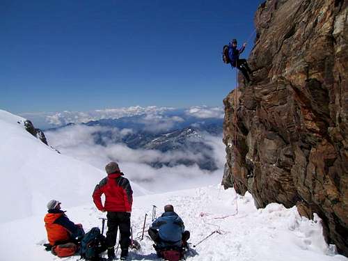
slope in the direction of Colle Vincent 4088 m. Just before reaching it, turn left towards the slope that leads us to the base of the Balmenhorn rocks. After passing this short rocky section equipped with a metal ladder and fixed rope, we reach the statue of Cristo delle Vette (Christ of the Peaks). We are on the summit, a few meters lower there is the Bivacco Felice Giordano.
Descent: reversing the same itinerary.
Red Tape
No particular restriction
When to Climb
Mountaineering: summer
Ski-mountaineering: spring
Huts
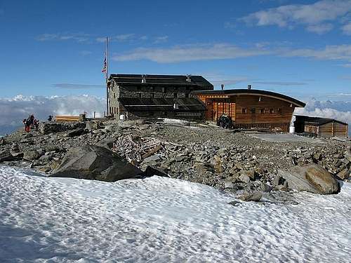
Situation: Garstelet Glacier
Open: from June to September
Size: 85 persons + 15 in the winter-shelter
Owner: Guide di Gressoney
Hut's phone : 0039 0163 78150 / 347 0802910
Email: info@rifugiomantova.it
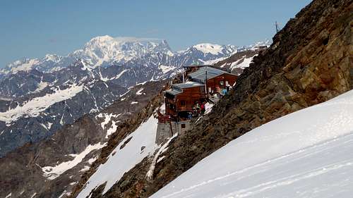
Situation: rockspur between the Lysglacier and the Garsteletglacier
Open: spring from middle March to middle May - summer from middle June to middle September
Size: 176 persons + 4 in the winter-shelter
Hut phone : 0163 78150 / 347 0802910 Email: info@rifugimonterosa.it
Other accomodation
Various possibilities of accomodation, including campings, both in Val Sesia and Val Gressoney
Bibliography
“Monte Rosa” by Gino Buscaini - Guida dei Monti d'Italia C.A.I.-T.C.I.
"4000er Tourenfuhrer" by Richard Goedeke
Meteo forecast
Meteo Valle d'Aosta
Meteo Regione Piemonte
MeteoSwitzerland
External Links
Some opinions about the definition of a mountain
1. akpenkalb Date: Dec 08, 2001 06:52 AM
According to the definition of SP this is not a mountain.
The only remarkable thing about this rock is a small bivouac, as I remember.
2. Lieven Date: Dec 08, 2001 09:11 AM
I have read a definition on what can be called a mountain. It says that it is a summit if the height difference between the lower col and the summit is greater than 35 m.
For the Balmenhorn, this is not the case.
3. Rahel Maria Liu
I have just read in the 3 books, cited above, that the authors count the Balmenhorn as a mountain. But they do not give any reason for this. Therefore this page could be useful as addition to this common option and as a place of discussion of this problem. For further information about this question of "What is a mountain" read also Hartmut Bielefeldt
4. UlrichPrinz posted 12-18-01 16:30
Hi Alpenkalb,
As you can see in this list: http://www.bielefeldt.de/4000d.php
Hartmut Bielefeldt counts this as a peak although he acknowledges
that it is not in the UIAA list.
I trust Hartmuts opinion because he is a reputable mountaineer
and he has been there 7 times (as well as on 8000m peaks). If he thinks
that this should be counted as a peak thats good enough for me.
And there are many other links that state this:
www.4-tausender.de/
www.innominata-mc.org.uk
hjem.get2net.dk
www.mujweb.cz
Regards,
Ulli Prinz
5. JScoles Date: Dec 18, 2001 4:15 PM
I think it might be best to have one page for Massifs like Mota Rosa, Logan or Kilimanjaro and then use the a route section to show the way to the various peaks.
6. Rahel Maria Liu Date: Dec 19, 2001 01:03 AM
I have thought as well about a way to make it clear, that different summits of one massif belong to this one. One could either use the section "state/province" (this would become confused) or really create a new section, which is, if I understand you correctly, one of your options. There should exist 2 sections: 1 for the massif and another 1 for the summits. But then there are two possibilites to add this new section "massif":
either on the level of mountains, that means that the name of the massif appears on the list of all mountains, or within every mountainpage, so that every summit of a massif still appears as one mountain, but with the subclassification, to which massif it belongs, in the title passage.
I have also thought about the route-option. But if if you use this section for the different summits, than you do not have any section any more for the different routes to one of these summits. So in this case, a sub-section for the different routes to each summit of the massif should be created.
7. om Date: Dec 18, 2001 11:37 AM
Balmenhorn is a summit of Monte Rosa even Nordend, Signal Kuppe, Dufourspitze are more important summits. Mountains are the whole stuff from valley to summit.