
|
|
Mountain/Rock |
|---|---|
|
|
38.47800°N / 119.8025°W |
|
|
Hiking |
|
|
Spring, Summer, Fall |
|
|
9795 ft / 2986 m |
|
|
Overview
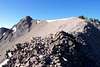
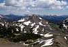
The summit of Hiram Peak lies only a few hundred feet within the Carson-Iceberg Wilderness and about one mile, and a thousand feet above Highland Lakes. Hiram lies on the ridge separating the deep canyons of Highland and Arnot Creeks. Its summit offers an excellent view of these drainages, along with the impressive pyramid shaped summits of Airola Peak and Dardanelles Cone. The Carson-Iceberg Wilderness is bounded to the north by SR4 (Ebbetts Pass) and SR108 (Sonora Pass) to the south. This area has far fewer lakes, and a corresponding far fewer people, than many regions in the Sierra Nevada. Much of the area consists of volcanic ridges and peaks, along with deep canyons. While most of the wilderness area sees very few visitors, Hiram’s close proximity to Highland Lakes insures that it does receive a few visitors during the summer months.The most common route to the summit begins from the eastern Highland Lakes Campground. A use trail can be found just above the upper most campsite. The trail climbs some 500 feet to a low spot on the ridge above the campground. Once this ridge is gained, leave the trail and head southwest and up the obvious sweeping ridge to the summit of Hiram Peak. While no harder than class 2, some references mention that the top of the ridge can give the acrophobic pause. This section is several feet wide, but falls steeply away on both sides. Those with prior off trail hiking experience should have no problems. One can tackle the short summit mass directly (very easy class 3) or head around to the left (north) to find a class 2 ramp to the top.
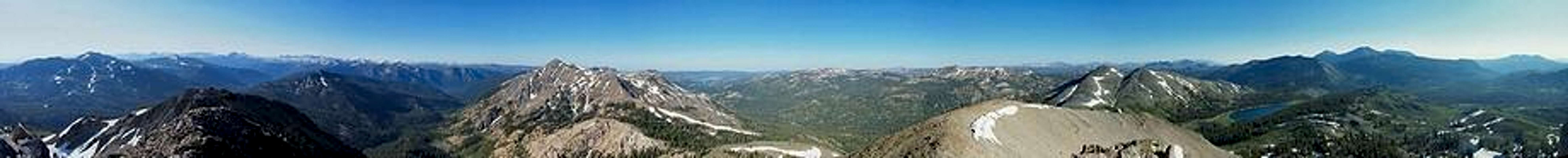  Hiram Peak full size panorama with labels |
 |  |  |  |
Getting There
CA SR4 from the west: Turn right (south) on Highland Lakes Road (8N01) about 16 miles past Bear Valley.CA SR4 from the east: Turn left (south) on Highland Lakes Road (8N01) about 1.3 miles past Ebbetts Pass.
Continue on Highland Lakes Road for about 5 miles to eastern Highland Lakes Campground. The last four miles of Highland Lakes Road is unpaved, and some sections are steep, but suitable for passenger cars.
Red Tape
Permits are not needed for day hikes. Permits are required for overnight stays in the Carson-Iceberg Wilderness.Wilderness Permit information.
When To Climb
June to November.CA SR4 is closed from the first snowfall (typically early November) to June. Highland Lakes Road typically opens in late June.
Other times of the year would require a very long snow approach.
Camping
Highland Lakes Campground is located at the base of the peak. Quick info: $12/night, 35 sites, hand pumped water, and pit toilets. The campsites are available on a first-come, first-served basis.Etymology
"Named for Hiram Tyre, who grazed cattle in the region in the early days." - Peter Browning, Place Names of the Sierra NevadaCattle still graze in much of the Carson-Iceberg Wilderness.