|
|
Mountain/Rock |
|---|---|
|
|
46.35444°N / 7.36055°E |
|
|
10656 ft / 3248 m |
|
|
Overview
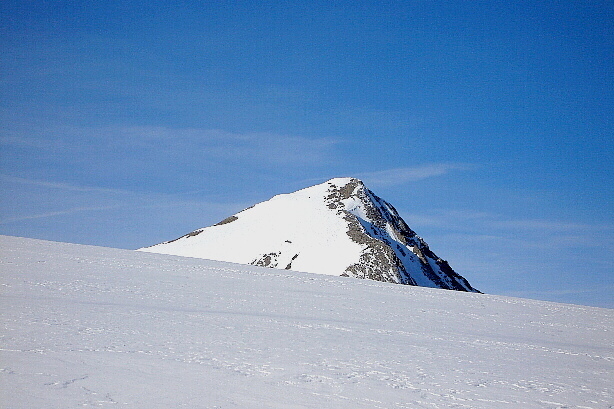
Wildhorn is in the western part of the Bernese Oberland. The only ice clad mountain that is located more west is Dablerets in the french speaking part of Switzerland. The water north of Wildhorn flows into the Rhine and to the North sea, while the southern part is part of the Rhone valley in Valais. The view from top shows all big mountains between Chamonix and Zermatt.Its popularity has two reasons: most routes are neither difficult nor dangerous, Wildhorn can be climbed on any sunny day of the year and is a paradise for skiers. Usually it is climbed from north, since there are no huts on its southern side. Sometimes a mountaineer skis down south, a long descent with possible use of the cable car of Anzére which amounts to more than three hours to get to Sion. Most skiers use the trail that touches the Wildhorn hut, although tough skiers start from a road near Lenk at 4 o'clock in the morning and crest the mountain within one day. Not ideal for skiing is the ascent to the Gelten hut, however the lovely lake and firs remind of the cascade. My recommendation: take your skis, start from Pöschenried above Lenk, spend a night in the Wildhorn hut and interrupt your descent from Wildhorn with an additional mountain: the Iffigenhorn. However, this can only be done with plenty of snow down to Lenk. March might be ideal.
If you do not ski and dislike walking on ice and snow, choose the Gelten hut and climb the northern ridge (Wildgrat), it is not very difficult, ideal for a beginner. The experienced climber chooses the northeast ridge (Nordostsporn) from the Wildhorn hut.
Those who prefer a Haute Route, that is less boring and more fun than the real one from Saas Fee to Chamonix, can start with the Diablerets mountain (cable car), and traverse all the western part of the Bernese Oberland via Wildhorn to the the Wildstrubel hut (2793 m) by foot or ski and end in Kandersteg or beyond.
Since the Wildhorn is so popular, it is also one of the 50 helicopter destinations that exist in Switzerland. Heli skiing is only allowed for tourists who hire a mountain guide (Air Glacier, airport of Sion).
Book: Berner Alpen, Vol. I: Diablerets bis Gemmi, Verlag Francke, Berne.
Alpne Skitouren, Vol. 4, Waadt-Freiburg-Bern, SAC-Verlag (german or french)
Map Nr. 5009: Gstaad-Adelboden 1:50'000 (probably your first choice, of all others you need 2 maps to cover all of Wildhorn.
Map Nr. 273 Ski Montana 1:50'000
Map Nr. 263 Ski Wildstrubel 1:50'000
Map Nr. 1286 St.-Léonard 1:25'000
Map. Nr. 1266 Lenk 1:25'000
See the Swisstopo Map with many interesting features. Upload is in a seperate window.
 |  |  |  |  |
Getting There
Wildhorn hut 2303 m, 93 places. Info: +41 (0)33 733 31 20Information
Starting point is the small town of Lenk (1064 m, railroad from Montreux and Interlaken, resort, camping, lifts, etc.). Follow the road to Pöschenried (1210 m) either by foot, car, taxi, bus (4 km). In winter and spring you have to decide, if you want to include the Iffigenhorn on your way down. If there is enough snow, I strongly suggest to do so and leave your car at Pöschenried and walk ca. one hour on the road to Iffigenalp (1564 m). If not, you can take the car and park at Iffigenalp. The road is kept open by the Swiss army all year round, but you can only leave Pöschenried at h.15-30 every hour (one way traffic). In the morning at 4 o'clock nobody cares about this rule.
From Iffigenalp walk either through the valley along the steep walls of Schnidehorn (avalanches after snowfall and high temperature!) or climb the safe crest of Egge (10 min. longer), go down the the lake and head for the hut. 2-3 hours from Iffigenalp.
Iffigenalp In summer only. Dorms, rooms, food. See several links around Lenk
Gelten hut 2002 m, 89 places, Info: +41 (0)33 654 28 84.
Starting point is Lauenen 1241 m, bus from Gstaad, hotel, store, restaurant. There are 2 paths to the hut.
a) Road to the lake (restaurant). From there follow the path near the creek. Sometimes used in winter on safe days. 3 hours.
b) Soon after Lauenen, the path quits the road and stays on the right (east) side of the valley. Partially exposed, ladder. 3.5 hours.
 |  |  |
Red Tape
No parking fees at relevant places. No camping near hut, this is true for all Switzerland!Getting To The Top
Normal route from LenkI describe the tour for skiers, but it is similar for hikers. Crampons and axe can be a help in summer, generally not necessary in spring.
From the Wildhorn hut (2303 m) walk to the foot of the Kirchli. Then turn left and step on the Tungelgletscher as high as possible (foot: if the glacier is icy, it may be easier to climb west of Kirchli). Behind Kirchli you can easily reach the top of Wildhorn either directly on its northern slope on the Tungelgletscher or you can keep southeast and head for point 2912 m.
Use your judgment. I like that point, since it opens the view to the Weisshorn etc. and this fantastic view gives me an additional push. If the crowd gets on my nerve I turn left and climb the easy Schnidehorn (2937 m) instead where I can enjoy the quiet nature completely by myself and watch the Wildhorn skiers (see photo).
Descent back to Wildhorn hut anyway you like. Below the hut is a white flat place, in summer it is the Iffigensee (2065). Either you climb the small saddle or hill you came from and head for Iffigenalp or crest the Iffigenhorn (2378 m) in 1 hour. Ski down the wide crest Hohberg. At ca. 1900 m, turn left, cross the small valley and keep on the left side and reach finally
Pöschenried (1210 m).
Please read also the Info by stucky!
 |  |  |  |  |
stucki - Aug 11, 2003 9:18 am - Hasn't voted
Untitled CommentHi,
I'm just back from a fantastic trip via Les Diablerets, Wildhorn, Wildstrubel. We experienced serious problems to get to the south (or west?) Wildhorn summit due to the very warm spring and summer like this year 2003 when the snow retreated to elevations of 3200 m and more. We hiked the summit via the small ice field between both summits. It was fairly steep, slip out could be very, very harmfull! Securing is absolutely necessary, if you are not an experienced mountaineer!
Stucki
Mauntainfreak - Jan 15, 2016 4:20 am - Hasn't voted
Skitour to WildhornThis is a photo-gallery of a skitour to the Wildhorn. (click the photo):