
|
|
Mountain/Rock |
|---|---|
|
|
45.25900°N / 117.264°W |
|
|
9775 ft / 2979 m |
|
|
Overview
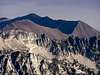
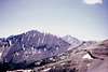
Hurwal Divide is the southern continuation of the escarpment which forms Chief Joseph Mountian in the Wallowa Mountains of northeastern Oregon. The summit of Hurwal Divide is 1.8 miles nearly due south of Point Joseph, the summit of Chief Joseph Mountain. The two summits (Joseph and Hurwal) are separated by a fault which runs approximately east-west at Twin Creek. Hurwal Divide's surface geology consists of crystalline limestone, shale, and some conglomerate consistent with the Martin Bridge formation, but this geology is not obvious as most of the mountain appears to be a pile of scree.
The name "Hurwal Divide" derives from the fact this ridge separates the Hurricane Creek drainage on the west ("Hur")from the Wallowa River drainage, including Wallowa Lake, on the east ("wal").
The summit of Hurwal Divide is higher than Point Joseph, but ascents are rarer because it's a long hike compared to it's more romantically named neighbor to the north. Although the slopes are steep, moderate ridges offer several non-technical ascent options.
Mountain goats are common on the slopes in this area.
 |  |  |  |  |
Getting There
There are two main accesses to ascents of Hurwal Divide, although several other alternatives and variations are possible.
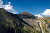
The first access uses the Hurricane Creek Trail. From the town of Enterprise, Oregon, go south on Hurricane Creek Road. Stay right (which is still Hurricane Creek Rd) at the Hurricane Grange. Drive past the Hurricane Creek campground to parking at the end of the road. The Hurricane Creek Trail starts at the parking lot. Follow the Hurricane Creek trail to the Thorp Creek trail (shown on USGS map, but not USFS maps). The junction is actually near where Twin Creek intercepts Hurricane Creek. Follow the Thorp Creek trail to the upper valley of Thorp Creek between Hurwal Divide and Sacajawea Peak. Several possible summit routes, all non-tecnical, are available from this valley.
The other main access is via Joseph to Wallowa Lake. One can use the Chief Joseph Mountain trail to ascend Point Joseph, then stay on the ridge south to the Hurwal Divide summit.
 |  |
Red Tape
A Northwest Forest Pass is required for parking at the trailhead. These are available at most US Forest Service offices ($30 for annual pass in 2002)
Self registration (free) at the trailhead is recommended for overnight trips into the Eagle Cap Wilderness Area. (This permit is not the same as a Northwest Forest Pass.)
Wallowa-Whitman National Forest
When To Climb
Ascents are possible year around. The ridge south of Twin Creek on the western slope provides a possible winter route relatively free of avalanche danger.
 |
Camping
There are numerous potential campsites in the Thorp Creek valley between Hurwal Divide and Sacajawea Peak.
A primitive campground is located at the Hurricane Creek trailhead.
A fully developed state park campground is located at Wallowa Lake.
Wallowa Lake State Park
Mountain Conditions
The US Forest Service has a Wallowa Mountains Visitor Center in Enterprise. (541) 426-4978
 |
Height Ranking
Hurwal Divide is ranked as the 7th highest summit in Oregon by Jeff Howbert's Oregon's Highest 100 Peaks
It is not listed in Oregon Highest Named Summits presumably because the name Hurwal Divide seems to apply to the entire ridge rather than the high point.