
|
|
Mountain/Rock |
|---|---|
|
|
37.12220°N / 105.185°W |
|
|
14047 ft / 4282 m |
|
|
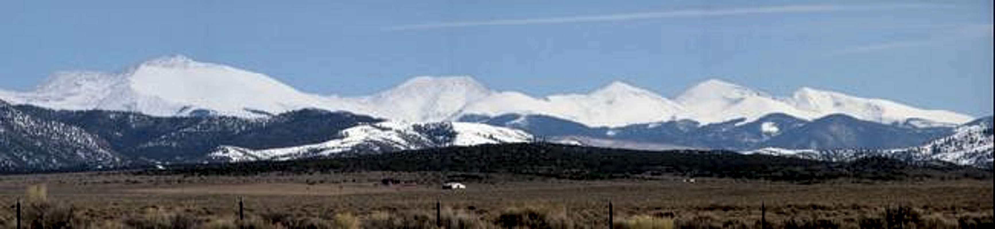 Excellent view of (L to R) Culebra Pk, VermejoPk, "Alamosito", Purgatoire Pk, and Pt 13,265. (Red Mtn is behind Culebra's ridge)
CULEBRA PEAK ACCESS
Hope everyone is having a great season.
For reservations use their website:
Cielo Vista Ranch
Email is preferred CVRProperties@hotmail.com
Climbers welcome Fridays & Saturdays through August.
Maximum group size is capped at 25/day.
Email if Mid-week climbs are desired.
$150 p/p for Culebra and/or if Red Mtn is desired.
OVERVIEW OF CULEBRA
Culebra, which means "harmless snake" in Spanish, is one of the most, if not the most, historic fourteener in the state of Colorado with documents dating back to 1694. It is a unique peak and probably the most controversial peak in the state. This area has only been owned by either the early Hispanic settlers or, until the last 140 years, by Americans. The National Forest Service, and/or the US Government, has never managed this land.
This expanse was quite peaceful, until 1960, when perceptions changed and hikers no longer had free access to the area. Anyone who wanted to hike in the area had to pay a fee and follow rules. So people either: ignored the peak and left it off of their lists, criticized and paid the money, or wanted to ‘blow’ fifty feet off the mountain and make it a thirteener. These perceptions still continue today. The fact of the matter is, if people have intentions of legitimately completing all of the official fourteeners in Colorado, they will have to follow the simple rules (our world is full of rules what are a couple more going to hurt?). Eventually, people will hike this peak and officially be able to say, honorably, that they have completed all of the states’ 54 (55 Challenger) highest peaks.
As of Sept. 2004 the ranch was sold to a Texas couple who is now allowing acces on the mountain, for a fee of course. From 2001 through 2004, only the Colorado Mountain Club (CMC) was allowed one weekend a year access to the peak. Of course, this could change and the rules have been altered numerous times over the years. The old owner of the property (1998-2004) cut off total access to the area leaving it to undeveloped wilderness. Other than the one weekend that was allowed to hike Culebra Peak, access to other peaks in the area, including Red Mountain Culebra’s sub-peak and a centennial peak, were off limits. Other well-known peaks that were also off limits include the two bi-centennial peaks of Vermejo Peak and Purgatoire Peak. If you look at a map, or are familiar with the area, anything south of Cuatro Peak (13,487) which is about four miles south of the more famous Trinchera Peak (13,517feet, #245) all the way into New Mexico are, basically, on private land. Topozone
 |
 |
 |
WHERE IS THE PEAK LOCATED
Culebra Peak, missing the border by only nine miles, could have been New Mexico's highest peak. Instead it has the honors of being the Southern most fourteener in Colorado. It is located east of the town, San Luis, in the Sangre de Cristo Mountain Range (the longest range in the Rocky Mountains, spanning over 150 miles, starting near Salida Colorado and ending near Santa Fe New Mexico). USGS 7.5' map - Culebra Peak Colorado
 |
 |
 |
 |
GETTING THERE
The standard and only legal trailhead is at 9,240 feet which accesses Culebra's west slopes. From the town of San Luis on Colorado 159 turn southeast onto road P6 (fourth street). Once in the town of Chama turn left (east) on road L7. Then turn right (south) onto road 22.3 and cross Culebra Creek. Finally turn left (east) onto road M5 follow the road as it will turn to a dirt road. After this point you will run into the Cielo Vista (formerly Taylor Ranch) gates.
 |
 |
 |
AREA LODGING/CAMPING
The town of San Luis has a hotel and a couple of Bed-and-Breakfast establishments.
San Luis area Lodging Guide
Alamosa has a KOA and numerous hotels.
Alamosa Visitor Information Center
As for National Forest campgrounds the closest would probably be near the town of Cucharas and the Spanish Peaks on the other side of the range, they are Bear Lake and Blue Lake CG.
Forest Service Campground List
Great Sand Dunes National Monument has 88 camp spots.
They are available on a first-come, first-serve basis.
Sand Dunes web site
Lathrop State Park near Walsenburg has 100 campsites.
Lathrop S.P. web site
The Como Lake Road is in close vicinity and is a wonderful camping area but for the better spots you will need a high clearance vehicle.
NEW MEXICAN LAND GRANT HISTORY
To better understand Culebra Peak and Ceilo Vista (formerly Taylor Ranch), it is important to understand Mexican Land Grants.
1598 was the beginning of Hispanic New Mexico. Settlements grew slowly from Santa Fe in all directions. The first step in acquiring a grant of land, in those days, was to verify that the land was vacant and that it wasn’t occupied by Indians. The first land grant was written to Jose Trujillo in 1700.
New Mexican land grants fell into two general categories of either private or community.
Private: land grants were written to one individual, male or female, who owns the entire grant and can sell it after meeting possession requirements. One example of possession requirement is living on the land for at least four years.
Community: land grants were given to one primary owner, and as a result, designated this land to multiple holders on the condition to improve the land through development or risk loosing their property. In addition communal land grants could not be sold by any group or individual under Hispanic Law. The pobladores, or “town’s people”, received an irrigable plot of land to build an adobe home and/or small farm, using any addition land included in the plot, for livestock grazing, etc. The additional land not plotted for development was considered as the common lands, land utilized by the entire community for the purpose of providing resources. Common land resources included: pasture, logging, collecting firewood, hunting, fishing, quarrying, etc.
Each pobladore had equal rights to water. The welfare of the all, including the improvement of land, depended on access to this resource. Membership in a land grant was highly prized because it provided security, identity, and status in the community. The practice of operating land grants, primarily community, continued until the early 1850s (about the time when the United States took control of the area). Ultimately, land grants depleted with records of individuals or groups beginning to sell their shares.
How the borders were established: The Spanish-Mexican land grants did not use a grid system similar to the United States to establish borders. They plotted land claims by using geographical points such a rivers, mounds, and mountains.
1848: After Mexico was defeated in the Mexican-American War, the United States government and the Mexican administration signed the Treaty of Guadalupe Hidalgo. This treaty guaranteed ex-Mexican citizens their private property rights against the new United States government. Subsequently, the American government and lawyers found ways around the treaty and, although it didn’t happen to all of the Mexican land owners, much of their land was ultimately seized.
1854: William Pelham was selected as the first United States Surveyor General over the depleting Mexican land. His appointment to power intensified land fraud and commenced Congress to exhibit a lack of concern for honoring the Treaty of Guadalupe Hidalgo. The owners of the land grants feared that Congress had no intentions of stabilizing land titles in New Mexico. Future events were to prove these fears. An example of ignorance, and there are numerous examples, exploiting the treaty was in 1861. The San Joaquin land grant was a communal grant that was awarded in 1806 and numbered about 400 residents. They petitioned the Survey General for confirmation of their grant, which was estimated to contain about 184,000 acres. The petition was ignored for seventeen years, which was a basic strategy, to string out the process as long as possible. When the survey was finished in 1878 the acreage of the San Joaquin was listed at 473,000 acres not the approximated 184,000. Seventeen individuals protested the survey stating that their private land grants were included in the survey and confirmation of the grant will rob them of their land. While the land grant was being contested in New Mexico, William Blackmore was trying to sell the land, inside the grant, to people in England. In 1896 the Supreme Court ruled that the San Joaquin community was now owned by the United States.
Other reasons for loss of land included investigations from the Survey General. He would scrutinize the authenticity of a particular land grant. If the Survey General found that the land was unoccupied, or wasn’t improved over it’s time of inception, it would be turned over to other acquiring interests, such as lawyers and judges. Although, if proven that it was occupied with improvements made, they were able to keep their land.
There are so many examples from this time in history, I could write a ten page report, but after careful consideration, I will leave it at that. If you are interested in more information here is a great web site. land grant history
 |
 |
 |
 |
CULEBRA PEAK HISTORY
Culebra Peak is one of the last pristine wilderness areas in Colorado. The main reason for this is due to the trespassing limitations. There has not been free access to the area for over forty-three years. This peak is rich in history and can best be explained in a timeline format. Sticking to the main facts as much as possible, and it is a possibility, if not an absolute, that a few key fact and/or items have been missed, please remember the purpose of this outline is to keep it short.
In the Beginning:
1400’s: The Comanche, Jicarilla Apache, and other tribes visited the San Luis Valley to hunt buffalo and antelope, while the Ute Indians seasonally occupied the area.
1694: Diego de Vargas, in his journal, made a short reference to the landscape and wildlife of the “Rio Culebra”. This is the earliest written reference to the area.
1779: Juan Bautista de Anza constructed a map of the New Mexico territory which included the Rio Culebra by name.
1807: Zebulon Pike entered the San Luis Valley in the winter and wrote of a “large road leading eastward to the vicinity of the Rio Culebra”. Pike’s maps also cited the Rio Culebra by name.
The Sangre de Cristo land grant
1843: On December 27th, Narciso Beaubien and Stephen Lee were awarded a 1,038,195 acre track (about the size of the Grand Canyon National Park) and was named the Sangre de Cristo land grant. Its borders, today, are now Costilla County Colorado. Beaubien and Lee told Governor Manuel Armijo that the land was fertile and had an abundance of pasture and water. As a result, he granted it to them as a communal land grant.
Carlos Beaubien, Narciso’s father and Stephens son-in-law, was already granted the Beaubien-Miranda (Maxwell) land grant (over 1,700,000 acres) in 1841. Between them, the Beaubien family held nearly 3,000,000 acres of land. The Maxwell land grant is to the east of Culebra Peak. It's borders, today, are basically the Las Animas-Costilla County line. The majority of the Maxwell land grant was in New Mexico, and some of the land encroached into the Taos (Pueblo) Indian's land. This infringement upset the Indians and eventually lead to the Taos uprising. In 1847, the dealings about how the family received their land, lead to the killing of Narciso and Stephen by the Taos Indians.
Carlos inherited Narciso’s holdings while Lee’s part of the estate was in debt. Consequently, Stephens’s administrator was forced to sell his half to Carlos for only $100. Although it took a little time and some persuading to get settlers to come, Carlos was an effective landowner and started a variety of agricultural settlements along the Costilla and Culebra Rivers. The first community established was Garcia CO, which today is about one mile north of the New Mexico border and one mile west of CO Hwy 159. Other communities followed like San Pedro (1850) and San Luis (1851) Initially, inhabitants first called this area La Plaza Medio and then renamed the vicinity San Luis de la Culebra. This was the center of village establishment. Other communities were San Pablo (1852), San Acacio (1853 the smallest village), Chama (sometime after 1863), San Francisco (1853-4), and Los Fuertes. All of the communities are listed in the DeLorme Colorado Atlas and Gazetteer. The community (all the villages) used the entire grant including the high mountains (i.e. Culebra Pk) that they called “la Sierra”.
1848: The Treaty of Guadalupe Hidalgo is signed. (Ref. history of New Mexico)
1852: Carlos signed a 25 year lease with the United States Army in the creation of Fort Massachusetts, six miles north of today’s Fort Garland. This fort was ineffective in keeping the Utes away from the villagers, and as a result, in 1856 the Army moved the Fort and called it Fort Garland. It is still there to this present day. The villagers relied on the Fort for protection from the Utes. This safeguard eventually lead to the pacification of the Indians and ultimately their removal to Western Colorado in 1868.
1856: William Pelham, the Survey General, started an investigation to the authenticity of the large land grant, but only after two days the court ruled that the land was occupied from it’s inception to the present day and the Beaubien family was allowed keep their large land grant. In 1860 the Sangre de Cristo land grant was recorded as an act of Congress.
1860: 1,724 non-military residents (US Census)
1861: The Sangre de Cristo land grant became a part of the Territory of Colorado, and also became one of the original seventeen counties.
1862 & 63: Carlos formalized 135 deeds to the pobladores. It outlined the rights and responsibilities of the settlers.
1863: An ill Carlos sold his land holdings to Colorado’s first Territorial Governor William Gilpin for $41,000, or 0.04 cents an acre. At the time of the sale, Gilpin signed a document affirming Carlos’s agreements with the original settler’s customs and traditions of the land to be protected. This agreement also allowed the villagers access to the “la sierra”, no matter who was to be the future owners.
However, Gilpin had a capitalist agenda and divided the Sangre de Cristo grant into two halves, the Northern Trinchera and the Southern Costilla. Also, he instituted taxes and promoted the vast lands to the Dutch and English immigrants. As a result, the new owners and Gilpin started treating the original settlers as trespassers.
In spite of this, Gilpin’s plan was unsuccessful and the mass amount of people never came as he had hoped. He offered one-third of the grant to General William Palmer, owner of the Denver and Rio Grande Railroad, and in 1878 the railroad made it to the land grant. In return, the railroad claimed fifty feet of land on both sides of track, was offered land for depots and shops, and was given an acre for every five miles of track laid.
During this period of time the taxes were increasing and the area was moving more to a cash economy instead of the previous bartering economy. This economic swing forced the villagers to seek employment outside the farm. They worked for the D&R railroad, hauled freight to the mines, became agricultural labors, and worked on large cattle ranches for the European immigrants. The times were equally tough for the pobladores as they were trying to adapt to another culture while many were going broke. Some were forced to sell there water rights to pay off their debts. Others sold off there livestock and sheep. Some even lost their land to creditors.
The 1870 census recorded 157 farmsteads and by 1880 the number fell to 73. This decline was the result of Gilpin and his legal challenges before the Colorado Supreme Court against the original settlers. Gilpin and his partners incorporated the United States Freehold Land and Emigration Company (USFLEC). They wrote up documents for the settler’s to sign their common land use privileges away by using an imposter disguised as a homesteader. This subsequently got the USFLEC a resurvey and permission to obtain a patent to the new survey. By the time the survey was complete some of the original residents had already abandoned their small homesteads and mining claims and left the region. The USFLEC took rights to the vacant land and resold it to the now larger ranch owners.
By 1910 most of the Beaubien’s communities disappeared.
1902: The tax delinquent USFLEC relinquished its remaining holdings via a county tax sale. The tax sale served two purposes but most importantly, it was an attempt to use the tax sale to remove the 'cloud' over the grant title. By purchasing and reselling the tax certificate multiple times, the USFLEC theoretically rid the new owners of any responsibility to the Beaubien claim. They sold the last holding to Colorado Springs investors.
The Costilla Estates Development Land Company began and, with no success, they tried to keep the pobladores from exercising their traditional rights to the “La Sierra” and even challenged their water rights to the lowlands.
1930’s: The great depression hit and the villagers used what they needed from the land and made it through the tough times. The new residence, in Lou of failed banks and water shortages, retreated in mass abandonment of the new towns.
Delfino Salazar owned a century-old general store (built in 1887, burned twice, rebuilt and is now called R & R Market) in San Luis slowly bought land in the area, including Culebra Peak. Delfino graciously allowed climber access to the peak and often gave entertaining campfire talks on the history in the area. In 1958 Delfino Salazar dies which marks the end to an era of Culebra free use history. THEN
1960: Jack Taylor a lumberman from North Carolina bought the 120 square mile tract for $500,000 from Denver businessmen. In the deed, that he signed, it contained a caution. This warning stated that his title was subject to possible claims, of the local people, to their right of pasture, wood, and lumber. But instead, he fenced, barricaded roads, forbid access to his land, and would assault locals caught trespassing. To Taylor, the claims of common-use rights to the land, which his neighbors were exercising for generations, was a failed result of the land owners' not taking charge of their private property. Although the local residence continued to use the mountain tract, Taylor and his armed guards continued to run them off and confiscate equipment. These actions sometimes alluded to violence, one of which included his bulldozer shot full of holes.
1965: Judge Hatfield Chilson ruled in favor of Taylor’s sole title to the land. Then Taylor quietly then went and registered his title under Colorado’s Torrens Act. This provided the registrant with virtually unassailable ownership.
1975: Several bullets ripped through the roof of Taylor’s house and one bullet shattered his ankle. After that incident Taylor left the area and never came back.
1981: A class action lawsuit (Rael vs. Taylor) was brought against the Taylor Ranch. At issue was whether Taylor properly notified everybody who had a claim to the land in his 1965 'quiet' title suit. The Colorado Supreme Court voted 4-3 against the plaintiffs (Rael), but such a close ruling gave them hope for a future overruling.
1988: Jack Taylor died and tensions eased considerably. Jack’s son, Zachary Taylor, was the executor of his estate. He said, “after Jack left his land he was pretty upset that he couldn’t enjoy his property. He couldn’t get any law enforcement officials to enforce the law. He was an outsider”. After his father death, Zachary hired Jim Cockrum an ex-sheriff to run the ranch. Jim, at Zachary’s request, was more open to local request since the previous ranch manager was murdered. At the rate of $5 a pick-up load, he opened the ranch to the local people, increased local grazing leases, while the proceeds went to a local non-profit group. He also opened the ranch to camping on the Fourth of July.
? - 1988 - 1995 Hiking Culebra:and other peaks in the area was permitted on Saturdays in July and throughout the Fourth of July weekend. $20 per person. On the Fourth of July weekend camping was permitted. The trailheads were at the upper parking lot at around 11,500’.
1990: Governor Roy Romer, Zachary Taylor, and his two sons had a meeting in Alamosa. The Governor asked them to donate the ranch. The Taylor’s declined. Then, Romer suggested that they sell it to a non-profit or public agency, which worried the Taylor’s that a public agency wouldn’t give them fare market value. Finally, purchase of the land began to take shape between the forest service, a conservation fund, and the Taylor’s. Zachary Taylor made a good effort, but it fell apart.
1991: The original settler descendents went back to court with to appeal to the ruling of Rael v. Taylor and lost for the second time. The court ruled that Taylor’s land, is Taylor’s land.
1992: The ranch grossed $300,000 from hunters.
May 1993: Taylor went fishing for a private buyer and found Tim Blixseth president of Oregon Timbers . Next, a mysterious fire burnt Jack Taylor’s house to the ground, the same house that Jack was shot in. After that Blixseth backed out of the sale.
September 1993: Governor Roy Romer established the Sangre de Cristo Land Grant Commission which included trying to gather 22 to 32 million dollars, mainly in bonds, to buy the Taylor Ranch and turn it into a state park to be managed by state and local officials. Taylor signed a letter of intent to negotiate with the state if his other buyers fell through.
March 1994: The state offered Zachary Taylor 15 million dollars to purchase the land. This was rejected.
March 1995: The Taylor Family signed a contract with Stone Corporation to timber cut 12% of the southern end of the property which concerned the locals on their watershed affects.
1996: Hiking access to the peaks increased to $40 per person. Hiking access is increased to the months of June-August.
1999: Former Enron Executive, Lou Pai, purchased the Ranch for 23 million. The purchase was made, with money the Securities and Exchange Commission maintains, Pai obtained between 1997 and 2000 from 'cashing out' 353.7 million dollars of Enron stock, more than any other Enron Executive. Lou has also cut off total access to the area leaving the area to undeveloped wilderness.
1999: The Colorado Mountain Club (CMC) wrote a letter to the owner on the east side of Culebra Peak for a possible hike. Their attorney returned the letter that stated the owner has no interest in climbers, at all!
Nov 1999: The State of Colorado decommissioned the Sangre de Cristo Land Grant Commission.
2000: No hiking was allowed
2001: The CMC is granted hiking access on the Taylor Ranch for Culebra Peak. The hike is limited to twenty-five members, but the other peaks in the area are not accessible. Also, the upper parking lot is no longer accessible to 4wd vehicles. Everyone must start at the Ranch office and be back by nightfall. Cost $25 per person
Feb 2002: Former Enron investors and employees are trying to recoup their losses and are looking at the historic Taylor Ranch as a target. If they win, or even pursue this, it’s unlikely that they will want to divide the land up amongst themselves. The Federal Land and Water Conservation Fund is now a potential buyer.
June 2002: The Colorado Supreme Court ruled that the land grant heirs do have rights to the 77,000 acre ranch. The court restored partial rights to descendants of the original settlers by granting access to the land for grazing, firewood, and timber gathering. This ruling, though, doesn’t include recreational access.
Aug 2002: The CMC is allowed two groups of twenty-five people each to hike Culebra Peak. Although, other peaks in the area are still off limits. Cost $25 per person
Sept 2002: Due to the popularity of the August hikes, the CMC is granted one additional day for some of the people who didn’t get picked for the August hikes.
Aug 2003: The CMC is allowed three groups of twenty-five people each to hike Culebra Peak. Although, this time Red Mtn was included on one of the days. Cost $25 per person
June 12, 2004:District Judge Gaspar Perricone on Friday reopened the gates of a 77,000-acre ranch to descendants of the original San Luis Valley settlers, after 44 years of court battles. In a hearing lasting less than an hour, Judge Gasper Perricone told a packed Costilla County courtroom in no uncertain terms that the heirs to the Sangre de Cristo Mexican Land Grant had won the case. Nine plaintiffs, including the so-called “Magnificent Seven,” their attorneys and supporters, immediately went onto the ranch, looking at the terrain they are finally able to use for grazing and wood gathering.
Aug 2004: The ranch was sold to a Texas couple for an undisclosed amount. The name of the ranch has been changed to Cielo Vista and are now welcoming hikers back to the area. Cost $100 per person, minimum of 5 people per group.
If anyone has any additional information pleas email me at grants@joaquinmc.com
Bibliography
High Country News; October 18, 1993; A Lost land grant; Can it be reclaimed?
Delorme Colorado Atlas and Gazetteer, Fifth Edition, 2000
Land Grant History, 1999, Ruben D Salaz
Colorado Sate Archives; June 4, 2001; Spanish-Mexican Land Grants
US Department of the Interior; August, 1986; The Culebra River Villages of Costilla County, Colorado
pictures Library of Congress Prints & Photographs Division Washington, DC 20540
http://www.rootsweb.com/~cocostil/p
proof read by Lisa, THANKS!!!
External Links
- Culebra Peak & Red Mountain
- Culebra Peak/Red Mountain (09/23/2004)
- 14ers.com - The Home of Colorado's Highest Peaks
Fourteener Photos, Route Descriptions, Forum, and more...
Thanks Mr. Hill.....for allowing us hikers back.....
The Lower Marmot - Aug 10, 2004 1:16 pm - Voted 10/10
Untitled CommentHow could Sunlight Spire be official with only 215 vertical from Sunlight? I understand that it's difficulty means the 215 might as well be 2,150, but if that's the standard we used to determine what is and isn't an official 14er we could pull a bunch of established 14ers from our list and add a bunch of gendarmes with 50 feet of elevation gain from the nearest higher peak.
Aaron Johnson - Apr 8, 2003 6:44 pm - Voted 10/10
Untitled CommentPerhaps more than any mountain in America, Culebra's complex history is very important in helping climbers understand why things are the way they are. Many mountains have controversial histories, but Culebra takes the cake.
History affects us all in ways we may not be aware of or understand. The fate of mountains are carelessly handled by the greedy and thoughtless quite often. It makes me thankful for the Forest Service and Wilderness Areas to prevent such tragedies.
SP can serve in an educational capacity as well as a mountaineering capacity. What a great resource, particularly to warn climbers of likely problems they will encounter in such situations. Grant-thanks for going to the trouble to prepare this in-depth report of Culebra's history and uploading some historical shots. May we all have a better understanding and tolerance for this sad situation in the end. Well done!
xskier77 - Aug 6, 2004 11:16 am - Hasn't voted
Untitled CommentI spoke with the CMC this week and they told me there is no lottery this year. They will be taking people that have been on the list in past years and not been able to get on the trip. The dates are August 27,28, and 29.
I have been working hard to hit the 52 mark all summer and now that I'm at 52 I will have wait a whole year before I will even have a chance to do Culebra. Culebra should be off the list of official 14ers.
The Lower Marmot - Aug 10, 2004 1:16 pm - Voted 10/10
Untitled CommentHow could Sunlight Spire be official with only 215 vertical from Sunlight? I understand that it's difficulty means the 215 might as well be 2,150, but if that's the standard we used to determine what is and isn't an official 14er we could pull a bunch of established 14ers from our list and add a bunch of gendarmes with 50 feet of elevation gain from the nearest higher peak.
Kiefer - Aug 16, 2006 2:59 am - Hasn't voted
New BetaThis new information is valid as of 7.03.06 The owners of Cielo Vista ranch down by San Luis are now allowing us hikers access to camp just inside the main gate (North Headquarters) for the night before. They ARE NOT charging any fee for this AND they have provided a Port-O-Poty at the gate as well. The actual gate is locked until check in time the morning of the climb but just step over the gate and camp anywhere within 150 yards of the gate. You must check-out no later then 6:00pm (18:00).
seth@LOKI - Jul 6, 2015 6:27 pm - Voted 10/10
Thanks for the HistoryThanks for going into the history and posting this. Nice work. I love SP.
seth@LOKI - Jul 6, 2015 6:30 pm - Voted 10/10
CAMP AT GATE AS OF 7/4/2015UPDATE: YOU CAN STILL CAMP AT THE GATE FOR FREE. PORTA-POTTY AND TENT SITES - JUMP THE GATE. Most slept in vehicles. We were worried about this and got no response via email about camping.