Overview
![Guajara]() Guajara as seen from the main summit of the Roques de Chavao
Guajara as seen from the main summit of the Roques de Chavao
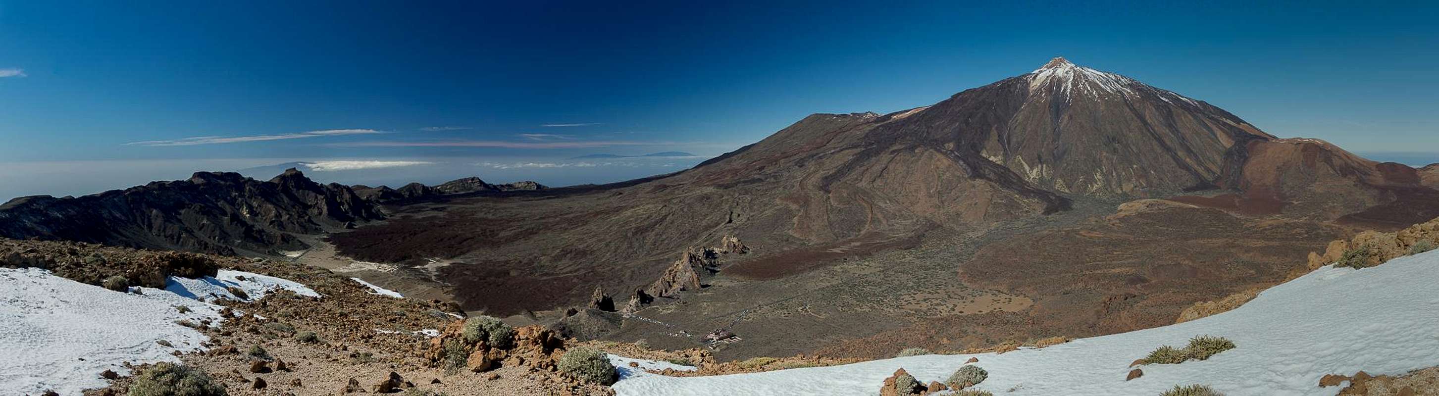
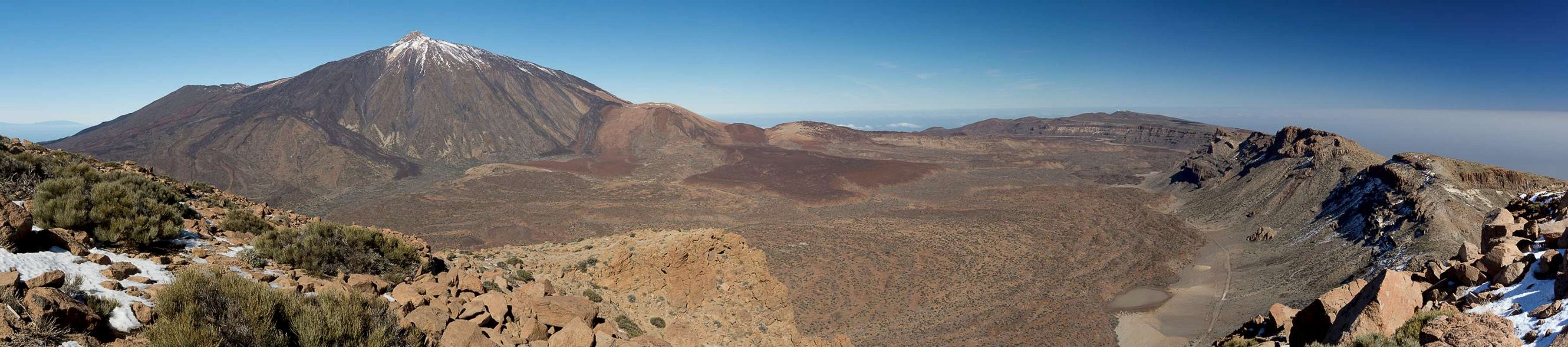
Guajara is the highest mountain within the "Cañadas border range", which surrounds the Cañadas del Teide and Teide itself. It provides a phantastic view to all Tenerife mountains, the coast line, the ocean and the neighbouring islands. The summit can be rather crowded since a lot of tour groups climb it together.
The mountain is quite bulky, steep on the inside of the crater (its north face), shallow on the outside. The top is a huge plateau, which often is swept by very fierce winds. Also, Guajara is one of the few mountains on Tenerife, on which you can find snow during the winter months and late into spring, especially on the ledges in the north face.
There are two rather easy routes to the summit, one over the pass Degollada de Guajara, the other along a narrow ledge through the north face of the mountain. Tour books will tell you that this ledge is rather difficult and exposed but actually the exposure is minor due to its average width of some two meters.
Summit Views
Guajara summit view across the western Cañadas del Teide |
Guajara summit view across the eastern Cañadas del Teide |
Getting There
![Guajara]() Guajara as seen from east of Lomo de las Mesas
Guajara as seen from east of Lomo de las Mesas
As one of the major european vacation getaways Tenerife can be reached from all major European airports. There are almost no regular flights but lots of charter flights. On Tenerife there are two international airports, one at Santa Cruz in the east, one at Los Abrigos in the south.
You can reach the Cañadas del Teide from all four directions. Just drive as far upwards as you can and you'll be there. From the south there is a road from the airport via Villaflor to the Cañadas, from the West you must head for Chio either from Playa de las Americas or from Santiago del Teide. The northern road starts from Puerto de la Cruz and the eastern ascent starts from the capital Santa Cruz del Tenerife and crosses the mountain range Cumbre Dorsal.
Alternatively you can take the bus either from Playa de las Americas (Line 342) or from Puerto de la Cruz (Line 348). Both buses depart at about 9:00 a.m., the return buses go around 4:00 p.m.
Red Tape
![Guajara (2715m) and Piedras Amarillas]() Guajara and Piedras Armadillas
Guajara and Piedras Armadillas
No permits, no fees, no closures.
But behave as usual within a National Park!
You should know that even the marking of hiking trails is not allowed in the Canadas del Teide. So whenever you meet somebody who ist painting green (!) dots to mark the trail - be kind, because he risks annoying the park rangers adnd getting bagged (at least temporarily)!
When To Climb
Hiking is possible all year round but bring the appropriate gear in winter, especially if you want to climb the rock ledge either ascending or descending.
Accomodation
Of course you can find a lot of hotels, fincas and casas on the island which you can book from any travel office. The Cañadas del Teide are a natural park so there is no camping allowed. You might use the Parador Hotel which is supposed to be quite expensive, however. Better stay at one of the hotels at sea level and drive up by rental car or bus.
Weather Conditions
There are several sites on the web which give you information on the weather on Tenerife. However, they all show the weather for the coastal regions (Puerto de la Cruz) which significantly differs from the weather in the Cañadas del Teide. The following table shows data for Puerto de la Cruz on the coast.
| Month | Jan | Feb | Mar | Apr | May | Jun | Jul | Aug | Sep | Oct | Nov | Dec |
| Avg. day temp.[°C / °F] | 19 / 66 | 19 / 66 | 20 / 68 | 21 / 70 | 22 / 72 | 23 / 73 | 24 / 75 | 26 / 79 | 26 / 79 | 24 / 75 | 22 / 72 | 20 / 68 |
| Avg. night temp.[°C / °F] | 13 / 55 | 13 / 55 | 14 / 57 | 14 / 57 | 16 / 61 | 18 / 64 | 19 / 66 | 20 / 68 | 20 / 68 | 18 / 64 | 17 / 63 | 14 / 57 |
| Water temp.[°C / °F] | 19 / 66 | 19 / 66 | 19 / 66 | 19 / 66 | 20 / 68 | 20 / 68 | 22 / 72 | 23 / 73 | 22 / 72 | 22 / 72 | 21 / 70 | 20 / 68 |
| Rainy days | 10 | 7 | 8 | 4 | 3 | 2 | 1 | 1 | 3 | 5 | 7 | 9 |
The Canarian Islands (as well as Madeira) are located in the trade wind zone. You almost always encounter northeastern winds which carry a lot of humid air. Being forced to climb to higher altitudes this moisture condenses into clouds. This in return means that most of the time the northeastern part of the islands is covered in clouds from altitudes of 1000m through 2000m.
The mountains themselves - being mostly of the same altitude -finally stop the clouds so that on their southeastern slopes the clouds "run out". In the case of Tenerife the Cañadas del Teide are so high that rarely ever do you encounter fog or clouds. This on the other hand means that the whole area is very dry so be sure to bring your own water.
The southern part of Tenrife rarely gets any rain which is why most of the beaches have been established there. The best hikes on the Island are in the Cañadas or in the northwestern (Teno mountains) or eastern (Anaga Mountains) part.
Maps 'n' Books
Out of the Multitude of maps and books I have been using the following:
Maps- Teneriffa
Kompass Map WK233
Kompass Verlag
ISBN: 3-85491-038-X
Books
- Teneriffa, Tenerife
K.Wolfsperger, C. Ade
Rother Walking Guide
Rother Verlag
English - ISBN: 3-7633-4809-3
German - ISBN: 3-7633-4016-5

 18533 Hits
 87.59% Score
 26 Votes
 Guajara as seen from the main summit of the Roques de Chavao


 Guajara as seen from east of Lomo de las Mesas


 Guajara and Piedras Armadillas