
|
|
Mountain/Rock |
|---|---|
|
|
45.35330°N / 117.3536°W |
|
|
8874 ft / 2705 m |
|
|
Overview
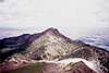
Ruby Peak is the prominent summit almost due south of the town of Enterprise. It is not a challenging climb, but is rarely ascended outside of hunting season.
The upper slopes of the mountain are primarily basalt underlain by granite.
 |  |
Getting There
Getting to the trailhead is a challenge compared to getting to the summit.
Barstad's book has excellent directions, but several road names have changed. I have checked the distances myself and provide them below.
At the south end of the town of Enterprise Hurricane Creek Road goes straight where Hwy 82 turns left 90 degrees. Stay straight onto Hurricane Creek Road. Take the second right on Fish Hatchery Road. Go 1.2 miles on Fish Hatchery Road and turn left onto another road which seems to have a couple of names, so pay attention to distances. Take this road for 1.7 miles. At this point the paved road you're on takes a sharp right and a gravel road goes straight. Go straight on the gravel road. Stay on the gravel road for 1.8 miles and turn left on a gravel/dirt road. (The surface may be variable because it appears property owners are responsible for maintenance. I've been on this road in 2002 and 2003; and in 2003 the initial section was in much better condition than the previous year.) Follow this road 2.1 miles to a wide spot in which 2-3 cars could be parked. You're at the trailhead.
Note this last road, called Lime Quarry Road according to maps but I saw no street signs, is not one you will want to admit to your wife you took the family car up. High clearance is recommended and 4-WD is probably a necessity if it's wet. I drove this road in a Land Cruiser and crept up and down.
 |
Red Tape
You are parked in the National Forest, so a Northwest Forest Pass is required.
You start out in National Forest, then cross into the Eagle Cap Wilderness, the go out of the Wilderness on the upper slopes. A free wilderness permit is probably required if you camp on Silver Creek, but none are available as they are at other trailheads.
When To Climb
This climb is possible year-around. Locals have told me it's a busy area during hunting season.
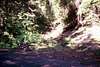
This is a class 2 scramble. The trail portions follow Silver Creek Ditch and/or Silver Creek, depending on which ridge you ascend, so water is plentiful.
Camping
There are meadows all the way up Silver Creek with good primitive camping possibilites. There is not good camping at the trailhead or along the trail prior to the end of Silver Creek Ditch.
There are commercial campgrounds in Joseph.
Mountain Conditions
Additional information is available at Wallowa-Whitman National Forest
Height Ranking
Ruby Peak is listed as the 40th highest mountain in Oregon by Oregon's 100 Highest Peaks