
-
 113293 Hits
-
 92.92% Score
-
 41 Votes
|
|
Mountain/Rock |
|---|---|
|
|
36.93190°N / 102.9977°W |
|
|
Cimarron |
|
|
4975 ft / 1516 m |
|
|
Overview

The highest point in Oklahoma, Black Mesa, is 1,517 m (4,975 ft) above sea-level. This area is found in the extreme western part of the state's Panhandle, and is named for the dark pumice found all over the terrain. When this area was volcanically active, lava flows, cones and domes all worked in concert to shape the landscape that can be seen today. The main draw to the area is nearby Capulin Volcano in New Mexico, which spewed forth the lava flow that created Black Mesa. Igneous rocks, the type associated with all volcanism, are much more durable and erosion-resistant than the sedimentary rocks that they overlay; thus, the borders of the lava flow form a sort of cap that prevents the rock beneath them from being eroded as quickly as the rock immediately next to the flow's boundary. This type of process is what formed Black Mesa, OK, as well as many of the features in northeast New Mexico. Black Mesa's true summit does not lie in Oklahoma, as the slope gradually in elevation across New Mexico and Colorado. The USGS lists the highest point in Colorado at an elevation of 5,715', however, this point flows directly up to the Mesa de Maya also in Colorado. The highest point of Mesa de Maya, also known as the Corona, is 6,840+' in Las Animas County, Colorado.
 |  |  |  |
Getting There
From Kenton, OK: - Go E on CR 325 for 0.5 miles to a road leading N. - Turn N (L) and meander 5.0 miles until reaching the Nature Conservancy preserve parking lot (on L).
 |  |  |  |
Red Tape
The route to the "summit" of Black Mesa is owned by the Nature Conservancy, which has purchased much of the land in the area and is maintaining its natural beauty for the coming generations. The "summit" itself is a small bastion of Black Mesa State Park; the vast majority of this park is located several miles south. Currently, there are no access restrictions on the trail leading up to the summit.
 |  |  |
When To Climb
Any time of year
Miscellaneous Info
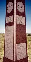
The tall granite column standing on Oklahoma's highest point contains some interesting information including the fact that Cimarron County, OK is the only county in the U.S.A to touch 4 different states (Texas, New Mexico, Colorado, & Kansas). It also shows the distance from the highpoint to each state boundary.
 |  |
External Links
The Nature Conservancy - Black Mesa Nature Preserve
Alpinist - Sep 17, 2008 5:17 pm - Voted 10/10
Bad linksFYI - Two external links at the bottom of the page appear to be permanently out of commission: America's Roof website and Ryan Cragun's website.
wblume - Oct 31, 2009 4:43 pm - Hasn't voted
Re: Bad linksryan craguns website appears to be moved to http://www.ryananddebi.com/2003/07/19/ok-black-mesa/
txmountaineer - Nov 2, 2009 12:02 pm - Hasn't voted
Re: Bad linksThanks for the comments, both of you! these links were added by another user back in the SP, ver 1 days, so I've removed all the personal website links and replaced them with the official link to the Nature Conservancy. Best Regards!
MalibuBill - Oct 22, 2014 6:35 pm - Hasn't voted
Black Mesa B&B and hikeWe located what we hoped would be and turned out to be a very nice place to stay, Black Mesa B&B. It is right on the road north from 325, maybe 2 miles north and about 2 miles from the trailhead, which is quite well marked. The owners, Monty and Vikki Roberts are personable and eager to please and do furnish, as advertised, a country breakfast. They also permitted us to use the kitchen in their 100 year old ranch house to prepare our dinners. We arrived late afternoon on October 14, 2014, hiked the peak on October 15 and spent that night. Accommodations were comfortable and adequate with the hospitality of the hosts more than making up for any shortcomings. We stayed in the downstairs room in the main house. There is a new cabin on the property that costs a little more also. The guests in it were quite content also. We would return. The hike itself was fun on a gorgeous if slightly too warm (84 degrees) day. Since a year ago winter arrived in early October in the Plains we were pleased.
HasseFamily - Apr 9, 2015 10:22 pm - Hasn't voted
Re: Black Mesa B&B and hikeWe would also highly recommend the Black Mesa B&B. While we didn't get the opportunity to stay there, Vicki did us a huge favor out of the goodness of her heart. Good people. We spotted a herd of Bighorn sheep near their property. We had perfect temperatures for our hike to the top of Black Mesa. It was a great day.
Bark Eater - Oct 21, 2015 1:20 pm - Hasn't voted
Re: Black Mesa B&B and hike+1 recommendation for the Black Mesa B&B. Comfortable, quiet, very accommodating hosts. We stayed in the "Sunrise Cabin".
HasseFamily - Apr 9, 2015 10:36 pm - Hasn't voted
Directions from the NorthWe approached the area from the north in Colorado (southbound 385). At Campo, we travelled west on CR J and then south on CR 13. Both were dirt roads and probably didn't save us much time over taking 385 all the way to 325, but the scenery was very interesting--including a sign proclaiming a ranch "Poverty Acres." CR 13 eventually intersects with 325. We travelled west on 325 and turned north on NS 3.8 which took us to the trailhead.
6sniders - Jan 23, 2017 11:07 pm - Voted 5/10
Trail info..?We are coming from NC in May and renting a RV to do 8 High Point states. So we are trying to calculate each HP its time from parking lot/trailhead to summit, parking area, road condition coming in etc. Could you please post info about the parking area, the one way distance to the summit, and are there trail options to take, is the road to the trailhead paved?...thank you.
6sniders - Jan 23, 2017 11:16 pm - Voted 5/10
found infofound info on http://www.bestoklahomatrails.com/blackmesatrail.html
HappyHikerAK - May 27, 2018 3:24 pm - Hasn't voted
Closed Due to FiresJust a heads up that the Black Mesa trail is closed right now due to a fire on top of it, along with little brush fires down below it. We did stop in at the Black Mesa B&B and chatted with the owners for a bit, and they are super nice people! We’ll definitely be staying there when we come back to bag this high point!
John G - Jun 14, 2018 12:24 pm - Hasn't voted
Alt shorter approachIn May of 2018, we approached from the east, driving in on the dirt road that leads to the Mesa Valley Guest House about .42km, and then turning west on a slightly worse dirt road (the road was open, decent, and with some care passable in a minivan) approx 1.4km to a barbed wire cattle gate (which was closed but not locked). Gate is here: http://wikimapia.org/#lang=en&lat=36.928436&lon=-102.981151&z=17&m=b&show=/38227764/Barbed-Wire-Gate The road to the west past the gate deteriorated a bit and was impassable with our minivan. (If you travel past the gate, please leave the gate as you found it.) The 1.7km hike from the gate west up to the top of Black Mesa was fairly easy, but I might suggest boots, as there are small cactus & rattlesnakes eking out a living in the low grass.
John G - Feb 11, 2021 11:12 pm - Hasn't voted
Re: Alt shorter approachSomeone inquired about climbing the vertical part of the mesa. The 'vertical' part of the mesa was far from vertical, most of it was a 20%-25% easily walked grade. We did encounter a small section of 'vertical' rock which we could have climbed, but we didn't bother – every few feet there were broken gaps in the 'cliff' we just passed thru. We returned a slightly different route, heading out to the point at 36°55'43.6"N 102°59'40.6"W (36.928764, -102.994613) to take in the view. From there, we dropped over the lip of the mesa, having no trouble finding many gaps in the broken rock to descend thru.