
-
 16294 Hits
-
 80.49% Score
-
 12 Votes
|
|
Mountain/Rock |
|---|---|
|
|
45.58630°N / 121.8111°W |
|
|
4674 ft / 1425 m |
|
|
Overview
Chinidere was the last of the Wasco Indian chiefs holding power prior to the arrival of Europeans and this mountain is named in his memory. His son, Tomlike, is remembered by his namesake mountain a few miles to the NNE.
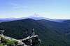
Situated in the heart of the Cascades, in the Columbia Wilderness, adjacent to the Columbia Gorge National Scenic Area, the summit of Chinidere affords commanding views in all directions, especially of Mt. Hood, but also, Jefferson, St. Helens, Rainier and Adams. Nearly all of the popular highpoints in this area can be spotted, such as Mt. Defiance, Larch Mt., and many, many more. Wahtum Lake sparkles below to the SE and excellent views of the Benson Plateau and the Eagle Creek Canyon are to the north.
This can be an easy 3.4 mile round trip walk-up from the Wahtum Lake trailhead or you can do the whole thing from basically sea level using the Herman Creek Trail, the Eagle Creek Trail or the PCT making it a 22 to 28 mile trail run/hike loop depending on your choice of routes. The summit rocks might afford some interesting rock climbing but they are a bit unstable in places.
 |  |  |  |
Getting There
From I-84 at Hood River go south though the upper part of town on 12th then 13th St. eventually taking Tucker road which turns into the Dee Hwy. At Dee, cross the railroad tracks passing by the abandoned sawmill, cross the river and turn left at Lost Lake Road. 4 ¾ miles up this road take the right fork marked "Wahtum Lake". After another 4.4 miles take the right fork again. At 14.5 miles from Dee, park in the trailhead parking lot to the right. The road is paved in it's entirety but narrow with turnouts past the second fork.
 |  |  |
Red Tape
The trail is entirely within the Columbia Wilderness so the usual rules apply. Trail park passes are required at the trailhead, and since there is no pass kiosk there, suggest you acquire the needed permit before you head up the mountain. Should you find yourself up there with no pass, another option would be to park a quarter mile or so up the road where no passes are required.
When To Climb
The road will be closed by snow from about November until about May, depending on the year. The "long" way, via the PCT, the Herman Creek trail or the Eagle Creek trail can be done any time of the year but it's a minimum of 22 miles round trip and snow shoes may be needed most of the winter and well into the spring.
Camping
Lots of camping spots along or near the trail. No reservations or fees required.
Mountain Conditions
The trailhead is at about the same elevation as Government Camp so here is the NOAA link for that: Weather
For the nearest town below the mountain, here is the link for Hood River: Weather