Overview
At 12,716 feet of elevation,
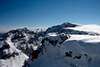
Ouzel Peak is only the 35th named summit in
Rocky Mountain National Park. Considering that the approach from the closest trailhead is over 8 miles, it shouldn't surprise that this summit along the Continental Divide sees few visitors each year. Ouzel Peak, however, cuts a very elegant figure against the sky when seen from the east, and offers to the determined hiker
great views from its top. The two miles of the Continental Divide that form the western border of Wild Basin between Isolation Peak to the north of Ouzel Peak and Ogallala Peak to its south allow one to make a very long day even longer by combining a visit to Ouzel Peak with one to either (or both) of its neighbors. The difficulties along this stretch of the Divide never exceed class 2.
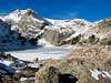
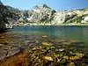
There are several ways to attain the watershed from southern Wild Basin. To reach it to the south of Ouzel Peak, one can climb to
Cony Pass and from there to the Divide (class 4), or ascend one of the two steep couloirs known as Cony Express. The southern one is approached from
Cony Lake, while the northern one from
Junco Lake. To reach the Divide to the north of Ouzel Peak, the easiest approach is to climb from
Pipit Lake directly to the lowest point of the ridge that connects Ouzel Peak to
Isolation Peak. Reaching the Continental Divide from the west requires a very long hike. Given the ban on camping in Paradise Park, not many will feel up to it. Finally, there are the direct routes to Ouzel's summit, which, besides the
northeast ridge described here, include the
east ridge and the
north slopes. In summer conditions, the former should be class 3 and the latter are class 2.
Getting There
The two most common approaches to Ouzel Peak are from the Wild Basin Ranger Station trailhead and from the Finch Lake trailhead, both located in Wild Basin, Rocky Mountain National Park. The
Wild Basin entrance to the Park is located on Colorado Highway 7, between Allenspark to the south and Meeker Park to the north. After turning west from Colorado 7, go for less than half a mile until you turn right at a sign indicating the Wild Basin entrance station. The Wild Basin Ranger Station trailhead (8480 ft) is located at the end of the dirt road that starts at the entrance station. The Finch Lake trailhead (8460 ft) is along the same dirt road, about a quarter of a mile from its end. The trailhead is on the left (south) side of the road, indicated by a sign that is well visible. If you reach the bridge on the St. Vrain Creek you have gone too far. The dirt road is passable by passenger cars.
Red Tape
No permits are required for day hikes and climbs in Rocky Mountain National Park. There is no parking fee. The entrance pass to the park is $20 per car and is valid for 7 days. The fee, however, is not collected before 6:30 AM. All park visitors should follow the
Leave No Trace policy.
When To Climb
Spring to Fall. During the summer months, an early start is strongly advised to minimize the danger of lightning. (More people are killed in the U.S. each year by lightning than by hurricanes.) An ascent during the winter would be substantially more challenging than one during the summer: One should expect ice, strong winds, sub-zero (Fahrenheit) temperatures, and frequent storms. Spring and Fall present the most variability. Summer conditions may prevail until October, or may be already gone by late August.
Camping
There are several camping sites within the park and specifically in Wild Basin. It is usually easier to get permits for Wild Basin than for the rest of the park. Details on locations, facilities, reservations, and fees can be found at the
camping page of RMNP.
Bivy information can also be found on the park's site.
Mountain Conditions
The park's
contact information page lists useful numbers. Two
webcams, one pointed at Longs Peak and the other at a stretch of the Continental Divide, allow one to get an idea of the conditions not far from Ouzel Peak. Detailed forecasts are provided by
NOAA.
Never forget that the weather may change very rapidly in the high country. The temperature may drop by 50°F or more in a couple of hours. Those who have been caught out by such sudden changes without proper equipment and preparation have not always survived.