
-
 36831 Hits
-
 87.31% Score
-
 24 Votes
|
|
Mountain/Rock |
|---|---|
|
|
39.95040°N / 77.9367°W |
|
|
2458 ft / 749 m |
|
|
Overview


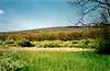
The County highpoint for Franklin and Fulton Counties in South-Central Pennsylvania, the actual summit of this long, linear Pennsylvania mountain is called Big Mountain. Tuscarora Mountain is a NE-SW ridge which rises gently from near the Mason-Dixon line and extends all the way northeast to the Juniata River, opposite Millerstown. It forms the E/SE boundaries for Fulton, Huntingdon and Juniata Counties, as well as the West boundary of Franklin County and NW boundary of Percy County.
History:
Tuscarora Mountain was named for the Tuscarora Indians, a tribe adopted by the Iroquois Nation and allowed to migrate to this region around 1714. The mountain runs through the present-day state forests of Tuscarora (named after the mountain) and Buchanan, named after President James Buchanan, who was born next to Tuscarora Mountain in 1791. An 18.5-acre park , Buchanan's Birthplace State Park, complete with a monument, is nestled back in the woods above the town of Cove Gap, next to the Tuscarora Mountain, to commemorate this president's birthplace.
The Tuscarora Trail:
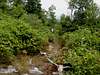
Tuscarora Mountain boasts numerous miles of the Tuscarora Trail, a 252-mile spur off the Appalachian Trail running through four states (VA, WV, MD, PA), which is maintained by the Potomac Appalachian Trail Club (PATC). Once anticipated to be a section of the Appalachian Trail, the trail fell into neglect after the A.T. was instead maintained to the east. The Tuscarora Trail was nearly abandoned until the PATC and other volunteers took up trail maintenance in the late 1990s. This trail offers a lot of nice, easy walking, but surprisingly rocky sections make for some fun scrambling along the Tuscarora Mountain ridge.
Nearby Destinations:
Cowans Gap State Park
Buchanan's Birthplace State Park
 |  |  |  |  |
Getting There
This is an easy destination. Several roads cross Tuscarora Mountain's ridge. The Pennsylvania Turnpike actually goes through the mountain at the Tuscarora Tunnel. To get to the actual summit, Big Mountain, take Rt. 30 to the top of the mountain ridge, "Tuscarora Summit," and follow a dirt road north from there to the Big Mountain Lookout. This is the summit. There are a couple hiking trails to the summit, including the Tuscarora Trail, a spur of the A.T., which I will outline more thoroughly in the future.From Cowans Gap:
The park is between Chambersburg and McConnellsburg. To reach the park from the west; take Exit 180, Fort Littleton, of I-76, then US 522 north to Burnt Cabins and follow signs to the park. From the east; take Exit 189, Willow Hill, of I-76, then PA 75 south to Richmond Furnace and follow signs. From US 30; take PA 75 north at Fort Loudon to Richmond Furnace and follow signs.
To get to the summit from Cowans Gap State Park in Fulton County:
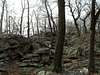
"Tuscarora Trail is a spur trail to the Appalachian Trail. The more popular section to walk is a 1.5-mile section beginning across Aughwick Road from Parking Lot #3, climbing along Tuscarora Mountain to the junction with Geyer Trail. Once at the junction with Geyer Trail, you can return to the day use area, retracing your walk from Parking Lot #3, or follow Geyer Trail to Cameron Trail then to Plessinger Trail returning to the day use area, or take the Tuscarora Trail another 2.4 miles south to the top of Big Mountain and a spectacular overlook of the Path Valley and Franklin County. From the Big Mountain Overlook, you will have a 3.9-mile return hike back to the park. The Cowans Gap section of the trail is renowned for its unusual rock outcroppings and rock fields."
(From Mountain Travel Guide)
Red Tape & Camping
Considering how long this mountain is, this section is a bit complicated. The actual summit and much of the mountain rests on state forest land, which allows backpackers to camp at no cost. However, some of the land on either side of the mountain is private ground or State Game Lands. Obviously you need permission to trespass on the private land, and camping is not allowed at all on the State Game Lands. Access is free.Flora and Fauna
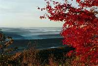
Fall colors in the leaves are spectacular, from the brilliant oranges of maples to yellows and reds of birch and oaks and tulip poplars... Lower to the ground you will often find huckleberies, mountain laurel, greenbrier, and many others.
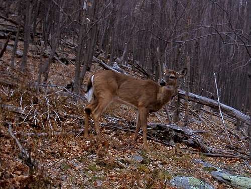
In any case, if you enjoy wildlife photography or hunting or fishing, you have come to the right place!
 |  |  |
When To Climb
Year-round, but be prepared for the weather. It can get surprisingly windy at the top of this ridge. Also, nasty snow drifts in the winter can make for some slippery and potentially dangerous conditions along the jagged rocky out-croppings at the ridge-top.Mountain Conditions
For current weather and 10-day forecast for the McConnellsburg area, Click Here.Note: Conditions are often windier and might be cooler on top of the mountain. Go prepared!
(Forecast provided by weather.com)
External Links
- PA Dept of Conservation and Natural Resources
Some information concerning the local state forests.
- The Tuscarora Trail
Information on the Tuscarora Trail.