
|
|
Mountain/Rock |
|---|---|
|
|
45.49890°N / 121.8586°W |
|
|
Multonomah |
|
|
4751 ft / 1448 m |
|
|
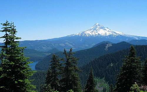
Mount Hood as seen from the summit of Buck Peak
Overview
Interested in a forested summit that is just 1/4th mile off of the Pacific Crest Trail that has a killer view of Mt. Hood(above) for its reward? If you are, then Buck Peak (below) is the one you want.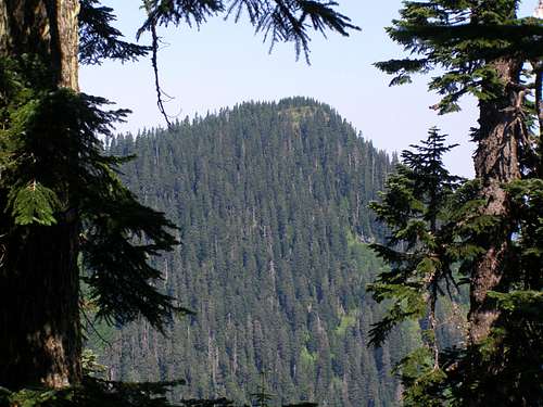
Buck Peak as seen from the PCT
Some 13 air miles away from the north face of Mt. Hood, lies the little known Buck Peak, the highest point in Multnomah county.
Standing at 4751 feet, this is not a lofty peak nor a challenging one but what makes it worthwhile is the view and the fact that it is the Multonomah county high point. Factor in the fact that Multnomah county, with almost 700,000 people is the most populous county in the state of Oregon (Portland), and you have a peak that is almost totally unknown by this very same population. Few Portander's have ever heard or seen Buck Peak and only a handful will ever visit it. That is one of the reasons why it takes a person from Washington State to tout it as a place that is worth a visit. (just kidding you Portland people)
HOW BUCK PEAK GOT ITS NAME:
Thanks to SP member cmc56789 who found in the resource "Oregon Geographic Names", this peak was named in 1906 by R.S. Shelley of the Forest Service after a large Buck he found sunning himself on the summit .
Getting There
You can access this peak from three different directions. From the north off of I-84 via the Eagle Creek Trail or Cascade Locks via the Pacific Crest Trailhead. Approaching from this direction will add many trail miles to your effort.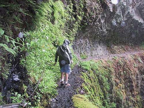
Eagle Creek Gorge trail
1A
Eagle Creek TH: Access:From Portland as you head eastbound on I-84, take exit # 41to get to the Eagle Creek exit which is only available eastbound. If you are coming from the opposite direction (westbound) exit at Bonneville Dam and backtrack on I-84 to exit # 41. As you are heading eastbound, you pass through a tunnel. The exit #41 is just after this tunnel so be aware of this fact. After exiting, stay to the right and go through the parking area to the TH which is about three tenths of a mile. A left near the parking area will take you to the Eagle Creek Campground . See Eagle Creek-PCT Route description.
1B
From Portland to Cascade Locks:
Getting there: Head east on I- 84 and take Exit 44 at Cascade Locks. Follow the off-ramp toward town and just as you pass under the steel girders of the Bridge of the Gods, turn right and park along the road before the toll booth (the parking lot for hikers may be closed). The trail starts to the south, across the road. (trail description not finished at this time)
---------------------------------------------------------------------------------------------------------
2.
From the south at Lolo Pass where the Pacific Crest Trail is intersected by the Lolo Pass Road, coming up from Zig Zag Oregon. Here's the road description: This was the way I went.
Accessible from Portland via highway 26 which takes the traveler through Sandy, Rhododendrom and Zig Zag (don't you love the names). The turn off to Lolo pass is right in the center of town, just before the Ranger Station. If you pass the ranger station, you've gone too far. Watch for E. Lolo Pass Road which is marked. This is the road you want. Set the odometer and head north on this paved road, driving through woods dotted with occasional houses . The road curves here and there but at around mile 4.5 you'll start to drive along some huge power lines while gaining altitude and finally at mile 10.5 the road will crest at Lolo Pass. There is a good pullout for parking on the south side of the road along with other dirt roads breaking off here and there.
See the route posted for Lolo Pass-PCT posted under routes.
----------------------------------------------------------------------------------------------------------
3.
From the east : Read all of the following information as this approach can be confusing unless you've done your homework. The Huckleberry Mtn Trailhead is not easy to find and offers you the reward of being the shortest access to Buck Peak if you can find it. The Zig Zag Pass route is far easier to find although it is 2 to 3 miles longer. Want to save those 2-3 miles? Read on.
From Hood River, head south on SR 35. At about 5 miles, turn right on Hill Dr. which will turn south in about a mile. In another 1/4 mile turn right on Ehrck, which will become Summit Dr. This will take you to the Hood River Highway, turn left here. In several more miles, at Dee, reach the signed road to Lost Lake (forest route 13) and turn right; when the route 13 loop forks, keep right. In 5 miles, find the Wahtum Lake road (1310) on your right. This is paved to the lake. Take the gravel continuation of the road SW from the lake, staying high at forks until the left fork for Indian Mountain - keep right here. Follow the road until it is closed by a berm; this is near the SW corner of Section 21. A current Mt Hood National Forest map will be useful in following these roads.( credit for this info goes to Ken Jones)
Bob Bolton added this information "I drove to Wahtum Lake per Ken Jones' report, except that I accessed the Hood River Highway through the town of Hood River instead of using SR35. As Ken explains, the road turns to gravel right after Wahtum Lake, and according to one book it changes from FR1310 to FR660 at that point. On this road I turned right at all three forks. The third right turn was down off the ridge on a narrow spur that might cause problems for some passenger vehicles. If desired you could park at the fork and walk the road. If you drive, you can park at a campsite, maybe a quarter mile down from the junction, where the Pacific Crest Trail crosses this spur road. This is where my approach varied from Ken's report. He drove the main road until it ends with a huge berm, then hiked the road until the PCT crosses it. Last November when I was up there, I walked down that road past the berm and it wasn't much fun because the entire road had been filled with big mounds of dirt, making walking rather difficult. Also, that parking spot is higher than my starting point, making the return elevation gain greater than mine. My approach was probably a bit longer, but that seemed negligible given the flatter trail."
Adding more information to the above approach, Jeff Macey added this "To reach the trailhead, proceed as to Wahtum Lake, but stay on the Lost Lake road until it enters Lost Lake campground. The only drawback to this hike was the $6.00 fee to get in Lost Lake. Follow the main road to the organizational camp and continue to the end of pavement and go about one mile on a dirt road to the sign.
Now finally, Adam Helman had this to add "As Jeff noted, one advantage of this route to Buck Peak is the all-paved driving approach, in total about thirty miles from Hood River along Interstate 84. As I neared Lost Lake by auto I found that the Jones Creek Road was inexplicably blocked by a delapidated gate about one mile north of the desired trailhead. Parking my car, I investigated by walking past the gate and found that somebody had set up an elaborate set of tents right in-the-middle of the road, with a huge berm of sand and conifer branches blocking further progress along the road, on-foot or otherwise.
Undaunted, I drove back north, then west and south to a parking lot perhaps 100 meters from the lake shore. With daypack shouldered, I ended up walking down a footpath, for about one mile south, passing numerous shore campsites until I exited the camping area on its south end, arriving at a road junction at NAD27 UTM coordinates (593016 E, 5036937 N).
I walked the road leading southwest about one thousand feet to find the Huckleberry Mountain Trail trailhead on my right (north) side at NAD27 UTM coordinates (592752 E, 5036729 N).
Bob Burd's route:
Bob Burd found a route that cuts the mileage down but requires some steep cross country and bushwhacking. See his trip report HERE.
For a lot of additional information, peakbagger.com has a page filled with links to trip reports that you might find worth checking out. Many have filed their GPS tracks as well. As of July of 2015, 49 people had listed successful or unsuccessfuls summit visits. Check it out here.
Red Tape

Near the summit of Buck Peak
Parking at any of the trailheads requires a Northwest Forest Pass. $5 (this may have changed since this was posted back in 2003) so
check it out at a local ranger station. There is one in Zig Zag or REI stores. Plan ahead.
Also, leave nothing of value visible in your vehicle as car breakins have been reported in the Eagle Creek TH area.
Be aware that the land on the west side of the Pacific Crest Trail is posted for No Trespassing by the City of Portland since it contains Portlands water supply. These signs are posted continuously along the trail if you come via Zig Zag Pass.
When To Climb

This is a trail route and best left to the late spring when the snow melts off the Pacific Crest trail. This should be doable until late fall when snow makes travel difficult
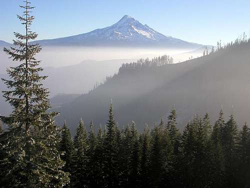
Mt. Hood
Camping
A small campsite is available very near the summit area of Buck Peak. Unless there is snow nearby, you'll have to pack all your water.You can camp at many locations in this area. At Zig Zag Pass, I noticed a spot on the south side of the road, just off of the Pacific Crest Trail where people had camped. Zig Zag Oregon has a campground called Little Crater Lake that has car camping, trailer camping and tent camping possibilities.
Lost Lake campground as mentioned in the "getting there" section, is a worthwhile overnight destination for those who want to camp or fish. The link has a great story attached to it.
You could camp at the Eagle Creek campground is you access Buck Peak via that route (very long) but I don't recommend this campground as it is just above the railroad tracks and from personal experience I can attest that you don't get a lot of sleep. One interesting fact about this campground is to be found here, please read the significance of the historical aspect. Here's more info on Eagle Creek campground however as the price is right, just be sure to take ear plugs.
Eagle Creek Campground
c/o Columbia Gorge Ranger District
31520 SE Woodard Road
Troutdale, OR 97060
Operated By: Mount Hood National Forest
Information: (541) 386-2333
Open: Mid-May to October
Individual sites: 17
Each site has: Picnic table, fire pit with grill
Site assignment: First come, first served; by reservation for groups
Registration: Self-registration on site
Facilities: Bathhouse with toilets and piped water; boat launch nearby
Parking: At individual sites
Fee: $8 per night (may be more in 2015)
Elevation: Sea level
Restrictions:
Pets— On leash
Fires— In fire pits only
Alcoholic beverages— Permitted
Vehicles— RVs and trailers up to 22 feet
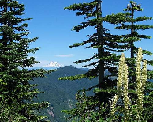
Mt. Adams and some beargrass
Mountain Conditions
The Camp Road Cam is located at about 4000 feet. Conditions viewed on this cam will provide an indicator of what conditions might be on Buck Peak. If you see snow here, forget Buck Peak until you see no snow.Weather reports for Government Camp can be found HERE
Multnomah County History
Multnomah County was created on December 22, 1854. It was the thirteenth county created in Oregon Territory. The land was taken from the eastern portion of Washington County and the northern part of Clackamas County. The borders have remained relatively unchanged to the present.Multnomah County was created when the people living in Portland found it difficult to travel to Hillsboro to conduct business at the county seat of Washington County. They also thought that they were paying too much in taxes to support the farmers in the rural areas surrounding Portland. In 1854, Portland businessmen petitioned the Territorial Legislature for a new county and Multnomah County was created at the subsequent session. The county was named after the Multnomah Indians who were part of the Chinookan tribe that lived on the eastern tip of what is now Sauvie Island in the Columbia River. The City of Portland was chartered in 1851 and made the county seat in 1854. The Multnomah County Commissioners met for the first time on January 17, 1855.
Multnomah County is the smallest county in Oregon, with only 465 square miles. It is bounded by Columbia County and the Columbia River on the north, Washington County on the west, Clackamas County on the south, and Hood River County on the east.
The principle industries of Multnomah County are manufacturing, transportation, wholesale and retail trade, and tourism. Tourism attractions in Multnomah County include the Oregon Museum of Science and Industry, Washington Park and Zoo, Oregon Historical Center, Portland Art Museum, Rose Test Gardens, and Japanese Gardens in Portland, and Multnomah Falls in the Columbia River Gorge. The Port of Portland, established in 1891, ranks third in total waterborne commerce on the West Coast. Portland is one of the five largest auto import ports in the nation and is the West Coast's leading exporter of grain and lumber. Portland International Airport is one of the fastest growing airports on the West Coast, serving as a Northwest regional hub and gateway to the Pacific Rim.
The population of Multnomah County has steadily increased since 1860. The 2000 county population of 660,486 represented an increase of 13.12% over 1990. Portland is the county's largest city with a population of well over 500,000. So, it is interesting that most people in Portland would have no clue about the peak that is the highest point in the whole county.
The Pacific Crest Trail
Running from the Mexican to Canadian border, this trail is one of those huge challenges that only a few dozen complete in one effort each year. An amazing achievement for sure but the key thing here is that Buck Peak is just off of this trail and to reach the top of Buck Peak means sharing the PCT for a few miles.Over 2600 miles in length and running through the states of California, Oregon and Washington, it is filled with special places that thru hikers and section hikers remember fondly. The Sierra-Nevada mountains, the Marble and Desolation Wilderness areas in California, and in Oregon, it is the Eagle Creek portion, an alternate section of the PCT that is looked forward and unfortunately is all too brief. It does provide a route to Buck Peak as mentioned above.