
|
|
Mountain/Rock |
|---|---|
|
|
35.29970°N / 115.5631°W |
|
|
5755 ft / 1754 m |
|
|
Overview
"Congratulations. You have reached obscurity." - Teutonia Peak summit register entryIndeed. Teutonia Peak is no major mountaineering objective. Rather, it is an excellent logistical base for a variety of worthwhile endeavors. The area is contained within Mojave National Preserve and boasts a number of cool things and plenty of interesting trivia. Let me lay some of it out here...
In the northern part of the preserve, including the area surrounding Teutonia Peak, is one of the largest and densest Joshua Tree forests in the world. The norther portion of the preserve also contains Clark Mountain, whose summit reportedly offers outstanding views of the surrounding area. Near the preserve's eastern border are the New York Mountains, an impressive granite range of rugged peaks. Just to the north of the New York Mountains, one will find Castle Peaks, a group of crags readily visible from I-15 between Mountain Pass and Primm, Nevada which offers some interesting technical climbing. Further south in the preserve can be found some interesting caving (some commercialized, some wild) in the Providence Mountains, including Mitchell Caverns, where scenes from the film "The Doors" were filmed. The Kelso Dunes, contained within an area called the Devil's Playground, is a vast expanse of sand dunes located in the southern portion of the preserve. The Kelso Dunes are the highest dunes in California. Also located in this vicinity are a few lava tubes. Cool stuff. Additionally, the area has a rich mining history, as evidenced by a huge number of abandoned mines (stay out!) and some historical buildings (including an old train station which has been converted into a visitor's center).
In the central part of the preserve lies the sprawling mass of Cima Dome. While others disagree, some geologists say that Cima Dome is all that remains of an ancient mountain range in its last stages of decay and erosion. The huge rounded hump of Cima Dome can be clearly viewed while traveling on I-15 between Baker, California and Mountain Pass. It is there, on Cima Dome's northern slopes, that Teutonia Peak comes into the picture. Teutonia Peak is (again) believed by some to be the last few granite crags still poking out of the old, eroded and vanishing range - a last few protuding fingers of rock not yet disappeared into the rounded and eroded dome.

Teutonia Peak itself:
Easy access to the mountain's route-laden 3 "summits" provides a good variety of scrambles and climbs on decent granite. From the summits, distant views of Telescope Peak and Charleston Peak, and closer, Clark Mountain, New York Mountain, and others greet the random desert visitor.
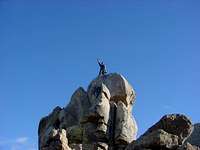
Oh yeah... The summit register, contained within an old, rusty tin can, can be found on the central "summit", which just barely scrapes by as the highest of the mountain's 3 "summits". The register dates back to 1983, with only a few dozen entries. These entries are some of the most bizarre I've yet come across - weird drawings and odd poems seem to rendezvous here, with only the occasional legible, coherent and rational entry thrown into the mix.
Getting There
From Las Vegas, take I-15 south into California. Passing Primm, Nevada, look for the Nipton Road turn-off (just before Mountain Pass) and take it. Cross over the highway and take the Nipton Road east for a few miles until you reach the signed Ivanpah Road. Turn right. Head south-ish on Ivanpah Road for a couple of miles to the signed Morning Star Mine Road. Turn right. After a few miles, you will come to a stop sign, which also serves as a junction for Morning Star Mine Road, Kelso Cima Road, and Cima Road. Hang a direct right onto Cima Road. After passing a few abandoned buildings, you will soon come to the signed dirt parking area (on the left) for Teutonia Peak. Teutonia Peak is the rather unimpressive cluster of crags (sorta mountain-ish) to the left (southwest). It can't be missed. You will be looking at the northern and very rounded slopes of Cima Dome - Teutonia Peak is the only thing on the slope that even resembles a mountain. Start here.* Alternatively, you can also continue south on I-15 past Mountain Pass and head for Baker, California. Before reaching Baker, leave the highway at the signed Cima Road exit (only a few miles past Mountain Pass). Once on Cima Road, head southeast for several miles to the signed trailhead.
The trail: It's obvious, well-traveled (not for its peak-bagging opportunities, but for its travel through the Joshua Tree forest), and impossible to get lost on. Follow the trail for less than a mile as it heads southwesterly across the desert, through the Joshua forests, and past a couple of mines to the base of Teutonia Peak.
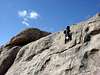
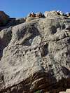
Although appearing from the trailhead as a small mountain, as you approach its flanks, you will see that Teutonia Peak is more of a collection of crags on the northern slopes of the dome. Although not immediately apparent from the trail, once the "summit" is gained, one will notice that the mountain is comprised of three somewhat distinct "summits" - a north, a central, and a south. The central is the highest. Since the routes are various and worthy, I will describe a few usable routes to the three summits, including a subsidiary crag just north of the north summit that I felt to be the best of all. Remember though, the best part of Teutonia Peak climbing is the freedom to pick any route you want - from easy class 3 to challenging class 5. (Sorry, nothing easier than that.) Roundtrip is no more than 2 1/2 miles with 700 feet of gain. It's ridiculous.
* North "summit": Continue on the trail as it winds its way up onto the north ridge of the peak. After only a mile or so from the trailhead, the trail ends at a sort of saddle. There should be a cairn prominently displayed here. Immediately to the left is the aforementioned subsidiary crag, and immediately to the right is the north "summit". Back-tracking a few feet, look for a use trail that heads southwest along the north side of the crags denoting the north summit. Follow the use trail a short distance (less than 50 feet) until it leads you left and to a kind of "cave" in the rocks. Sticking your head into the cave, you will see that the route continues up an easy class 5 chimney for maybe 30 feet. Climb up the chimney. Once at the top, squeeze out and carefully make your way across class 3 terrain to the highpoint of the north summit, which is marked with a cairn. It's that simple.
* Subsidiary crag: Okay, there are lots of subsidiary crags around Teutonia Peak, but this one is obvious and rather fun. From the saddle where the trail ends mentioned above, the subsidiary crag is the precariously balanced boulder sitting atop the somewhat sheer protrusion above and to the immediate left. Back-track a hundred feet or so on the trail and find yourself on the other side of the crag. From here, look for a path of least resistance (I'll give you a hint - it involves a couple of class 3 moves up to a narrow ledge that you must lie down on and "scooch" a short distance (5 feet) across to a weird ramp-dihedral formation that you pull yourself up onto and then climb up. Go around a couple of quick bends and look up at the remaining 15 feet of impossible rock that lead up to the highpoint. Now work your way to the left and crawl up onto a short (10 feet) but narrow (3 inches) and fairly exposed (100 feet) fin of rock that juts out below the highest (summit) boulder above you. At the end of the fin, stand up on the 3 inches of exposed rock fin and you will see that your head should be just about eye level with the top of the summit boulder. Look for handholds and hoist yourself up to the top. Easier than it sounds, but not for the fearful of exposure, I hope my directions are clear. If not, just dig around for your own route - they are plentiful and varied on all of the routes around Teutonia Peak.
* Central "summit": From the aforementioned saddle between the north summit and the subsidiary crag, drop down to the east and head cross country across, over and around boulders and then brushy terrain. Follow the crags to your right and look for a prominent notch between two obvious blocky crags ahead. There should be a cairn marking the bottom of a brushy, bouldery ramp leading up to the notch. Once the notch is gained, negotiate class 3 boulders and then an easy class 4 ramp section up and to the left until you see a very easy class 2 ramp heading to the right toward an obvious crack blocking further progress. Step or jump across the crack to a nearby boulder, then work your way upward over class 3 terrain toward the summit. The summit is marked with a cairn. It is here that you will find the summit register.
* South "summit": From the top of the aforementioned notch, follow easy class 3 terrain to the east/southeast and to the summit cairn. Easy.
Although I didn't get a chance to check it out, there's good potential for a nice traverse from the north summit to the central summit. Check it out!
 |  |  |  |
Red Tape
No permits, passes or fees are required. The area is open year-round.When To Climb
Teutonia Peak can be explored year round. Obviously, like other Mojave Desert regions, it can be brutally hot in the summer.Camping
I'm not familiar with any developed campgrounds in Mojave National Preserve, but that doesn't mean they don't exist. To my knowledge, backcountry camping is allowed permit-free. Contact the National Park Service if you have specific questions.MoapaPk also adds: "There is a nice primitive camping area east from the main Teutonia parking lot. If you drive a bit south of the Teutonia parking, then cut a sharp left and drive ~NE, you can camp right by the rocky crags."
Mountain Conditions
Expect hot and dry in the summer and cold and dry in the winter.You could always check this weather link too.
Summit Portraits
Bob Burd - Nov 27, 2012 10:57 pm - Voted 10/10
Traverse"Although I didn't get a chance to check it out, there's good potential for a nice traverse from the north summit to the central summit. Check it out!" I gave this a shot, but got stopped at a 20-foot dropoff along the way, about midway. Definitely class 5.too-hard-for-me. Ended up dropping down the east side, but good, fun scrambling nonetheless.
gimpilator - Dec 27, 2017 11:34 pm - Hasn't voted
Chimney OptionFrom the notch between the south and main summit, there is an obvious chimney. It's to the right of the slabs everyone else describes and begins above the highest point in the notch. It looked easy, so I tried it. Zero exposure and it took me right to the top where the register is. Felt like class 3, but that is always debatable.