
|
|
Mountain/Rock |
|---|---|
|
|
40.96930°N / 75.1113°W |
|
|
Warren |
|
|
Hiking, Trad Climbing, Toprope, Ice Climbing, Scrambling |
|
|
Spring, Summer, Fall, Winter |
|
|
1549 ft / 472 m |
|
|
Overview
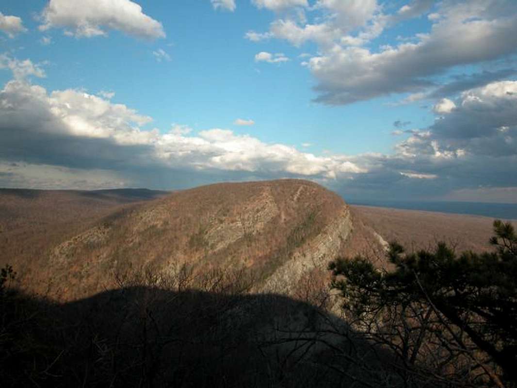

Mt. Tammany makes up the New Jersey side of the Delaware Water Gap. It is a very popular mountain for people from the NY, NJ, and PA area. Also the Appalachian Trail runs in the valley next to it so during the summer months you can meet a through hiker or two on almost everyday, I usually do when ever I am there. There are 3 trails to the summit: The Red Dot Trail, Blue Dot Trail, and The Mt. Tammany Fire Road. Besides trails there are many climbing routes on the cliffs that are on the south and east faces making Mt. Tammany a very popular mountain for climbers. Here is some info from www.rockclimbing.com on Mt. Tammany There are also some good scrambles to the top on the east side. It is the closest thing to a real mountain in NJ that I have done and I live in NJ.
Also check out the Mt. Minsi Page. for info on the P.A. side of the "Gap".
 |
 |
 |
 |
 |
History
Tammany refers to Chief Tamenend.
1683 (June 23): William Penn and Delaware Chief Tamenend signed a peace treaty in Shackamoxon, Pennsylvania. Tamenend renown for his honor, was also called Tammany. (Tammany societies were named in his honor.) The treaty gave William Penn a large portion of land. Thank You Google.
Whats near Mt. Tammany.
Natural features:
Sunfish Pond - High on top of the Kittatinny Ridge is a blue lake, Sunfish Pond, a relic of the Wisconsin Glacier (which gouged out a hollow that later filled with water) around 18,000 years ago.
History:
In 1870 Sunfish Pond was described as "a sheet of pure transparent water . . . strangely and unaccountably situated on the very Summit of the mountain." (quoted in Pepper 1965:158)
1903 -- millionaire businessman Charles C. Worthington, president of the Worthington Pump Corporation, acquires 8,000 acres on both sides of the river in the Delaware Valley. He erected a small mansion (called Buckwood Lodge) on a hillside half way between the river and Sunfish Pond (which supplied the water for the mansion). At that time, he called the pond: Buckwood Lake.
Worthington used the state forest area as a deer preserve for hunting.
Source
Dunnfield Creek- Dunnfield Creek is a natural trout stream with deep ravines. The Dunnfield Creek Trail can be combined with the Appalachian Trail for a nice loop.
Food:
New Jersey- Take 80 East to Columbia, New Jersey( exit #4) their is a bunch of fast food places right off the interstate that includes: MacDonalds, Taco Bell and Pizza Hut.
P.A.- Take 80 West and exit at the first exit and follow signs for the town of Water Gap, PA. their are a few resturants in the town.
Supplies / Gear:
PA- The nearest outfitter is the Pack Shack in the town of Water Gap. To get to it take the first exit in P.A. and follow the road into town it is on your right.
New Jersey- The nearest outfitter in NJ that I know about is Ramsey Outdoor Store In Ledgewood NJ, about 30 miles away on 80 East.
 |
 |
 |
 |
Getting There
It is the easiest mountain to get to, i think, in the world. It is right next to I-80. It is good for accibility but bad for the noise, you can hear the 18-wheelers all the time.
From I-80 east get off on the first Exit in NJ and park at the Infromation center on your Right and go hiking.
From I-80 west get off at the second to last exit in NJ and park. the trails start from the end of the parking lot.
Camping
You can camp at The Worthington State Forest , not far, for a fee, or at backpacker site #2 along the Appalachain Trail before Sunfish Pond (North Bound) The Backpacker site has no water. Stay is limited to one night. Group size is limited to 10 people. It is a tent site and no ground fires are allowed. The Rangers do give out tickets, $150 and manadatroy court apperence tickets.
Red Tape
Recreation area boundaries are marked by white metal markers with green lettering. The Appalachian Trail is marked with white blazes. Side trails to water, scenic viewpoints, or shelters are marked in blue or red blazes.
Appalachian Trail Governing Regulations
Carry out all trash.
Pets must be on a 6-foot leash at all times.
Horseback riding and bicycle riding are prohibited on the Appalachian Trail within Delaware Water Gap National Recreation Area.
All types of motorized vehicles are prohibited on the Appalachian Trail, except authorized emergency vehicles.
Cutting, defacing, or removing any natural feature is prohibited.
Self-contained stoves are permitted; ground fires are prohibited. Charcoal stove and grills are prohibited.
Camping is restricted to through-hikers who are hiking for two or more consecutive days.
Camping is limited to one night per campsite.
Camping is limited to ten persons per campsite.
Hikers MUST CAMP within 100 feet of the Appalachian Trail.
Hikers MAY NOT CAMP within 1/2-mile of an established roadway
Hikers MAY NOT CAMP within 200 feet of another camping party
When To Climb
Can be climed all year. Depending on how bad a winter ice climbing is possible.
Delaware Water Gap Weather Info
Weather for Delaware Gap, P.A.Mountain Conditions
Summit Pics
 |
 |
External Links
- http://www.nps.gov/dewa/index.htm
Delaware Water Gap's web site - Red Dot Trail Story
An interesting story of why everyone need to folow "Light is Right" Ethos - The New York-New Jersey Trail Conference
The offical website of the The New York-New Jersey Trail Conference - www.rockclimbing.com
RC info for Mt. Tammany