
-
 24589 Hits
-
 83.69% Score
-
 17 Votes
|
|
Mountain/Rock |
|---|---|
|
|
36.99550°N / 118.6883°W |
|
|
Hiking |
|
|
Summer, Fall |
|
|
11894 ft / 3625 m |
|
|
Overview
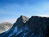
For those looking for a remote, obscure Sierra peak that few people outside of SPS list finishers have even heard of, let alone laid eyes upon, look no further. Tunemah Peak is located on the southern end of the White Divide, shortly before the divide plunges down to the Middle Fork of the Kings River some 6,000' below, and is reportedly one of just three places in California located more than twelve air miles from the nearest road. (Coyote Peaks in the Golden Trout Wilderness and Stubblefield Canyon in Yosemite are probably the others). It is neither especially prominent, nor particularly distinguished from most perspectives, and the climbing consists of a scree-and-talus trudge from most directions. Most trip reports seem to be peppered with descriptive phrases like "slog" and "angle-of-repose crudheap."But on the plus side... dang, it's tough to reach! Solitude is about as certain here as it is anywhere in the Sierra. The most reasonable approach is out of Wishon Reservoir, and involves approximately fifty miles round trip, with considerable cross-country travel. In addition to offering quite a challenge to anyone looking for a tough day out, summit views are also worthwhile, with a rarely seen vantage of the equally rarely visited Enchanted Gorge and the Black Divide.
Besides the obvious and enticing draws of remoteness, solitude, and obscurity, the peak is also of historical interest. Both it and Tunemah Lake were named for the nearby Tunemah Trail, an old cross country route of some notoriety. The trail's unusual name derived from the imprecations of Chinese cooks who traveled the rugged trail with sheepherders in 1878: "Teu-na-mah-ne! muck-a-hai! Yeu-nicky-shee-fut! Teu-na-mah-ne! Teu-na-mah-ne!" The curse reportedly translates to either 'Fuck your mother!" or "You fuck your grandmother." No one seems to be quite sure which. Whatever the exact translation, Tunemah Peak will seem one of the more aptly named summits in the range while one slogs up the remains of the Blue Canyon trail or the endless scree on the mountain's southwest slopes.
The peak is class 2 via its west or southwest slopes (keep to the west ridge for better footing and some contrived third class near the bottom to keep things slightly interesting). The long north/northwest ridge from Tunemah Lake and south ridge from Tunemah Pass (Peak 10,987') are also class 2.
Tunemah Peak is typically climbed in conjunction with nearby Finger Peak, also on the SPS List.
 |  |  |
Getting There
Driving directions: Follow the detailed driving directions on climber.org to the Rancheria Trailhead. In short, take SR168 east to Shaver Lake, and turn right on Dinkey Creek Road. Shortly before reaching the Dinkey Creek ranger station, turn right on McKinley Grove Road, following the signs to Wishon Reservoir. The trailhead is located a few miles past the dam spillway; just before the end of the pavement, turn left along Forest Service road 11S31 and follow this dirt road for about half a mile to the trailhead.Approach hike: To quote Dale Van Dalsem's trip report, "Everyone who has done [Tunemah Peak] says, 'We went in on route A, but don't do it that way; route B or C must be better." The author is no exception. Keep that in mind when considering the following.
Blue Canyon: The most obvious approach to the peak proceeds through Crown Valley to the old Blue Canyon trail, a long, boring hike. This hasn't been maintained in many years, and the trail has been essentially obliterated by blowdowns after the Crown Creek crossing. (I found this impossible to follow by headlamp, and only regained the trail in the vicinity of Kettle Dome. A GPS receiver could be very useful here, although the area is heavily forested and reception may be questionable). The trail is reasonable again through the lower reaches of Blue Canyon, but eventually disappears somewhere around the 8,000' elevation in the canyon. Fortunately, the cross-country travel from this point is relatively straightforward, with traces of the trail occasionally visible in places.
Follow the drainage up past Lake 10,401' and over Dykeman Pass (Pass 11,040'+, 0.4mi east of Lake 10,401'). Take a look at the unimpressive pile of sand and rubble that sits in front of you, and ponder again why you consider this "fun." Descend about 600' over slabs and grass to Alpine Creek, and climb the peak's west ridge. Variations: The Blue Canyon trail can also be reached by crossing Coyote Pass, although this involves more elevation gain and is unlikely to be any faster. Tunemah Peak can be reached from Blue Canyon by crossing the saddle north of Burnt Mountain rather than following the drainage (i.e. following the old Tunemah Trail), although this is also unlikely to be any faster.
Crown Creek/Traverse from Finger Peak: Although longer, this is a far more enjoyable option than the Blue Canyon trail: It is more scenic, and although it involves more cross-country hiking, the route-finding is much easier than trying to follow the traces of the old Blue Canyon trail. This approach is most efficient when climbing Finger Peak in conjunction with Tunemah Peak, as most parties will do.
Follow the trail to Crown Valley, and then head north first on the Crown Pass trail and then on the Coyote Pass/Mountain Meadow trail. After crossing several streams, the Coyote Pass trail crosses Crown Creek in an open, sandy area. Leave the trail here, and follow the creek upstream. The first mile or so is the most tedious portion, with some blowdowns to negotiate; an intermittent use trail may be found through here to ease progress. After this, the going improves dramatically, with easy walking through open forest and several miles of slabs in a beautiful valley. Follow the stream up to Hummingbird Lake, hiking up some slabs reminiscent of Tenaya Canyon, and cross over Mantle Pass (Pass 11,040'+, 0.6mi east of Hummingbird Lake). Tunemah Peak is reached from this point by traversing past Finger Peak's south ridge (or by climbing that peak and descending its sandy southeast slopes), and crossing Pass 11,720'+, 0.3mi NW of Tunemah Lake (class 3-4 if taken directly, or probably class 2 if crossed further north). It is straightforward to follow the White Divide south to Tunemah Peak from here.
Other approaches: An even longer, more difficult, but admittedly more scenic approach is possible out of Cedar Grove. Follow the Copper Creek Trail over Granite Pass to Simpson Meadow, and ford the Middle Fork Kings River (feasible only in late season). Bushwhack up Goddard Creek (hot and difficult), and follow the old Tunemah route to Tunemah Pass, from where the peak is an easy scramble. It would take a very sick person to want to climb the peak using this approach.
 |  |
Red Tape
The peak lies in the Kings Canyon National Park backcountry, and the usual wilderness red tape applies. Campfires are prohibited above 10,000', and backcountry camping requires a wilderness permit, obtainable from Sierra National Forest if entering the wilderness from Wishon Reservoir. This can be picked up from the ranger station in Prather, located along SR168 just east of town, or Dinkey Creek (summer only), located along Dinkey Creek Road just past the turnoff for Wishon Reservoir. Contact information is found on the Sierra NF High Sierra Ranger District recreation page.When To Climb
Remarkably, the peak has been skied in the spring as part of a trans-Sierra traverse. Nonetheless, most sane people head out here in the summer months (June through October).In the past, the crossing of Crown Creek has been troublesome during the spring runoff (RJ Secor nearly drowned here some years ago). As of October 2005, there's a good log crossing that avoids this problem if taking the Blue Canyon trail. The cross-country approach via Crown Creek and Mantle Pass involves a couple of stream crossings to keep to the easiest passage, and this may still be difficult in early season.
Camping
Comfortable bivy spots, with established fire rings and bear boxes, are found at the Rancheria trailhead. Abundant options for backcountry camping are found amongst the lakes and streams throughout the upper reaches of Blue Canyon and the Alpine Creek drainage.Last minute groceries and supplies can be purchased at the Wishon store, shortly before reaching the reservoir.
 |
Mountain Conditions
Sierra National Forest conditions report.NWS Forecast.
Etymology
"The sheepherders frequenting that part of the country employed Chinese cooks. Owing to the roughness of the path they gave vent to their disgust by numerous Chinese imprecations. Gradually the most prominent settled itself on to the trail and it became known as 'Tunemah!' The other features were named when the Tehipite and Mount Goddard quadrangles were surveyed in the 1900s. Chinese linguist colleagues in Hong Kong have identified 'Tunemah' as probably reflecting Cantonese diu2 nei5 aa3 maa1 (the numbers indicate tones), meaning 'Fuck your mother!'"- Erwin Gudde, California Place Names
"There was once a 'Tunemah Pass' (on the Tehipite 30' maps, 1905-47), and a 'Tunemah Trail' -- long abandoned. It was the latter that gave birth to the dreadful name, as a herd of sheep belonging to Frank Dusy and Bill Coolidge was forced down a precipitous trail into Simpson Meadow, in 1878.
'Two Chinese herders -- appalled by the awful chasm confronting them -- worked to a point of exhaustion by their desperate efforts to force the massed and balking sheep onward -- cursed the sheep, the dogs, the trail and all other related factors, in the most forcible epithets known to the celestial vocabulary. Above the bleating of the sheep and the barking of the frantic dogs, from the enveloping clouds of dust, there repeatedly and wrathfully resounded, "Teu-na-mah-ne! muck-a-hai! Yeu-nicky-shee-fut! Teu-na-mah-ne! Teu-na-mah-ne!" -- a thousand times. ... Peck and Nye (Dusy's head packers) agreed to call the sheep plunge "Teu-na-mah-ne."' (Winchell, 159.)
And what does it mean? It means something as horrible as 'You sleep with your grandmother.' It might even mean something worse than that. Consult your local authority."
- Peter Browning, Place Names of the Sierra Nevada
External Links
- CHAOS trip to Tunemah Peak and the Middle Fork Kings River
- climber.org trip reports
- SPS trip reports
Bob Burd - Jul 27, 2009 10:55 pm - Voted 10/10
Burnt MtnI think the route over the pass north of Burnt Mtn is better than Dykeman Pass. I went over Dykeman, but came back the other way. It was easy going on the east side of the pass, a bit wet and meadowy on the west side, but took only two hour to go from the summit back to the trail in Blue Canyon. It would be a bigger pain going uphill on the west side, but I think it'd be faster than that circuitous route over Dykeman. And not so much elevation gain, either.
guydahms123 - Aug 18, 2012 2:25 pm - Hasn't voted
Crown Creek approach.I would not recommend the approach up crown Creek, using the "Mountain Meadow/Coyote Pass" trail from Crown Valley any more. As of 8/2012, a forest fire sometime in the recent past has negatively affected the trail, obliterating the trail tread in sections. At the crossing of Crown Creek, the fire incinerated everything (burnt sticks for trees and much new brush growth since the fire), but the entire length of the trail (from the signboard at the west-end junction with the trail to Crown Lake all the way to the Crown Creek crossing) has been affected. There are patches of fire evidence wiping out the trail interspersed with unaffected sections of trail. The fire damage extends a mile or two up the Crown Creek drainage from the trail crossing, before one enters the enjoyable forest-and-slab walking that Mathew mentions.