
|
|
Mountain/Rock |
|---|---|
|
|
35.69700°N / 115.452°W |
|
|
5881 ft / 1793 m |
|
|
Overview
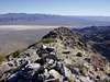
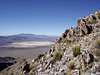
Lying some 60 miles south of Mount Stirling, the northernmost named peak in the Spring Mountains of southern Nevada, home of such well-known and eclectic peaks as Mt. Charleston, Mummy Mountain, Bridge Mountain and Black Velvet Peak, is Devil Peak, the southernmost named peak in the range.Steep on all sides, this obscure little peak, with a striking pyramidal shape, lies only two miles from the California/Nevada border outside of Jean, Nevada. Devil Peak is clearly visible as the most prominent peak resting on the western outskirts of this small and uncharming gambling town.
Though the going is steep, hiking to Devil’s summit is an easy endeavor. The most common route, detailed in Andy Zdon’s classic desert hiking guidebook ‘Desert Summits’, climbs the peak via its south ridge, gaining about 2300 feet over a mile and a half. The views from the summit, and along the sharp ridge leading to the highpoint, are stellar.
And speaking of Zdon’s fabulous book, he comments that the rarely visited peak’s register had not been signed in 6 years when he stopped by. Being the lover of obscure peaks that I am, that’s what motivated me to check it out. Sadly, obscure peaks don’t always remain obscure…especially when there’s a guidebook mention. On my visit, 15 years after Zdon’s, I observed a couple dozen entries…still not bad, though.
 |  |
Getting There
Devil Peak is about a 30-minute drive from Las Vegas.From Las Vegas, take highway 15 south toward California. About 24 miles or so outside of the city, get off at the Jean exit. It’ll be recognizable by the casinos and the generally distasteful neon flavor.
At the bottom of the exit, go east under the interstate and then turn south onto a frontage road that runs behind the casinos, etc.
Follow the frontage road for almost 6 miles until the pavement turns to dirt. A hundred yards after turning to dirt, the road bends sharply to the right and goes under the interstate. Follow it.
Once through the tunnel, you’ll immediate encounter a fork, though the right-bearing road is fainter. Stick to the main dirt road. This road heads directly toward Devil Peak, which is very obvious.
Continuing on the main dirt road, ignore the occasional side road that branches off. Although the main road bends a little as get closer to Devil Peak, rest assured that it’s the correct one.
Rough in places, requiring a high clearance vehicle in the best of conditions and a 4x4 in the worst, about 5 miles after leaving the highway tunnel the road will enter the mouth of a canyon below the base of Devil Peak. You might as well park here because the road gets a bit washed out beyond this point.
Red Tape
None that I know of.Not so much an issue of red tape as an issue of safety, there are many open mines in the area of Devil Peak. I recommend that you do not explore them.
When To Climb
Year-round, though the summers are brutally and unreasonably hot. There’s no water in the area, so bring lots of your own – particularly if you’re idiotic, I mean, courageous enough to do the peak in the summer.Camping
Devil Peak is on BLM land. Primitive camping is allowed.Those requiring creature comforts can stay in one of the casinos/hotels in Jean, if they want. Not sure why you’d want to.
Mountain Conditions
Granted Devil Peak is a bit south of Las Vegas, but the weather should be comparable.The peak could be done in a blizzard, which of course would never occur there anyway.
MissRealtorWood - May 6, 2014 8:22 pm - Hasn't voted
approach to trailhead updateSince this post was written some time ago, a few changes have taken place that should be mentioned. All is as usual and, if you set the odometer exactly as you enter the tunnel passing back under the highway after you've exited at Jean, you'll be traveling another *4.1 miles to the end of the drivable road. *you will be confronted by a fork immediately after the tunnel. The left fork becomes a sort of frontage road to the highway. Ignore it and drive TOWARD the mountains. *you will take a left fork further up. There were several other little offshoot roads but we aimed straight for the mountain and that stood us in good stead. The road becomes Monster-Truck worthy after 4.1 miles and so we pulled over. The wind was blowing up a storm and nearly knocked me over more than once. We aborted the hike because we had a plane to catch. In retrospect, the wind was a lifesaver because we had a flat tire on the way back and were able to take care of that without stressing over time because we ended the hike so early. *there